Introduction
The National Airspace System (NAS) is the network of all components regarding airspace in the United States. This comprehensive label includes air navigation facilities, equipment, services, airports or landing areas, aeronautical charts, information/services, rules, regulations, procedures, technical information, manpower, and material. Many of these system components are shared jointly with the military. To conform to international aviation standards, the United States adopted the primary elements of the classification system developed by the International Civil Aviation Organization (ICAO). This chapter provides a general discussion of airspace classification. Detailed information on the classification of airspace, operating procedures, and restrictions is found in the Aeronautical Information Manual (AIM).
This handbook departs from the conventional norm, in that the airspace discussions are presented in reverse order, in the belief that it is much easier to learn the airspace from least complicated to most complicated; also, the information presented for basic visual flight rules (VFR) weather minimums is only that necessary for balloon operations. [Figure 5-1] Other information, specifically for instrument flight rules (IFR) flying or night flight, has been omitted, as it has little or no value to the balloon pilot. For a complete discussion of these issues, the balloon pilot should refer to the AIM, or FAA-H- 8083-25, Pilot’s Handbook of Aeronautical Knowledge.
Airspace Classification
The two categories of airspace are regulatory and non- regulatory. Within these two categories, there are four types: uncontrolled, controlled, special use, and other airspace. Figure 5-2 presents a profile view of the dimensions of various classes of airspace. It will be helpful to refer to this figure as this chapter is studied, as well as remembering that almost all sport balloon operations are conducted in Class E or G airspace.

Figure 5-1. Basic weather minimums for balloon operations in the different classes of airspace.
Uncontrolled Airspace
Class G Airspace
Class G or uncontrolled airspace is the portion of the airspace that has not been designated as Class A, B, C, D, or E. Class G airspace extends from the surface to the base of the overlying Class E airspace. Although air traffic control (ATC) has no authority or responsibility to control air traffic within Class G airspace, pilots should remember there are VFR minimums which apply while operating in it. Class G airspace is essentially uncontrolled by ATC except when associated with a temporary control tower. [Figures 5-2 and 5-3]
In the eastern half of the United States, most Class G airspace is overlaid with Class E airspace, beginning at either 700 or 1,200 feet above ground level (AGL). In the western half of the United States, much of the Class G airspace goes up to 14,500 feet before the Class E airspace begins. The pilot is advised to consult the appropriate sectional chart to ensure that he or she is aware of the airspace limits prior to flight in an unfamiliar area.
Most balloon operations are conducted in Class G airspace. There are no communications requirements to operate in Class G airspace. If operations are conducted at an altitude of 1,200

Figure 5-2. Dimensions of various classes of airspace.

Figure 5-3. Class G airspace.
feet or less AGL, the pilot must remain clear of clouds, and there must be one statute mile of visibility. If the operations are conducted more than 1,200 feet AGL, but less than 10,000 feet mean sea level (MSL), visibility requirements remain at one statute mile, but cloud clearances are 1,000 feet above, 500 feet below, and 2,000 feet horizontally from any cloud(s). A popular mnemonic tool used to remember basic cloud clearances is “C152,” a popular fixed-wing training aircraft. In this case, the mnemonic recalls, “Clouds 1,000, 500, and 2,000.”
Controlled Airspace
Controlled airspace is a generic term that covers the different classifications of airspace and defined dimensions within which ATC service is provided in accordance with the airspace classification. Controlled airspace consists of:
- Class A
- Class E
- Class D
- Class C
- Class B
Class E Airspace
Generally, if the airspace is not Class A, B, C, or D, and is controlled airspace, then it is Class E airspace. Class E airspace extends upward from either the surface or a designated altitude to the overlying or adjacent controlled airspace. [Figures 5-2 and 5-4] Also in this class are federal airways and airspace beginning at either 700 or 1,200 feet AGL used to transition to and from the terminal or en route environment. Unless designated at a lower altitude, Class E airspace begins at 14,500 MSL over the United States, including that airspace overlying the waters within 12 nautical miles (NM) of the coast of the 48 contiguous states and Alaska, up to but not including 18,000 feet MSL, and the airspace above FL 600.
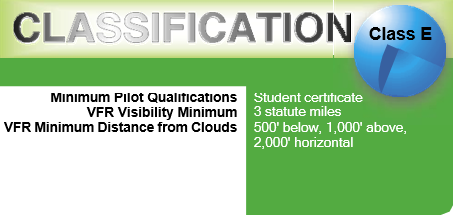
Figure 5-4. Class E airspace.
There are no specific communications requirements associated with Class E airspace; however, some Class E airspace locations are designed to provide approaches for instrument approaches, and a pilot would be prudent to ensure that appropriate communications are established when operating near those areas.
Visibility and cloud clearances for operations conducted in Class E airspace are similar to those of the Class G airspace. If balloon operations are being conducted below 10,000 feet MSL, visibility is three statute miles and the basic VFR cloud clearance requirements of 1,000 feet above, 500 feet below, and 2,000 feet horizontal (remember the C152 mnemonic). Operations above 10,000 feet MSL require visibility of five statute miles and cloud clearance of 1,000 feet above, 1,000 feet below, and one statute mile horizontally.
Class D Airspace
Class D is that airspace from the surface to 2,500 feet AGL (but charted in MSL) surrounding those airports that have an operational control tower. [Figures 5-2 and 5-5] The configuration of each Class D airspace area is individually tailored. When instrument procedures are published, the airspace is normally designed to contain the procedures.
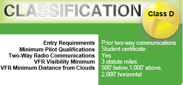
Figure 5-5. Class D airspace.
Unless otherwise authorized, each aircraft must establish two-way radio communications with the ATC facility providing air traffic services prior to entering the airspace and thereafter maintain those communications while in the airspace. Balloon pilots approaching Class D airspace should call the ATC facility at a point where, if entry is denied, a safe landing can still be executed. It is important to understand that if the controller responds to the initial radio call without using the balloon’s call sign, radio communications have not been established, and the balloon may not enter the Class D airspace. Many airports associated with Class D airspace do not operate on a 24-hour-a-day basis. When not in operation, the airspace will normally revert to Class E or G airspace, with no communications requirements. In either case, balloon pilots are reminded that, in the absence of an emergency situation, there is no absolute requirement to land at the airport associated with the Class D airspace. In most cases, the first radio call will be made at a distance of five statute miles from the airport.
Balloon pilots operating in the vicinity of an airport should exercise discretion. While balloons indeed have the right of way over all powered aircraft as stated in Title 14 of the Code of Federal Regulations (14 CFR) part 91, section 91.113, a pilot would cause less disruption by landing well short of the airport. This is nothing more than common courtesy and common sense. The visibility requirement for Class D airspace is three statute miles; cloud clearances are the standard VFR 1,000/500/2,000.
Class C Airspace
Class C airspace normally extends from the surface to 4,000 feet above the airport elevation surrounding those airports having an operational control tower, that are serviced by a radar approach control, and with a certain number of IFR or passenger operations. [Figures 5-2 and 5-6] This airspace is charted in feet MSL, and is generally of a five NM radius surface area that extends from the surface to 4,000 feet above the airport elevation, and a 10 NM radius area that extends from 1,200 feet to 4,000 feet above the airport elevation. There is also a noncharted outer area with a 20 NM radius, which extends from the surface to 4,000 feet above the primary airport, and this area may include one or more satellite airports. [Figure 5-7]
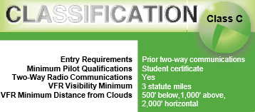
Figure 5-6. Class C airspace.

Figure 5-7. Example of Class C airspace on a sectional.
Balloon operations in Class C airspace, while technically feasible, are usually not advisable. To fly an aircraft in Class C airspace requires not only a two-way radio to establish and maintain contact with ATC, but also an encoding transponder. Very few balloons carry a transponder in normal operations. As a practical matter, under certain circumstances and with prior coordination, it is possible to enter or depart Class C airspace without an operational transponder, but the practice is generally discouraged. It is possible to fly in the vicinity of a Class C airport; for example, under the lower lateral limits of the outer layer, without needing to penetrate the inner circle. Again, a balloon pilot is well advised to remain clear of the controlled airspace, as a matter of common courtesy and good public relations.
Cloud clearances in Class C airspace are the same as Class D airspace: visibility of three statute miles and a distance from clouds of 1,000/500/2,000.
Class B Airspace
Class B airspace is generally airspace from the surface to 10,000 feet MSL surrounding the nation’s busiest airports in terms of airport operations. [Figures 5-2 and 5-8] The configuration of each Class B airspace area is individually tailored, consists of a surface area and two or more layers (some Class B airspace areas resemble upside-down wedding cakes). An ATC clearance is required for all aircraft to operate in the area, and all aircraft that are so cleared receive separation services within the airspace.
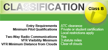
Figure 5-8. Class B airspace.
As a general rule, balloons do not freely operate within Class B airspace. Equipment requirements are the same as for Class C airspace; however, due to air traffic congestion, the balloon pilot requesting entry to Class B airspace will likely be denied entry, as ballooning operations inside the Class B airspace constitute a potential traffic conflict. Most traffic transiting the Class B airspace is being flown under an IFR flight plan, or, in the very least, provide a radar signature which allows ATC to provide traffic separation. Due to their construction, balloons do not provide a radar return much larger than a small flock of birds (and are frequently mistaken as such).
Should it become necessary for operational reasons to fly through Class B airspace, that flight should be coordinated at least one hour prior, as provided for by 14 CFR section
91.215. It is permissible, and perfectly legal, to operate a balloon under the lateral limits of the Class B airspace. Balloon pilots operating in the vicinity of Class B airspace are encouraged to be familiar with the airspace, including visual ground reference points when conducting flight under the lateral limits to avoid inadvertently encroaching on Class B airspace. Since aircraft operating in Class B airspace are under radar control, there is a slight difference in the cloud clearance requirements. Visibility remains three statute miles, but the only cloud clearance requirement is that the pilot remain clear of clouds.
Class A Airspace
Class A airspace is generally the airspace from 18,000 feet MSL up to and including FL 600, including the airspace overlying the waters within 12 NM of the coast of the 48 contiguous states and Alaska. Unless otherwise authorized, all operations in Class A airspace are conducted under IFR. For that reason, balloons do not utilize the Class A airspace, unless operated on a waiver or are conducting some special operation, such as a record attempt.
Special Use Airspace
Special Use Airspace (or Special Area of Operation) is the designation for airspace in which certain activities must be confined, or where limitations may be imposed on aircraft operations that are not part of those activities. Certain special use airspace areas can create limitations on the mixed use of airspace. The special use airspace depicted on sectional charts includes the area name or number, effective altitude, time and weather conditions of operation, the controlling agency, and the chart panel location. On National Aeronautical Charting Group (NACG) sectional charts, this information is available on one of the end panels.
Special use airspace usually consists of:
- Prohibited areas
- Restricted areas
- Warning areas
- Military operation areas (MOAs)
- Alert areas
- Controlled firing areas
Prohibited Areas
Prohibited areas contain airspace of defined dimensions within which the flight of aircraft is prohibited. Such areas are established for security or other reasons associated with the national welfare. These areas are published in the Federal Register and are depicted on aeronautical charts. The area is charted as a “P” followed by a number (e.g., “P-49”). [Figure 5-9] Examples of prohibited areas include Camp David and the National Mall in Washington, D.C., where the White House and Congressional buildings are located.
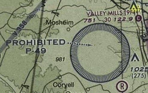
Figure 5-9. An example of a prohibited area is Crawford, Texas.
Restricted Areas
Restricted areas are areas where operations are hazardous to nonparticipating aircraft and contain airspace within which the flight of aircraft, while not wholly prohibited, is subject to restrictions. Activities within these areas must be confined because of their nature, or limitations may be imposed upon aircraft operations that are not a part of those activities, or both. Restricted areas denote the existence of unusual, often invisible, hazards to aircraft (e.g., artillery firing, aerial gunnery, or guided missiles). Penetration of restricted areas without authorization from the using or controlling agency may be extremely hazardous to the aircraft and its occupants. ATC facilities apply the following procedures:
- If the restricted area is not active and has been released to the Federal Aviation Administration (FAA), the ATC facility will allow the aircraft to operate in the restricted airspace without issuing specific clearance for it to do so.
- If the restricted area is active and has not been released to the FAA, the ATC facility will issue a clearance which will ensure the aircraft avoids the restricted airspace.
Restricted areas are charted with an “R” followed by a number (e.g., “R-4401”) and are depicted on the sectional charts. [Figure 5-10] Restricted area information can be obtained on the back of the chart. [Figure 5-11]

Figure 5-10. Restricted areas on a sectional chart.

Figure 5-11. Specific information about a restricted area can be found on the back of the sectional chart.
Warning Areas
Warning areas consist of airspace which may contain hazards to nonparticipating aircraft in international airspace. The activities may be much the same as those for a restricted area. Warning areas are established beyond the three mile limit and are depicted on aeronautical charts. Warning Areas are also defined on the backside of the appropriate sectional chart. [Figure 5-11]
Military Operation Areas
Military operation areas (MOA) consist of airspace of defined vertical and lateral limits established for the purpose of separating certain military training activity from IFR traffic. There is no restriction against a pilot operating VFR in these areas; however, a pilot should be alert since training activities may include acrobatic and abrupt maneuvers. MOAs are depicted by name and with defined boundaries on sectional, VFR terminal area, and en route low altitude charts and are not numbered (e.g., “Camden Ridge MOA”). [Figure 5-12] However, the MOA is also further defined on the back of the sectional chart with times of operation, altitudes affected, and the controlling agency. [Figure 5-13]

Figure 5-12. Camden Ridge MOA is an example of a military operations area.
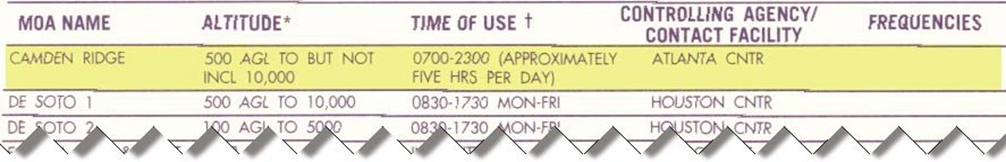
Figure 5-13. Additional information found on the sectional chart for Camden Ridge MOA.
Alert Areas
Alert areas are depicted on aeronautical charts with an “A” followed by a number (e.g., “A-211”) to inform nonparticipating pilots of areas that may contain a high volume of pilot training or an unusual type of aerial activity. Pilots should exercise caution in alert areas. All activity within an alert area shall be conducted in accordance with regulations, without waiver, and pilots of participating aircraft, as well as pilots transiting the area, shall be equally responsible for collision avoidance. [Figure 5-14]

Figure 5-14. Alert area (A-211).
Controlled Firing Areas
Controlled firing areas contain military activities, which, if not conducted in a controlled environment, could be hazardous to nonparticipating aircraft. The difference between controlled firing areas and other special use airspace is that activities must be suspended when a spotter aircraft, radar, or ground lookout position indicates an aircraft might be approaching the area.
Other Airspace Areas
“Other airspace areas” is a general term referring to the majority of the remaining airspace. It includes:
- Airport advisory areas
- Military training routes (MTR)
- Temporary flight restrictions (TFR)
- National security areas
Airport Advisory Areas
An airport advisory area is an area within 10 statute miles (SM) of an airport where a control tower is not operating, but where a flight service station (FSS) is located. At these locations, the FSS provides advisory service to arriving and departing aircraft.
Military Training Routes (MTRs)
Military Training Routes (MTRs) are routes used by military aircraft to maintain proficiency in tactical flying. These routes are usually established below 10,000 feet MSL for operations at speeds in excess of 250 knots. Some route segments may be defined at higher altitudes for purposes of route continuity. Routes are identified as IFR (IR), and VFR (VR), followed by a number. MTRs with no segment above 1,500 feet AGL are identified by four number characters (e.g., IR1206, VR1207). MTRs that include one or more segments above 1,500 feet AGL are identified by three number characters (e.g., IR206, VR207). IFR Low Altitude En Route Charts depict all IR routes and all VR routes that accommodate operations above 1,500 feet AGL. IR routes are conducted in accordance with IFR regardless of weather conditions.
MTR are usually indicated with a blue line on the sectional chart. A balloon pilot flying in the area of numerous VRs or IRs should question the briefer during the weather brief to find out if any of the routes are in use, and a possible time frame for opening and closing. While it is true that the balloon pilot has the right of way, the balloon will generally come out worse in a midair conflict with a fast-moving military aircraft. MTRs, such as the example depicted in Figure 5-15, are also further defined on the back of the sectional charts.

Figure 5-15. Military training routes (MTR) chart symbols.
Temporary Flight Restrictions (TFRs)
Temporary flight restrictions (TFRs) are put into effect when traffic in the airspace would endanger or hamper air or ground activities in the designated area. For example, a forest fire, chemical accident, flood, or disaster-relief effort could warrant a TFR, which would be issued as a Notice to Airmen (NOTAM). The NOTAM begins with the phrase “FLIGHT RESTRICTIONS” followed by the location of the temporary restriction, effective time period, area defined in statute miles, and altitudes affected. The NOTAM also contains the FAA coordination facility and telephone number, the reason for the restriction, and any other information deemed appropriate. The pilot should check the NOTAMs as part of flight planning.
The reasons for establishing a temporary restriction are:
- Protect persons and property in the air or on the surface from an existing or imminent hazard;
- Provide a safe environment for the operation of disaster relief aircraft;
- Prevent an unsafe congestion of sightseeing aircraft above an incident or event, which may generate a high degree of public interest;
- Protect declared national disasters for humanitarian reasons;
- Protect the President, Vice President, or other public figures; and
Since the events of September 11, the use of TFRs has become much more common. There have been a number of incidents of aircraft incursions into TFRs, which have resulted in pilots undergoing security investigations, and certificate suspensions. It is a pilot’s responsibility to be aware of TFRs in their proposed area of flight. One way to check is to visit the FAA’s web site, at www.tfr.faa.gov, and verify that there is not a TFR in the area. [Figure 5-16]

Figure 5-16. A temporary flight restriction (TFR) imposed at Boston’s Logan Airport to general aviation and restricting operations at surrounding airports
Another TFR issue that the balloon pilot needs to be aware of are the restrictions imposed under 14 CFR part 91, section
91.145. In this regulation, the FAA has codified restrictions against the overflight of major outdoor events, such as the World Series, the Rose Bowl, and NASCAR events. Several years ago, it was relatively common to see hot air balloons promoting products or services being flown over these events, providing exposure for the commercial sponsor. Now, there are significant distance and altitude restrictions for such events, and any operations inside the TFR area must be conducted under the provisions of a waiver. Should such an operation be contemplated, the balloon pilot should consult with the local Flight Service District Office (FSDO) well in advance of the event.
National Security Areas
National security areas (NSAs) consist of airspace with defined vertical and lateral dimensions established at locations where there is a requirement for increased security and safety of ground facilities. Flight in NSAs may be temporarily prohibited by regulation under the provisions of 14 CFR part 99, and prohibitions will be disseminated via NOTAM.
Radio Communications
When utilizing the NAS, there are many occasions when it is necessary to communicate with a control tower, a controlling agency, or another aircraft. Balloon pilots should have a working knowledge of correct radio procedures in order to properly exercise their privileges, and not interfere with other aviation traffic.
Aviation very-high-frequency (VHF) radios may be used for communications between the balloon pilot and towers, pilot to FSS, air to air (pilot to pilot), air to ground in some circumstances, and to get information from weather facilities and automated stations. VHF radios are not to be used as a “telephone service” or in a Citizen’s Band-type of operation; this use is specifically prohibited by the Federal Communications Commission (FCC), and may result in monetary fines.
There is no license requirement for a pilot operating in the United States; however, a pilot who may be operating outside the country is required to hold a restricted radiotelephone permit issued by the FCC. There is also no station license requirement for a handheld radio used in a balloon, as it is not permanently mounted. A station license may be required when a balloon is operated outside the country; it is best to check with the appropriate local authorities before contemplating such an operation.
The single most important aspect of radio communication is clarity. Keeping one’s transmissions brief, and using correct terminology and phraseology when operating an aircraft radio is imperative. All frequencies are shared with others; a pilot’s idle chatter to a chase crew could inadvertently block another pilot’s emergency transmission at an airfield many miles away. A good pilot will minimize radio requirements, and think before speaking.
Phonetic Alphabet
The ICAO, of which the United States is a member, has adopted a phonetic alphabet, which should be used in radio communications as necessary. When communicating with air traffic control facilities, pilots should use this alphabet to identify their aircraft. [Figure 5-15]
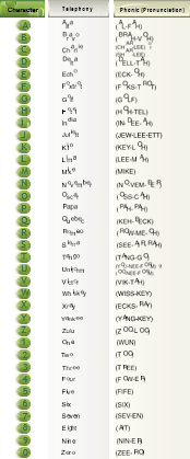
Figure 5-17. Phonetic alphabet.
Radio Procedures
The Pilot/Controller Glossary (found in the AIM) contains correct language for communications between a pilot at ATC facilities. Good phraseology enhances safety and is the mark of a conscientious pilot. Jargon, slang, and “CB” codes should not be used in radio communications.
A pilot should listen to the radio before transmitting. Do not clutter the frequency with inappropriate requests or irrelevant information. Most pilots will think before keying their radio, and keep the transmission as brief as possible. The pilot should be occupied with control of the balloon and should not be spending time on the radio.
When Departing a Nontowered Airport
A balloon pilot departing a nontowered airport should make a call on the field’s UNICOM or CTAF (Common Traffic Advisory Frequency), both of which are generally shown on the appropriate sectional chart. The pilot should state his or her location and intentions, as a “self-announce” advisory, so that other air traffic in the area is aware of the operation.
Example: “Williamson traffic, balloon 3584 Golf departing the grass near hanger 12 to the east.”
When Approaching a Nontowered Airport
If an approach to a nontowered airport is conducted, with the intent to land, the pilot should again “self-announce” on the appropriate UNICOM frequency or CTAF. The current location should be stated, as well as the pilot’s intentions.
Example: “Air Acres traffic, balloon 3584 Golf approaching from the west for landing at the departure end of the runway.”
When Transiting a Nontowered Facility
If flight in the vicinity of a nontowered airport is likely, with no intent to land at the airfield, it is appropriate to let other aircraft in the area know the intentions, particularly if there is the possibility of interfering with the traffic pattern.
Example: “Enterprise traffic, balloon 7510 Delta at 700 feet, transiting from east to west along the north boundary of the field, no landing.”
When Approaching Controlled Airspace
When approaching controlled airspace, and it appears that entry into the airspace is likely (or desired), the balloon pilot should contact the appropriate approach control with enough time to execute a landing, should entry be denied. Remember that a balloon usually does not have the option of turning around.
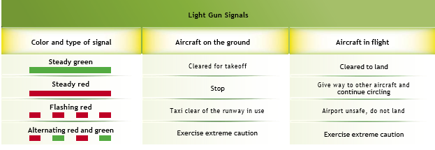
Figure 5-18. Light gun signals.
Example: “Huntsville Approach, balloon 903 Hotel Delta, at 3,000.”
The approach control facility (in this example, Huntsville Approach) will either reply by saying, “Aircraft calling Huntsville Approach, standby”, in which case the balloon pilot does not have a clearance to enter the airspace; or, approach will reply, saying “Balloon 903 Hotel Delta, Huntsville, standby.” In this case, the aircraft call sign was used, and the pilot may enter the airspace. Further communication may continue until the balloon has either landed or cleared the airspace.
In the event that radio communication has failed, or that no radio is available in the balloon, and continued flight into the immediate vicinity of an towered airport facility cannot be avoided, control towers have a “light gun” available. This device, which looks like an oversized flare gun, allows tower personnel to “shoot” a directed beam of light at an approaching aircraft, and may signal field availability options to the approaching balloon. [Figure 5-16]
Many balloon pilots fly for years without using a radio of any kind. Using an aircraft radio is not a difficult task, and, with practice, can provide a more enjoyable flight. Most ATCs express an interest in balloons, and go out of their way to assist balloon pilots in accomplishing their flight safely.
Chapter Summary
At first glance, the NAS appears to be a complex arena in which to operate such a simple aircraft. This chapter simplifies the airspace to the reader, and makes it readily apparent that it is possible to operate a hot air balloon safely, without causing conflict.
Simple courtesy and common sense goes a long way in airspace operations. A complete and thorough understanding of the airspace, combined with good decision-making, will allow the pilot to do what he or she wishes, with recognition of the needs of other users of the sky.


