Introduction
The two categories of airspace are: regulatory and nonregulatory. Within these two categories, there are four types: controlled, uncontrolled, special use, and other airspace. The categories and types of airspace are dictated by the complexity or density of aircraft movements, nature of the operations conducted within the airspace, the level of safety required, and national and public interest. Figure 2-1 presents a profile view of the dimensions of various classes of airspace.

Figure 2-1. Airspace profile.
Controlled Airspace
Controlled airspace is a generic term that covers the different classifications of airspace and defined dimensions within which air traffic control (ATC) service is provided in accordance with the airspace classification. Controlled airspace that is of concern to the remote pilot is:
• Class B
• Class C
• Class D
• Class E
Class B Airspace
Class B airspace is generally airspace from the surface to 10,000 feet mean sea level (MSL) surrounding the nation’s busiest airports in terms of airport operations or passenger enplanements. The configuration of each Class B airspace area is individually tailored, consists of a surface area and two or more layers (some Class B airspace areas resemble upside-down wedding cakes), and is designed to contain all published instrument procedures once an aircraft enters the airspace. A remote pilot must receive authorization from ATC before operating in the Class B airspace.
Class C Airspace
Class C airspace is generally airspace from the surface to 4,000 feet above the airport elevation (charted in MSL) surrounding those airports that have an operational control tower, are serviced by a radar approach control, and have a certain number of instrument flight rules (IFR) operations or passenger enplanements. Although the configuration of each Class C area is individually tailored, the airspace usually consists of a surface area with a five nautical mile (NM) radius, an outer circle with a ten NM radius that extends from 1,200 feet to 4,000 feet above the airport elevation. A remote pilot must receive authorization before operating in Class C airspace.
Class D Airspace
Class D airspace is generally airspace from the surface to 2,500 feet above the airport elevation (charted in MSL) surrounding those airports that have an operational control tower. The configuration of each Class D airspace area is individually tailored and, when instrument procedures are published, the airspace is normally designed to contain the procedures. Arrival extensions for instrument approach procedures (IAPs) may be Class D or Class E airspace. A remote pilot must receive ATC authorization before operating in Class D airspace.
Class E Airspace
Class E airspace is the controlled airspace not classified as Class A, B, C, or D airspace. A large amount of the airspace over the United States is designated as Class E airspace. This provides sufficient airspace for the safe control and separation of aircraft during IFR operations. Chapter 3 of the Aeronautical Information Manual (AIM) explains the various types of Class E airspace.
Sectional and other charts depict all locations of Class E airspace with bases below 14,500 feet MSL. In areas where charts do not depict a class E base, class E begins at 14,500 feet MSL. In most areas, the Class E airspace base is 1,200 feet above ground level (AGL). In many other areas, the Class E airspace base is either the surface or 700 feet AGL. Some Class E airspace begins at an MSL altitude depicted on the charts, instead of an AGL altitude. Class E airspace typically extends up to, but not including, 18,000 feet MSL (the lower limit of Class A airspace). All airspace above FL 600 is Class E airspace.
Federal Airways, which are shown as blue lines on a sectional chart, are usually found within Class E airspace. Federal Airways start at 1,200’ AGL and go up to, but, not including 18,000’ MSL.
In most cases, a remote pilot will not need ATC authorization to operate in Class E airspace.
Uncontrolled Airspace
Class G Airspace
Uncontrolled airspace or Class G airspace is the portion of the airspace that has not been designated as Class A, B, C, D, or E. It is therefore designated uncontrolled airspace. Class G airspace extends from the surface to the base of the overlying Class E airspace. A remote pilot will not need ATC authorization to operate in Class G airspace.
Special Use Airspace
Special use airspace or special area of operation (SAO) is the designation for airspace in which certain activities must be confined, or where limitations may be imposed on aircraft operations that are not part of those activities. Certain special use airspace areas can create limitations on the mixed use of airspace. The special use airspace depicted on instrument charts includes the area name or number, effective altitude, time and weather conditions of operation, the controlling agency, and the chart panel location. On National Aeronautical Charting Group (NACG) en route charts, this information is available on one of the end panels. Special use airspace usually consists of: • Prohibited areas
• Restricted areas
• Warning areas
• Military operation areas (MOAs)
• Alert areas • Controlled firing areas (CFAs)
Prohibited Areas
Prohibited areas contain airspace of defined dimensions within which the flight of aircraft is prohibited. Such areas are established for security or other reasons associated with the national welfare. These areas are published in the Federal Register and are depicted on aeronautical charts. The area is charted as a “P” followed by a number (e.g., P-40). Examples of prohibited areas include Camp David and the National Mall in Washington, D.C., where the White House and the Congressional buildings are located. [Figure 2-2]
Restricted Areas
Restricted areas are areas where operations are hazardous to nonparticipating aircraft and contain airspace within which the flight of aircraft, while not wholly prohibited, is subject to restrictions. Activities within these areas must be confined because of their nature, or limitations may be imposed upon aircraft operations that are not a part of those activities, or both. Restricted areas denote the existence of unusual, often invisible, hazards to aircraft (e.g., artillery firing, aerial gunnery, or guided missiles). Penetration of restricted areas without authorization from the using or controlling agency may be extremely hazardous to the aircraft.
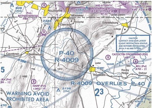
Figure 2-2. An example of a prohibited area, P-40 around Camp David.
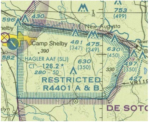
Figure 2-3. Restricted areas on a sectional chart.
- If the restricted area is not active and has been released to the FAA, the ATC facility allows the aircraft to operate in the restricted airspace without issuing specific clearance for it to do so.
- If the restricted area is active and has not been released to the FAA, the ATC facility issues a clearance that ensures the aircraft avoids the restricted airspace.
Restricted areas are charted with an “R” followed by a number (e.g., R-4401) and are depicted on the en route chart appropriate for use at the altitude or flight level (FL) being flown. [Figure 10-1] Restricted area information can be obtained on the back of the chart.
Warning Areas
Warning areas are similar in nature to restricted areas; however, the United States government does not have sole jurisdiction over the airspace. A warning area is airspace of defined dimensions, extending from 3 NM outward from the coast of the United States, containing activity that may be hazardous to nonparticipating aircraft. The purpose of such areas is to warn nonparticipating pilots of the potential danger. A warning area may be located over domestic or international waters or both. The airspace is designated with a “W” followed by a number (e.g., W-237). [Figure 2-4]
Military Operation Areas (MOAs)
MOAs consist of airspace with defined vertical and lateral limits established for the purpose of separating certain military training activities from IFR traffic. Whenever an MOA is being used, nonparticipating IFR traffic may be cleared through an MOA if IFR separation can be provided by ATC. Otherwise, ATC reroutes or restricts nonparticipating IFR traffic. MOAs are depicted on sectional, VFR terminal area, and en route low altitude charts and are not numbered (e.g., “Camden Ridge MOA”). [Figure 2-5] However, the MOA is also further defined on the back of the sectional charts with times of operation, altitudes affected, and the controlling agency.
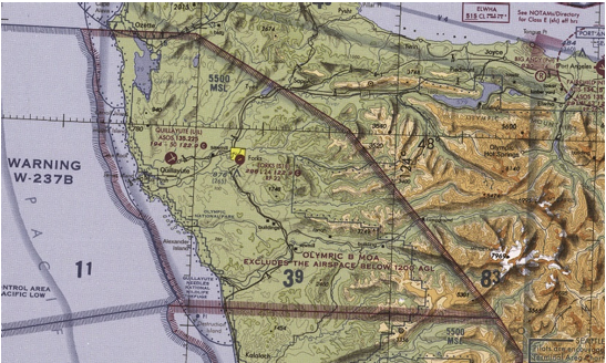
Figure 2-4. Requirements for airspace operations.
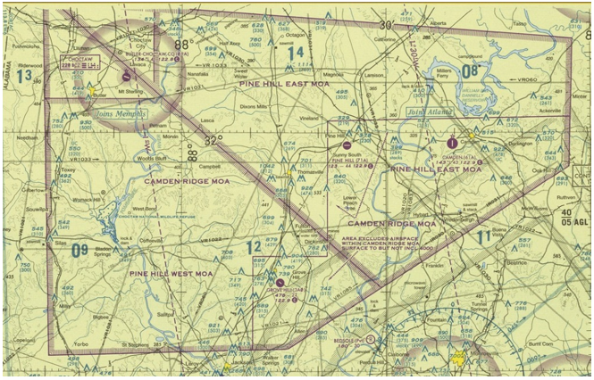
Figure 2-5. Camden Ridge MOA is an example of a military operations area.
Alert Areas
Alert areas are depicted on aeronautical charts with an “A” followed by a number (e.g., A-211) to inform nonparticipating pilots of areas that may contain a high volume of pilot training or an unusual type of aerial activity. Pilots should exercise caution in alert areas. All activity within an alert area shall be conducted in accordance with regulations, without waiver, and pilots of participating aircraft, as well as pilots transiting the area, shall be equally responsible for collision avoidance. [Figure 2-6]

Figure 2-6. Alert area (A-211).
Controlled Firing Areas (CFAs)
CFAs contain activities that, if not conducted in a controlled environment, could be hazardous to nonparticipating aircraft. The difference between CFAs and other special use airspace is that activities must be suspended when a spotter aircraft, radar, or ground lookout position indicates an aircraft might be approaching the area. There is no need to chart CFAs since they do not cause a nonparticipating aircraft to change its flight path.
Other Airspace Areas
“Other airspace areas” is a general term referring to the majority of the remaining airspace. It includes: • Local airport advisory (LAA)
• Military training route (MTR)
• Temporary flight restriction (TFR)
• Parachute jump aircraft operations
• Published VFR routes
• Terminal radar service area (TRSA)
• National security area (NSA)
• Air Defense Identification Zones (ADIZ) land and water based and need for Defense VFR (DVFR) flight plan to operate VFR in this airspace
• Flight Restricted Zones (FRZ) in vicinity of Capitol and White House
• Wildlife Areas/Wilderness Areas/National Parks and request to operate above 2,000 AGL • National Oceanic and Atmospheric Administration (NOAA) Marine Areas off the coast with requirement to operate above 2,000 AGL
• Tethered Balloons for observation and weather recordings that extend on cables up to 60,000
Local Airport Advisory (LAA)
An advisory service provided by Flight Service facilities, which are located on the landing airport, using a discrete ground-to-air frequency or the tower frequency when the tower is closed. LAA services include local airport advisories, automated weather reporting with voice broadcasting, and a continuous Automated Surface Observing System (ASOS)/Automated Weather Observing Station (AWOS) data display, other continuous direct reading instruments, or manual observations available to the specialist.
Military Training Routes (MTRs)
MTRs are routes used by military aircraft to maintain proficiency in tactical flying. These routes are usually established below 10,000 feet MSL for operations at speeds in excess of 250 knots. Some route segments may be defined at higher altitudes for purposes of route continuity. Routes are identified as IFR (IR), and VFR (VR), followed by a number. [Figure 2-7] MTRs with no segment above 1,500 feet AGL are identified by four number characters (e.g., IR1206, VR1207). MTRs that include one or more segments above 1,500 feet AGL are identified by three number characters (e.g., IR206, VR207). IFR low altitude en route charts depict all IR routes and all VR routes that accommodate operations above 1,500 feet AGL. IR routes are conducted in accordance with IFR regardless of weather conditions. VFR sectional charts depict military training activities, such as IR, VR, MOA, restricted area, warning area, and alert area information.

Figure 2-7. Military training route (MTR) chart symbols.
Temporary Flight Restrictions (TFR)
A flight data center (FDC) Notice to Airmen (NOTAM) is issued to designate a TFR. The NOTAM begins with the phrase “FLIGHT RESTRICTIONS” followed by the location of the temporary restriction, effective time period, area defined in statute miles, and altitudes affected. The NOTAM also contains the FAA coordination facility and telephone number, the reason for the restriction, and any other information deemed appropriate. The pilot should check the NOTAMs as part of flight planning.
Some of the purposes for establishing a TFR are:
• Protect persons and property in the air or on the surface from an existing or imminent hazard.
• Provide a safe environment for the operation of disaster relief aircraft.
• Prevent an unsafe congestion of sightseeing aircraft above an incident or event, that may generate a high degree of public interest.
• Protect declared national disasters for humanitarian reasons in the State of Hawaii. • Protect the President, Vice President, or other public figures.
• Provide a safe environment for space agency operations.
Since the events of September 11, 2001, the use of TFRs has become much more common. There have been a number of incidents of aircraft incursions into TFRs that have resulted in pilots undergoing security investigations and certificate suspensions. It is a pilot’s responsibility to be aware of TFRs in their proposed area of flight. One way to check is to visit the FAA website, www.tfr.faa.gov, and verify that there is not a TFR in the area.
Parachute Jump Aircraft Operations
Parachute jump aircraft operations are published in the Chart Supplement U.S. (formerly Airport/Facility Directory). Sites that are used frequently are depicted on sectional charts.
Published VFR Routes
Published VFR routes are for transitioning around, under, or through some complex airspace. Terms such as VFR flyway, VFR corridor, Class B airspace VFR transition route, and terminal area VFR route have been applied to such routes. These routes are generally found on VFR terminal area planning charts.
Terminal Radar Service Areas (TRSAs)
TRSAs are areas where participating pilots can receive additional radar services. The purpose of the service is to provide separation between all IFR operations and participating VFR aircraft.
The primary airport(s) within the TRSA become(s) Class D airspace. The remaining portion of the TRSA overlies other controlled airspace, which is normally Class E airspace beginning at 700 or 1,200 feet and established to transition to/ from the en route/terminal environment. TRSAs are depicted on VFR sectional charts and terminal area charts with a solid black line and altitudes for each segment. The Class D portion is charted with a blue segmented line. Participation in TRSA services is voluntary; however, pilots operating under VFR are encouraged to contact the radar approach control and take advantage of TRSA service.
National Security Areas (NSAs) NSAs consist of airspace of defined vertical and lateral dimensions established at locations where there is a requirement for increased security and safety of ground facilities. Flight in NSAs may be temporarily prohibited by regulation under the provisions of Title 14 of the Code of Federal Regulations (14 CFR) part 99 and prohibitions are disseminated via NOTAM. Pilots are requested to voluntarily avoid flying through these depicted areas.
Air Traffic Control and the National Airspace System
The primary purpose of the ATC system is to prevent a collision between aircraft operating in the system and to organize and expedite the flow of traffic. In addition to its primary function, the ATC system has the capability to provide (with certain limitations) additional services. The ability to provide additional services is limited by many factors, such as the volume of traffic, frequency congestion, quality of radar, controller workload, higher priority duties, and the pure physical inability to scan and detect those situations that fall in this category. It is recognized that these services cannot be provided in cases in which the provision of services is precluded by the above factors.
Consistent with the aforementioned conditions, controllers shall provide additional service procedures to the extent permitted by higher priority duties and other circumstances. The provision of additional services is not optional on the part of the controller, but rather is required when the work situation permits. Provide ATC service in accordance with the procedures and minima in this order except when other procedures/minima are prescribed in a letter of agreement, FAA directive, or a military document.
Operating Rules and Pilot/Equipment Requirements
The safety of flight is a top priority of all pilots and the responsibilities associated with operating an aircraft should always be taken seriously. The air traffic system maintains a high degree of safety and efficiency with strict regulatory oversight of the FAA. Pilots fly in accordance with regulations that have served the United States well, as evidenced by the fact that the country has the safest aviation system in the world.
All aircraft operating in today’s National Airspace System (NAS) has complied with the CFR governing its certification and maintenance; all pilots operating today have completed rigorous pilot certification training and testing. Of equal importance is the proper execution of preflight planning, aeronautical decision-making (ADM) and risk management. ADM involves a systematic approach to risk assessment and stress management in aviation, illustrates how personal attitudes can influence decision-making, and how those attitudes can be modified to enhance safety. More detailed information regarding ADM and risk mitigation can be found in Chapter 10, “Aeronautical Decision Making and Judgment,” of this study guide.
Pilots also comply with very strict FAA general operating and flight rules as outlined in the CFR, including the FAA’s important “see and avoid” mandate. These regulations provide the historical foundation of the FAA regulations governing the aviation system and the individual classes of airspace.
Visual Flight Rules (VFR) Terms & Symbols
- Remote pilots need to be familiar with the following information from the FAA Aeronautical Chart User’s Guide website:
- All information on the VFR Terms tab
- The following sections under “VFR Aeronautical Chart Symbols” on the VFR Symbols tab: o Airports
- Airspace Information
- Navigational and Procedural Information
- Chart Limits
- Culture
- Hydrography
- Relief
Notices to Airmen (NOTAMs)
Notices to Airmen, or NOTAMs, are time-critical aeronautical information either temporary in nature or not sufficiently known in advance to permit publication on aeronautical charts or in other operational publications. The information receives immediate dissemination via the National Notice to Airmen (NOTAM) System. NOTAMs contain current notices to airmen that are considered essential to the safety of flight, as well as supplemental data affecting other operational publications. There are many different reasons that NOTAMs are issued. Following are some of those reasons:
• Hazards, such as air shows, parachute jumps, kite flying, and rocket launches • Flights by important people such as heads of state
• Inoperable lights on tall obstructions
• Temporary erection of obstacles near airfields
• Passage of flocks of birds through airspace (a NOTAM in this category is known as a BIRDTAM) NOTAMs are available in printed form through subscription from the Superintendent of Documents or online at PilotWeb, which provides access to current NOTAM information. Local airport NOTAMs can be obtained online from various websites. Some examples are www.fltplan.com and www.aopa.org/whatsnew/notams.html. Most sites require a free registration and acceptance of terms but offer pilots updated NOTAMs and TFRs.


