Introduction
A thunderstorm is a local storm, invariably produced by a cumulonimbus (CB) cloud, and always accompanied by lightning and thunder, usually with strong gusts of wind, heavy rain, and sometimes hail. There are as many as 40,000 thunderstorm occurrences each day worldwide, and the United States certainly experiences its share.
Thunderstorms are barriers to air traffic because they are usually too tall to fly over, too dangerous to fly through or under, and can be difficult to circumnavigate. Weather recognizable as a thunderstorm should be considered hazardous, as penetration of any thunderstorm can lead to an aircraft accident and fatalities to those on board.
Necessary Ingredients for Thunderstorm Cell Formation
Thunderstorm cell formation needs three ingredients: sufficient water vapor, unstable air, and a lifting mechanism (see Figure 22-1). Sufficient water vapor (commonly measured using dewpoint) must be present to produce unstable air. Virtually all showers and thunderstorms form in an air mass that is classified as conditionally unstable. A conditionally unstable air mass needs a lifting mechanism strong enough to release the instability. Lifting mechanisms include: converging winds around surface lows and troughs, fronts, upslope flow, drylines, outflow boundaries generated by prior storms, and local winds, such as sea breeze, lake breeze, land breeze, and valley breeze circulations.
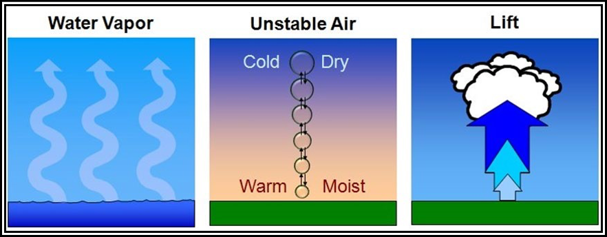
Figure . Necessary Ingredients for Thunderstorm Cell Formation
Thunderstorm Cell Life Cycle
A thunderstorm cell is the convective cell of a cumulonimbus cloud having lightning and thunder. It undergoes three distinct stages during its life cycle (see Figure 22-2): towering cumulus, mature, and dissipating. The total life cycle is typically about 30 minutes.
The distinguishing feature of the towering cumulus stage is a strong convective updraft. The updraft is a bubble of warm, rising air concentrated near the top of the cloud, which leaves a cloudy trail in its wake. Updraft speeds can exceed 3,000 fpm.
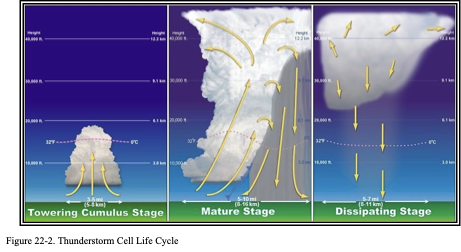
The cell transitions to the mature stage when precipitation reaches the surface. Precipitation descends through the cloud and drags the adjacent air downward, creating a strong downdraft alongside the updraft. The downdraft spreads out along the surface, well in advance of the parent thunderstorm cell, as a mass of cool, gusty air. The arc-shaped leading edge of downdraft air resembles a miniature cold front and is called a gust front. Uplift along the gust front may trigger the formation of new cells, sometimes well ahead of the parent cell. Cumulonimbus tops frequently penetrate into the lower stratosphere as an overshooting top, where strong winds aloft distort the cloud top into an anvil shape. Weather hazards reach peak intensity toward the end of the mature stage.
The dissipating stage is marked by a strong downdraft embedded within the area of precipitation. Subsiding air replaces the updraft throughout the cloud, effectively cutting off the supply of moisture provided by the updraft. Precipitation tapers off and ends. Compression warms the subsiding air and the relative humidity drops. The convective cloud gradually vaporizes from below, leaving only a remnant anvil cloud.
Thunderstorm Types
There are three principal thunderstorm types: single-cell, multicell (cluster and line), and supercell. All thunderstorms are hazardous to aircraft.
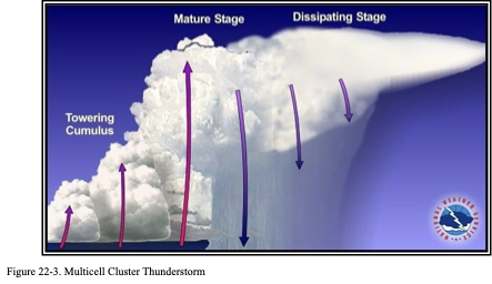
A single-cell or common (also called ordinary-cell) thunderstorm consists of only one cell. This type of thunderstorm often develops on warm and humid summer days. These cells may be severe and produce hail and microburst winds. Its life cycle was covered in the previous section. It is easily circumnavigated by pilots, except at night or when embedded in other clouds. Single-cell thunderstorms are rare; almost all thunderstorms are multicell. A multicell cluster thunderstorm (see Figure 22-3 and Figure 22-4) consists of a cluster of cells at various stages of their life cycle. With an organized multicell cluster, as the first cell matures, it is carried downwind, and a new cell forms upwind to take its place. A multicell cluster may have a lifetime of several hours (or more). New cells will continue to form as long as the three necessary ingredients exist (see Section 22.2). Individual cells within the cluster may move in one direction while the whole system moves in another. It can cover large areas and its persistence makes it a bit tougher to circumnavigate than a single-cell thunderstorm. An area of multicell cluster thunderstorms can be like a minefield for air traffic.
Sometimes thunderstorms will form in a narrow band or squall line that can extend laterally for hundreds of miles. Often it develops on or ahead of a cold front in moist, unstable air, but it may develop in unstable air far removed from any front. New cells continually re-form at the leading edge of the system with rain, and sometimes hail, following behind. Sometimes storms, which comprise the line, can be supercells. The line can persist for many hours (or more) as long as the three necessary ingredients continue to exist (see Section 22.2). These squall lines are the thunderstorm type which presents the most effective barrier to air traffic because the line is usually too tall to fly over, too dangerous to fly through or under, and difficult to circumnavigate. About 25 percent of all tornadoes in the United States are spawned by squall lines.
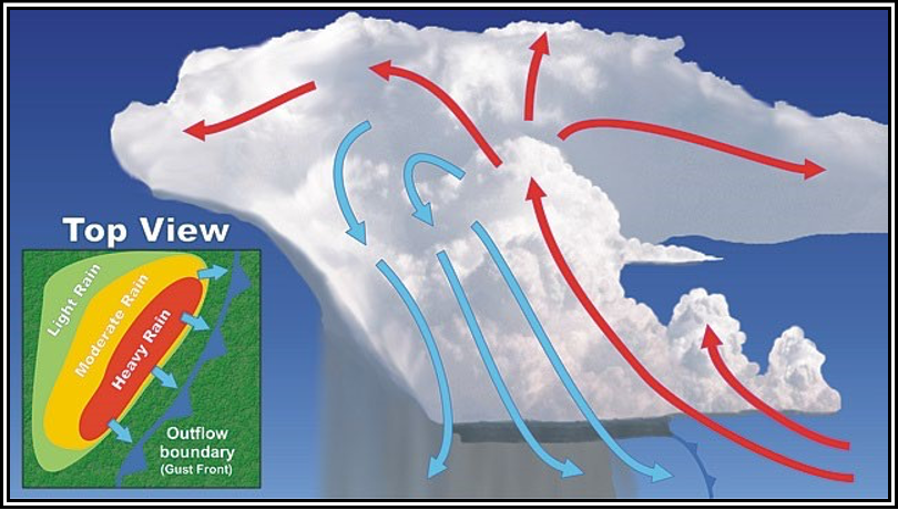
Figure 22-4. Multicell Line Thunderstorm
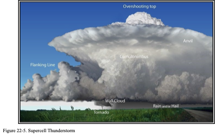
A supercell thunderstorm (see Figure 22-5) is an often dangerous, long-lived convective storm that consists primarily of a single, quasi-steady rotating updraft that persists for an extended period of time. It has a very organized internal structure that enables it to produce especially dangerous weather for pilots who encounter them. Updraft speeds may reach 9,000 fpm (100 kt). This allows hazards to be magnified to an even greater degree. Nearly all supercells produce severe weather (e.g., large hail or damaging wind) and about 25 percent produce a tornado. A supercell may persist for many hours (or longer). New cells will continue to form as long as the three necessary ingredients exist (see Section 22.2). A supercell’s size and persistence make it a bit tougher to circumnavigate than a single-cell thunderstorm. Also, multicell clusters and lines may have supercells incorporated as part of the system as well.
Factors that Influence Thunderstorm Motion
A thunderstorm is a process, not a solid object or block of wood. Storm motion equals the combined effects of both advection and propagation (see Figure 22-6). Advection is the component of storm motion due to individual cells moving with the average wind throughout the vertical depth of the cumulonimbus cloud. The wind at FL180 (500 mb) usually provides a good approximation. Propagation is the component of storm motion due to old cell dissipation and the new cell development. Storm motion may deviate substantially from the motion of the individual cells, which comprise the storm.
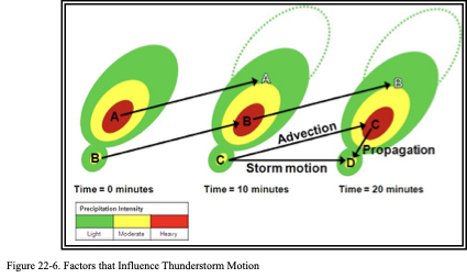
Individual cells that comprise the storm move northeast (advection), but dissipate and are replaced by new cells (propagation). Storm motion equals the combined effects of both advection and propagation.
Thunderstorm Terminology
Anvil. The flat, spreading top of a cumulonimbus cloud, often shaped like an anvil. Thunderstorm anvils may spread hundreds of miles downwind from the thunderstorm itself, and sometimes may spread upwind. Bow Echo. A radar echo that is linear but bent outward in a bow shape.
Derecho. A widespread, long-lived, straight-line windstorm that is associated with a fast-moving band of severe thunderstorms.
Downdraft. A small-scale column of air that rapidly sinks toward the ground, usually accompanied by precipitation as in a shower or thunderstorm. A microburst is the result of a strong downdraft.
Gust Front. The leading edge of gusty surface winds from thunderstorm downdrafts; sometimes associated with a shelf cloud or roll cloud. May also be referred to as a gustnado or outflow boundary.
Mesoscale Convective System (MCS). A complex of multiple thunderstorms that becomes organized on a scale larger than the individual thunderstorms but smaller than extratropical cyclones, and normally persists for several hours or more.
Roll Cloud. A low, horizontal tube-shaped arcus cloud associated with a thunderstorm gust front. Roll clouds are relatively rare; they are completely detached from the thunderstorm base or other cloud features, thus differentiating them from the more familiar shelf clouds.
Severe Thunderstorm. A thunderstorm that produces hail with a diameter of 1 in (U.S. quarter size) or larger, convective winds of 50 kt (58 mph) or greater, and/or tornadoes.
Shelf Cloud. A low, horizontal wedge-shaped cloud associated with a thunderstorm gust front. Unlike a roll cloud, a shelf cloud is attached to the base of the parent cloud above it, which is usually a thunderstorm.
Updraft. A small-scale current of rising air. If the air is sufficiently moist, then the moisture condenses to become a cumulus cloud or an individual tower of a towering cumulus or cumulonimbus.
Hazards
All thunderstorms have conditions that are hazards to aviation. These hazards occur in numerous combinations. While not every thunderstorm contains all hazards, it is not possible to visually determine which hazards a thunderstorm contains. Hazards include: low ceiling and visibility, lightning, adverse winds, downbursts, turbulence, icing, hail, rapid altimeter changes, static electricity, tornadoes, and engine water ingestion.
Low Ceiling and Visibility
Generally, visibility is near zero within a thunderstorm cloud. Ceiling and visibility also may be restricted in precipitation and dust between the cloud base and the ground. The restrictions create the same problem as all ceiling and visibility restrictions, but the hazards are increased when associated with the other thunderstorm hazards of turbulence, hail, and lightning that make precision instrument flying virtually impossible.
Lightning
Every thunderstorm produces lightning and thunder by definition. Lightning is a visible electrical discharge produced by a thunderstorm. The discharge may occur within or between clouds, between a cloud and air, between a cloud and the ground, or between the ground and a cloud.
Lightning can damage or disable an aircraft. It can puncture the skin of an aircraft, and it can damage communications and electronic navigational equipment. Lightning has been suspected of igniting fuel vapors causing an explosion; however, serious accidents due to lightning strikes are extremely rare. Nearby lightning can blind the pilot, rendering the pilot momentarily unable to navigate either by instrument or by visual reference. Nearby lightning can also induce permanent errors in the magnetic compass. Lightning discharges, even distant ones, can disrupt radio communications on low and medium frequencies. Though lightning intensity and frequency have no simple relationship to other storm parameters, severe storms, as a rule, have a high frequency of lightning.
Downburst and Microburst
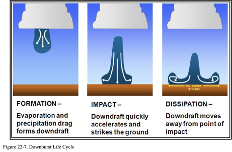
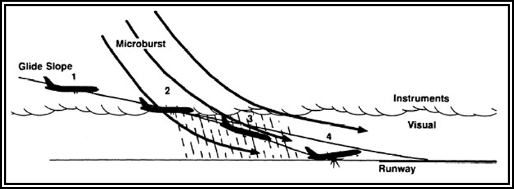
The downward moving column of air in a typical thunderstorm is large. Convective clouds, shower cells, and thunderstorm cells sometimes produce intense downdrafts called downbursts that create strong, often damaging winds and wind shear. Downbursts (see Figure 22-7) can create hazardous conditions for pilots and have been responsible for many LLWS accidents. Smaller, shorter-lived downbursts are called microbursts.
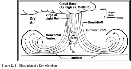
A microburst is a small-scale, intense downdraft that, when reaching the surface, spreads outward, symmetrically (see Figure 22-9) or asymmetrically (see Figure 22-10), in all directions from the downdraft center. It is the most severe type of wind shear. Microburst activity may be indicated by an intense rain shaft at the surface, but virga (i.e., streaks of precipitation falling from a thunderstorm cloud but not reaching the ground) at the cloud base and/or a ring of blowing dust is sometimes the only visible clue (see Figure 22-11). A typical microburst has a horizontal diameter of less than 2.5 mi and a nominal depth of 1,000 ft. The lifespan of a microburst is about 5 to 15 minutes, during which time it can produce downdrafts of up to 6,000 fpm; increasing headwind and headwind losses of 30 to 90 kt, seriously degrading performance. It can also produce strong turbulence and hazardous wind direction changes
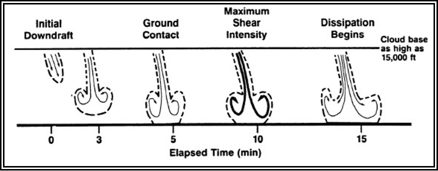
Figure . Illustration of the Evolution of a Microburst
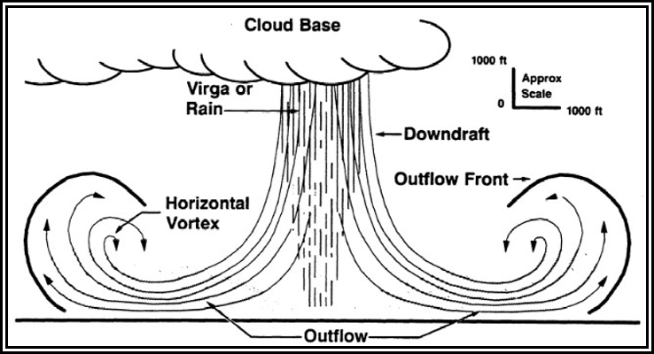
Figure . Illustration of a Symmetric Microburst
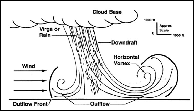
Figure . Illustration of an Asymmetric Microburst
More than one microburst can occur in the same weather system. Pilots are therefore cautioned to be alert for additional microbursts if one has already been encountered or observed. If several microbursts are present, a series of horizontal vortices can form near the ground due to several microbursts being embedded in one another (see Figure 22-12). Conditions associated with these vortices may produce very powerful updrafts and roll forces in addition to downdrafts.
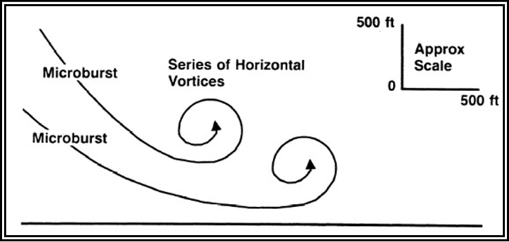
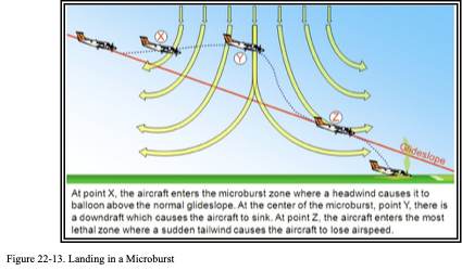
Figure . Illustration of a Series of Vortices Due to Microbursts Being Embedded in One Another A downburst or microburst is dangerous to aircraft when climbing from takeoff or approaching to land. During these phases, the aircraft is operating at slow speeds. A major change of wind velocity can lead to loss of lift and a crash. During landing, if the pilot has reduced power and lowered the nose in response to the headwind shear (see Figure 22-13) this leaves the aircraft in a nose-low, power-low configuration when the tailwind shear occurs, which makes recovery more difficult. It can cause the airplane to stall or land short of the runway.
Pilots should be alert for indications of a microburst early in the approach phase, and ready to initiate a missed approach at the first indication. However, it may be impossible to recover from a microburst encounter at low altitude.
Pilots should be aware of asymmetrical microbursts , since a significant airspeed increase may not occur upon entering the outflow, or may be much less than the subsequent airspeed loss experienced when exiting the microburst.
It is vital for pilots to recognize that some microbursts cannot be successfully escaped with any known techniques. Some wind shears that are within the performance capability of the aircraft have caused accidents.
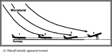
Encounter During Takeoff—After Lift-Off In previous accidents studied, the airplane encountered an increasing tailwind shear shortly after lifting off the runway (see Figure 22-14). For the first 5 seconds after lift-off, the takeoff appeared normal, but the airplane crashed off the end of the runway about 20 seconds after lift-off.
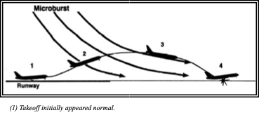
(1) Takeoff initially appeared normal.
(2) Wind shear encountered just after lift-off.
(3)Airspeed decrease resulted in pitch attitude reduction.
(4)Aircraft crashed off departure end of runway 20 seconds after lift-off
Figure . Wind Shear Encounter During Takeoff After Lift-Off
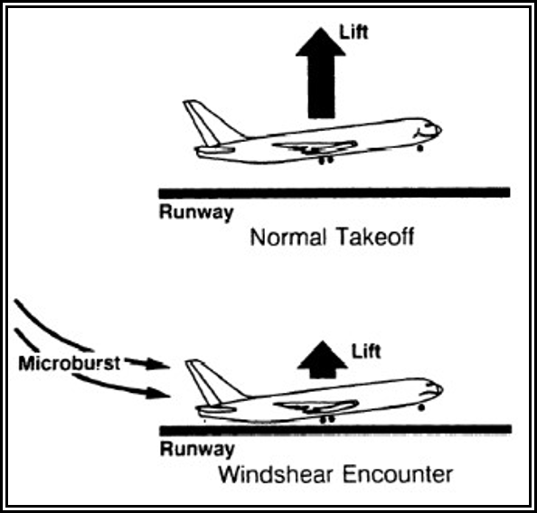
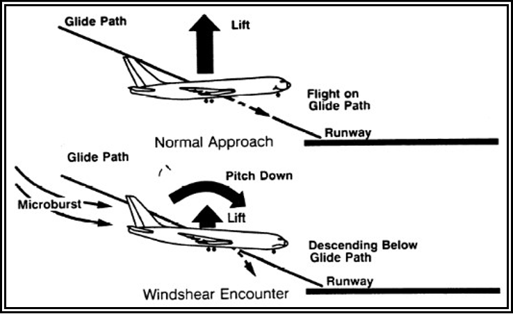
In many events involving after-lift-off wind shear encounters, early trends in airspeed, pitch attitude, vertical speed, and altitude appeared normal. In this example, the airplane encountered wind shear before stabilized climb was established, which caused difficulty in detecting onset of shear. As the airspeed decreased, pitch attitude was reduced to regain trim airspeed (see Figure 22-15). By reducing pitch attitude, available performance capability was not utilized and the airplane lost altitude. As terrain became a factor, recovery to initial pitch attitude was initiated. This required unusually high stick force (up to 30 lb of pull may be needed on some airplanes). Corrective action, however, was too late to prevent ground contact since the downward flightpath was well established. Reducing pitch attitude to regain lost airspeed, or allowing attitude to decrease in response to lost airspeed, is the result of past training emphasis on airspeed control. Successful recovery from an inadvertent wind shear encounter necessitates maintaining or increasing pitch attitude and accepting lower-than-usual airspeed. Unusual and unexpected stick forces may be needed to counter natural airplane pitching tendencies due to airspeed and lift loss.
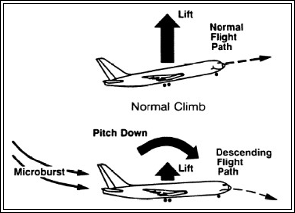
Microburst reduces airspeed and lift at normal attitude, which results in pitch-down tendency to regain airspeed.
Figure . Wind Shear Effects on Flightpath To counter the loss of airspeed and lift resulting from wind shear, pitch attitude must not be allowed to fall below the normal range. Only by properly controlling pitch attitude and accepting reduced airspeed can flightpath degradation be prevented (see Figure 22-16). Once the airplane begins to deviate from the intended flightpath and high descent rates develop, it takes additional time and altitude to change flightpath direction.
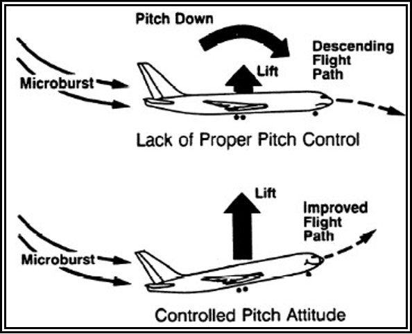
Control of pitch attitude and acceptance of reduced airspeed results in improved flightpath.
Figure . Pitch Control Effects on Flightpath
Only 5 to 15 seconds may be available to recognize and respond to a wind shear encounter . Therefore, it is of great importance that a wind shear encounter be recognized as soon as possible.
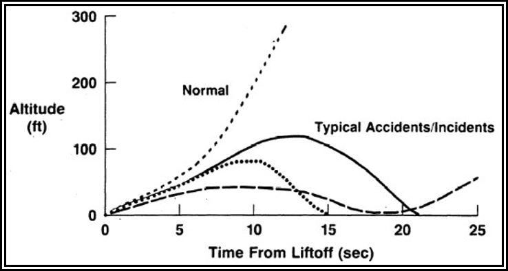
Takeoff initially appeared normal. Additional time is needed to arrest descent. Result: Only 5 to 15 seconds may be available for recognition and recovery.
Figure . Time Available to Respond to Wind Shear Encounter
Encounter During Takeoff—On Runway Analysis of a typical accident where an increasing tailwind shear was encountered during takeoff ground roll showed that initial indications appeared normal (see Figure 22-18). Due to the increasing tailwind shear, however, the airplane did not reach rotation speed (VR) until nearing the end of the runway. As the airplane lifted off, the tailwind continued increasing, preventing any further airspeed increase. The airplane contacted an obstacle off the departure end of the runway.
- Takeoff initially appeared normal.
- Airspeed buildup slowed due to wind shear.
- Airplane reached Vr near end of runway, lifted off but failed to climb.
- Airplane contacted obstacle off departure end of runway.
Figure . Wind Shear Encounter During Takeoff on Runway Less-than-normal airspeed, due to wind shear encounter, resulted in reduced available lift at normal takeoff attitude (see Figure 22-19). In turn, the inability to lift off soon enough to clear obstacles resulted.
Microburst reduces airspeed and lift at normal attitude that results in inability to lift off.
Figure . Wind Shear Effects on Lift-Off
An additional factor is the difficulty of recognizing deteriorating airplane performance. Timely recognition of a wind shear encounter on the runway may be difficult since the only indication may be a slower-than-normal airspeed increase. The presence of gusts may mask abnormal airspeed buildup. Time available to respond effectively to a wind shear may be as little as 5 seconds from the initial encounter. If there is insufficient runway left to accelerate to normal takeoff speed, and inadequate runway to stop, lift-off and safe climb may require rotation at speeds less than VR. In this case, additional pitch attitude may be needed to achieve sufficient lift (see Figure 22-20). In traditional training, crews are frequently cautioned not to rotate at speeds less than VR to avoid high pitch attitudes that could result in aft body contact. In a wind shear encounter, rotation toward normal takeoff pitch attitude at lower-than-normal airspeed may be needed to lift off in the remaining runway. This may result in aft body contact. To deal with an inadvertent wind shear encounter, the pilot should be prepared to apply techniques that differ from those ordinarily used
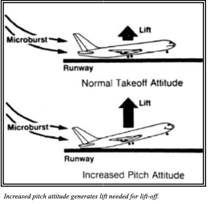
Figure . Pitch Attitude Effects on Lift-Off
Encounter on Approach Analysis of a typical wind shear encounter on approach provided evidence of an increasing downdraft and tailwind along the approach flightpath (see Figure 22-21). The airplane lost airspeed, dropped below the target glidepath, and contacted the ground short of the runway threshold
- Approach initially appeared normal.
- Increasing downdraft and tailwind encountered at transition.
- Airspeed decrease combined with reduced visual cues resulted in pitch attitude reduction.
- Airplane crashed short of approach end of runway.
Figure . Wind Shear Encounter During Approach
Reduced airspeed, as the airplane encountered the wind shear, resulted in decreased lift. This loss of lift increased the descent rate . The natural nose-down pitch response of the airplane to low airspeed caused additional altitude loss. Pitch attitude increase and recovery initiation were not used soon enough to prevent ground contact.
Lack of timely and appropriate response—affected by weather conditions, inadequate crew coordination, and limited recognition time—was a significant factor in delaying recovery initiation. Gradual application of thrust during approach may have masked the initial decreasing airspeed trend. Poor weather conditions caused increased workload and complicated the approach. Transition from instruments to exterior visual references may have detracted from instrument scan. Inadequate crew coordination may have resulted in a failure to be aware of flightpath degradation. A stabilized approach with clearly defined callouts is essential to aid in the recognition of unacceptable flightpath trends and the need to initiate recovery.
Microburst reduces airspeed and lift at normal attitude that results in pitch-down tendency to regain airspeed.
Wind Shear Effects on Flightpath on Approach
Wind Shear Effects on Airplanes and Systems
Several terms are used when discussing low-altitude wind variations with respect to aviation. These terms are defined as follows:
- Increasing Headwind Shear: Wind shear in which headwind increases, causing an airspeed increase.
- Decreasing Headwind Shear: Wind shear in which headwind decreases, causing an airspeed decrease.
- Decreasing Tailwind Shear: Wind shear in which tailwind decreases, causing an airspeed increase.
- Increasing Tailwind Shear: Wind shear in which tailwind increases, causing an airspeed decrease.
Headwind/Tailwind Shear Response
The various components of wind shear have unique effects on airplane performance. In addition, the magnitude of the shear depends on the flightpath through the microburst.
An increasing headwind (or decreasing tailwind) shear increases indicated airspeed and thus increases performance. The airplane will tend to pitch up to regain trim airspeed. An additional consideration is that this type of shear may reduce normal deceleration during flare, which could cause overrun.
Any rapid or large airspeed increase, particularly near convective weather conditions, should be viewed as a possible indication of a forthcoming airspeed decrease. Thus, a large airspeed increase may be reason for discontinuing the approach. However, since microbursts are often asymmetric and the headwind may not always be present, headwind shears are not to be relied upon to provide early indications of subsequent tailwind shears.
In contrast to shears that increase airspeed, an increasing tailwind (or decreasing headwind) shear will decrease indicated airspeed and performance capability. Due to airspeed loss, the airplane may tend to pitch down to regain trim speed.
Vertical Wind Shear Response
Vertical winds exist in every microburst and increase in intensity with altitude. Such winds usually reach peak intensity at heights greater than 500 ft above the ground. Downdrafts with speeds greater than 3,000 fpm can exist in the center of a strong microburst. The severity of the downdraft the airplane encounters depends on both the altitude and lateral proximity to the center of the microburst. Perhaps more critical than sustained downdrafts, short duration reversals in vertical winds can exist due to the horizontal vortices associated with microbursts. This is shown in Figure 22-23 below
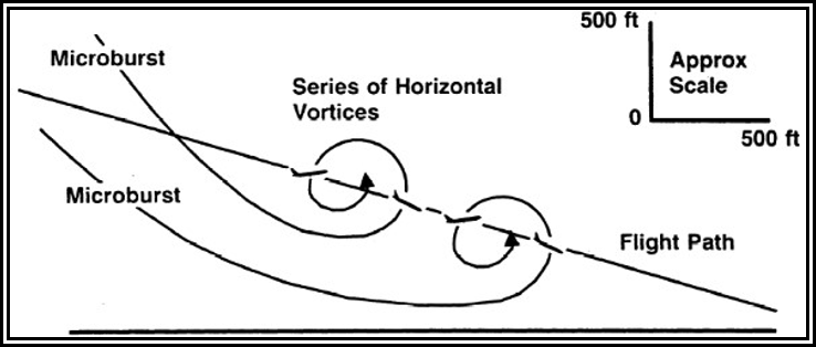
Rapid updraft/downdraft variations due to horizontal vortices can cause uncommanded pitch changes and may result in momentary stick shaker activation well above normal stick shaker speeds.
Figure . Illustration of an Encounter with Microburst Horizontal Vortices
An airplane flying through horizontal vortices as shown in Figure 22-23 experiences alternating updrafts and downdrafts causing pitch changes without pilot input. These vertical winds result in airplane angle-of-attack fluctuations which, if severe enough, may result in momentary stick shaker actuation or airframe shudder at speeds well above normal.
Convective Turbulence
See Section for information on convective turbulence.
Convective Icing
See Section for information on convective icing.
Hail
See Section for information on hail.
| EF-Rating | Class | 3-Second Wind Gust | Description | Relative Frequency | |
| mph | km/h | ||||
| EF-0 | Weak | 65–85 | 105–137 | Gale | 53.5% |
| EF-1 | Weak | 86–110 | 138–177 | Weak | 31.6% |
| EF-2 | Strong | 111–135 | 178–217 | Strong | 10.7% |
| EF-3 | Strong | 136–165 | 218–266 | Severe | 3.4% |
| EF-4 | Violent | 166–200 | 267–322 | Devastating | 0.7% |
| EF-5 | Violent | >200 | >322 | Incredible | <0.1% |
| Note: The EF Scale is a set of wind estimates (not measurements) based on damage. The 3-second gust is not the same wind as in METAR/SPECI surface observations, which is a 2-minute average. Note: Confirmed tornadoes with no reported damage (i.e., those that remain in open fields) are always rated EF-0. | |||||
Rapid Altimeter Changes
Pressure usually falls rapidly with the approach of a thunderstorm. Pressure then usually rises sharply with the onset of the first gust and arrival of the cold downdraft and heavy rain, falling back to normal as the thunderstorm passes. This cycle of pressure change may occur in 15 minutes. If the pilot does not receive a corrected altimeter setting, the altimeter may be more than 100 ft in error.
Static Electricity
Static electricity (a steady, high level of noise in radio receivers) is caused by intense corona discharges from sharp metallic points and edges of flying aircraft. It is encountered often in the vicinity of thunderstorms. When an aircraft flies through clouds, precipitation, or a concentration of solid particles (e.g., ice, sand, or dust), it accumulates a charge of static electricity. The electricity discharges onto a nearby surface or into the air, causing a noisy disturbance at lower frequencies.
The corona discharge is weakly luminous and may be seen at night. Although it has a rather eerie appearance, it is harmless. It was named “St. Elmo’s Fire” by Mediterranean sailors, who saw the brushy discharge at the top of ship masts.
Tornado
A tornado is a violently rotating column of air in contact with the ground, either pendant from a cumuliform cloud or underneath a cumuliform cloud, and often (but not always) visible as a funnel cloud. The most violent thunderstorms draw air into their cloud bases with great force. If the incoming air has any initial rotating motion, it often forms an extremely concentrated vortex from the surface well into the cloud. Meteorologists have estimated that wind in such a vortex can exceed 200 kt; pressure inside the vortex is quite low. The strong winds gather dust and debris, and the low pressure generates a funnel-shaped cloud extending downward from the cumulonimbus base. If the cloud does not reach the surface, it is a “funnel cloud;” if it touches a land surface, it is a “tornado;” and if it touches water, it is a “waterspout.” When tornadoes do occur without any visible funnel cloud, debris at the surface is usually the indication of the existence of an intense circulation in contact with the ground.
Tornadoes can occur almost anywhere in the world, but are most common in the central and eastern United States during spring and autumn months. They typically last only a few minutes and travel a few miles, but can persist much longer (e.g., more than 90 minutes) and track much farther (e.g., more than 100 mi), in extreme cases.
On a local scale, the tornado is the most intense of all atmospheric circulations. Its vortex is typically a few hundred yards in diameter, but can range in width from less than 10 yards (yd) to over 2 mi. Wind speeds are typically estimated on the basis of wind damage using the Enhanced Fujita (EF) Scale . Table 22-1. Enhanced Fujita Scale for Tornado Damage.
Tornadoes occur with both isolated and squall line thunderstorms. However, over 80 percent of all tornadoes in the United States are produced by supercell thunderstorms. Multiple tornado occurrences associated with a particular large-scale weather system is termed a “tornado outbreak.” On rare occasions, one supercell can produce multiple tornadoes over many hours. In addition, families of tornadoes have also been observed as appendages of the main cloud extending several miles outward from the area of lightning and precipitation. Thus, any cloud connected to a severe thunderstorm may contain hidden vortices.
An aircraft entering a tornado vortex is almost certain to suffer loss of control and structural damage. Since the vortex extends well into the cloud, any pilot inadvertently caught on instruments in a thunderstorm could encounter a hidden vortex.
Engine Water Ingestion
Turbine engines have a limit on the amount of water they can ingest. Updrafts are present in many thunderstorms, particularly those in the developing stages. If the updraft velocity in the thunderstorm approaches or exceeds the velocity of the falling raindrops, very high concentrations of water may occur. It is possible that these concentrations can be in excess of the quantity of water that turbine engines are designed to ingest. Therefore, severe thunderstorms may contain areas of high water concentration, which could result in flameout and/or structural failure of one or more engines.
Thunderstorm Avoidance
Airborne Weather Avoidance Radar (Aircraft Radar)
Airborne weather avoidance radar is, as the name implies, for avoiding severe weather—not for penetrating it. Whether to fly into an area of radar echoes depends on echo intensity, spacing between the echoes, and the capabilities of the pilot and the aircraft. The ability of airborne weather radar to detect weather phenomena is limited in both direction and range. Some airborne radars are fitted with a turbulence display mode, which is based on the Doppler effect. These Doppler radars can detect turbulence associated with precipitation (sometimes referred to as wet precipitation), but these radars are unable to detect CAT. The radar display also does not provide assurance of avoiding instrument weather conditions from clouds and fog. A phenomenon called attenuation (see Section 15.2.5) may exist when a cell absorbs or reflects all of the radio signals sent by the radar system . Attenuation may prevent the radar from detecting additional cells that might lie behind the first cell. This is sometimes referred to as a radar “shadow.” For aircraft equipped with airborne weather radar, pilots are expected to be familiar with the operating techniques and limitations of the specific system.
It is important to note that while hail always gives a radar echo, it may fall several miles from the nearest visible cloud, and hazardous turbulence may extend to as much as 20 mi from the echo edge.
Thunderstorm Avoidance Guidance
Never regard any thunderstorm lightly, even when radar observers report the echoes are of light intensity. Avoiding thunderstorms is the best policy. The following is guidance for avoiding thunderstorms:
- Do not land or take off in the face of an approaching thunderstorm. A sudden gust front of low-level turbulence could cause loss of control.
- Do not attempt to fly under a thunderstorm, even if you can see through to the other side. Turbulence and wind shear under the storm could be hazardous.
- Do not attempt to fly under the anvil of a thunderstorm. There is a potential for severe and extreme CAT.
- Do not fly without airborne radar into a cloud mass containing scattered embedded thunderstorms. Scattered thunderstorms not embedded usually can be visually circumnavigated.
- Do not trust the visual appearance to be a reliable indicator of the turbulence inside a thunderstorm.
- Do not assume that ATC will offer radar navigation guidance or deviations around thunderstorms.
- Use data-linked weather radar (i.e., NEXRAD) mosaic imagery as the sole means for negotiating a path through a thunderstorm area (tactical maneuvering).
- Remember that the data-linked NEXRAD mosaic imagery shows where the weather was, not where the weather is. The weather conditions may be 15 to 20 minutes older than the age indicated on the display.
- Listen to chatter on the ATC frequency for PIREPs and other aircraft requesting to deviate or divert.
- Ask ATC for radar navigation guidance or to approve deviations around thunderstorms, if needed.
- Use data-linked weather NEXRAD mosaic imagery (e.g., FIS-B) for route selection to avoid thunderstorms entirely (strategic maneuvering).
- Advise ATC, when switched to another controller, that you are deviating for thunderstorms before accepting to rejoin the original route.
- Ensure that after an authorized weather deviation, before accepting to rejoin the original route, that the route of flight is clear of thunderstorms.
- Avoid by at least 20 mi any thunderstorm identified as severe or giving an intense, heavy, or extreme radar echo. This is especially true under the anvil of a large cumulonimbus. Such echoes should be separated by at least 40 mi before flying between echoes. Separation distances may be reduced for avoiding weaker echoes.
- Circumnavigate the entire area if more than half the area is covered by thunderstorms.
- Vivid and frequent lightning indicates the probability of a severe thunderstorm.
- Regard as extremely hazardous any thunderstorm with tops 35,000 ft or higher, whether the top is visually sighted or determined by radar.
- Give a PIREP for the flight conditions.
- Divert and wait out the thunderstorms on the ground if unable to navigate around an area of thunderstorms.
If unable to avoid penetrating a thunderstorm, the following is guidance for before entering the storm:
- Tighten the safety belt, put on the shoulder harness (if installed), and secure all loose objects.
- Plan and hold the course to take the aircraft through the storm in a minimum time.
- To avoid the most critical icing, establish a penetration altitude below the freezing level or above the level of 15 ºC.
- Verify that pitot heat is on and turn on carburetor heat or jet engine anti-ice. Icing can be rapid at any altitude and cause almost instantaneous power failure and/or loss of airspeed indication.
- Establish power settings for turbulence penetration airspeed recommended in the aircraft manual.
- Turn up cockpit lights to highest intensity to lessen temporary blindness from lightning.
- If using automatic pilot, disengage Altitude Hold Mode and Speed Hold Mode. The automatic altitude and speed controls will increase maneuvers of the aircraft; thus, increasing structural stress.
- If using airborne radar, tilt the antenna up and down occasionally. This will permit the detection of other thunderstorm activity at altitudes other than the one being flown.
- Keep eyes on the flight instruments. Looking outside the cockpit can increase danger of temporary blindness from lightning.
- Do not change power settings; maintain settings for the recommended turbulence penetration airspeed.
- Maintain constant attitude. Allow the altitude and airspeed to fluctuate.
Do not turn back once in the thunderstorm. A straight course through the storm most likely will get the aircraft out of the hazards most quickly. In addition, turning maneuvers increase stress on the aircraft.


