Introduction
Strictly speaking, the Arctic is the region shown in Figure 21-1, which lies within the Arctic Circle (66.5° N latitude). However, it is loosely defined as the northern regions, in general. This chapter includes Alaska weather, even though much of Alaska lies south of the Arctic Circle.
As an introduction to Arctic weather, this chapter surveys climate, air masses, and fronts of the Arctic, and introduces some Arctic weather peculiarities.
This chapter also covers Arctic aviation weather hazards.
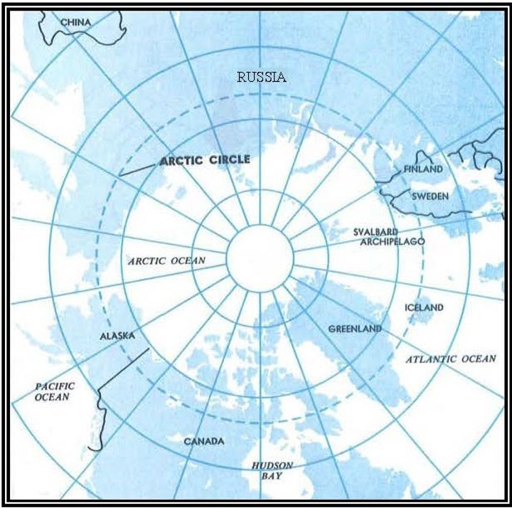
Figure 21-1. The Arctic Circle
Climate, Air Masses, and Fronts
There are a number of factors that influence Arctic climate. Climate of any region, especially in the Arctic, is largely determined by the amount of energy received from the Sun; however, local characteristics of the area, such as mountains and ice cover, also influence climate.
Long Days and Nights
A profound seasonal change in length of day and night occurs in the Arctic because of the Earth’s tilt and its revolution around the Sun. Any point north of the Arctic Circle has autumn and winter days when the Sun stays below the horizon all day and has spring and summer days with 24 hours of sunshine when the Sun stays above the horizon. The number of these days increases toward the North Pole; there the Sun stays below the horizon for 6 months and shines continuously during the other 6 months.
Twilight in the Arctic is prolonged because of the shallow angle of the Sun below the horizon. In more northern latitudes, it persists for days when the Sun remains just below the horizon. This abundance of twilight often makes visual reference possible at night.
Land and Water
Figure shows the water and the land distribution in the Arctic. Arctic mountain ranges are effective barriers to air movement. Large masses of air stagnate over inland continental areas; thus, Arctic continental areas are air mass source regions.
A large portion of the Arctic Ocean is covered throughout the year by a deep layer of ice, known as the permanent ice pack. This ice pack goes through a seasonal cycle where ice melts in the spring and summer and increases in the autumn and winter. Even though a large portion of the Arctic Ocean is ice-covered through much of the year, the ice and the water below contain more heat than the surrounding cold land, thus moderating the climate. Oceanic and coastal areas have a milder climate during winter and a cool climate during summer. As opposed to large water bodies, large land areas show a more significant seasonal temperature variation.
Temperature
As one would expect, the Arctic is very cold in winter, but due to local terrain and the movement of pressure systems, occasionally some areas are surprisingly warm. During winter, coastal areas are warmer than the interior. During summer, interior areas are pleasantly warm due to many hours of sunshine, while coastal areas have relatively short, cool summers due to their proximity to water.
Clouds and Precipitation
Cloudiness over the Arctic is at a minimum during winter due to the ice pack being more widespread. Spring brings many cloudy days, with cloudiness reaching a maximum in summer and autumn when a portion of the sea ice melts and exposes additional water in the Arctic Ocean.
During summer afternoons, scattered cumulus clouds forming over the interior occasionally grow into thundershowers. These thundershowers move generally from northeast to southwest in the polar easterlies, which is opposite the general movement in the mid-latitudes.
During the winter, polar lows can form over the open ocean. Polar lows are small, intense low-pressure systems that can develop rapidly when cold air flows over warm water. They produce severe weather, strong surface winds, and heavy precipitation. Polar lows dissipate quickly once they move over land.
Precipitation in the Arctic can vary drastically per region, but is generally light. Some areas are known as polar deserts. In winter, the only precipitation received in the Arctic is snow, while in summer precipitation falls mostly in the form of snow over ice caps and oceanic areas and rain over interior areas. Annual amounts of precipitation over the ice pack and along the coastal areas tend to be less than the interior areas.
Wind
Typically, Arctic winds are light. Strong winds occur more often along the coastal areas in autumn and winter. Wind speeds are generally light in the continental interior throughout the entire year, but are normally at their strongest during summer and autumn.
Air Masses—Winter
In winter, air masses form over the expanded ice pack and adjoining snow-covered land areas. These air masses are characterized by very cold surface air, very low humidity, and strong low-level temperature inversions. Occasionally, air from unfrozen ocean areas flows northward over the Arctic. These intrusions of moist, cold air account for most of the infrequent wintertime cloudiness and precipitation in the Arctic.
Air Masses—Summer
During the summer, the top layer of the Arctic permafrost layer melts, leaving very moist ground, and the open water areas of the Polar Basin increase markedly. Thus, the entire area becomes more humid, relatively mild, and semi-maritime in character. The largest amounts of cloudiness and precipitation occur inland during the summer months.
Fronts
Occluded fronts are the rule. Weather conditions with occluded fronts are much the same in the Arctic as elsewhere: low clouds, precipitation, poor visibility, and sudden fog formation. Fronts are much more frequent over coastal areas than over the interior.
Arctic Peculiarities
Several Arctic phenomena are peculiar to the region.
Effects of Temperature Inversion
The Arctic experiences frequent low-level temperature inversions, which occur when temperature increases with height (i.e., cold air settled near the ground with warm air directly above). Inversions can slow down surface winds and trap pollutants, creating smoggy and hazy conditions that persist until the inversion ends. In addition, light rays are bent as they pass at low angles through the inversion, creating an effect known as looming, which is a form of mirage that causes objects beyond the horizon to appear above the horizon. These low-level inversion mirages distort the shape of the Sun, Moon, and other objects.
Light Reflection by Snow-Covered Surfaces
Much more light is reflected by snow-covered surfaces than by darker surfaces. Snow often reflects Arctic sunlight sufficiently to blot out shadows, thus decreasing the contrast between objects. Dark, distant mountains may be easily recognized, but a crevasse normally directly in view may be undetected due to lack of contrasts.
Light from Celestial Bodies
Illumination from the Moon and stars is much more intense in the Arctic than in lower latitudes. Even illumination from the stars creates visibility far beyond that found elsewhere. Only under heavy overcast skies does the night darkness in the Arctic begin to approach the degree of darkness in lower latitudes.
Arctic Weather Hazards
Weather hazards include visibility-restricting phenomena such as blowing snow, icing, frost, and lack of contrast (e.g., whiteout).
Fog and Ice Fog
Fog occurs when water droplets or ice particles are suspended in the air at the Earth’s surface. Water-droplet fog occurs in coastal areas during the summer. Ice fog (also called ice-crystal fog, frozen fog, frost fog, frost flakes, air hoar, rime fog, and pogonip) is a type of fog formed by direct freezing of supercooled water droplets. Ice fog is composed of suspended particles of ice, partly ice crystals 20 to 100 microns in diameter, but chiefly (especially when dense) ice particles about 12 to 20 microns in diameter. It occurs at very low temperatures and usually in clear, calm weather in high latitudes. The Sun may cause the appearance of a halo. Effective visibility is reduced considerably more when looking toward the Sun. Ice fog is rare at temperatures warmer than -30 °C, and increases in frequency with decreasing temperature until it is almost always present at air temperatures of -45 °C in the vicinity of a source of water vapor. Such sources of water vapor are the open water of fast-flowing streams or of the sea, herds of animals, volcanoes, and especially products of combustion for heating, automobiles, and aircraft. At temperatures warmer than -30 °C, these sources can cause steam fog of liquid water droplets, which may turn into ice fog when cooled.
Blowing and Drifting Snow
Over the frozen Arctic Ocean and along the coastal areas, blowing snow, drifting snow, and strong winds are common hazards during autumn and winter. Blowing snow is wind-driven falling or accumulated snow that reduces surface visibility. Drifting snow is an uneven distribution of snowfall or snow depth caused by strong surface winds, which may occur during or after a snowfall. Drifting snow is usually associated with blowing snow. In the Arctic, because the snow is dry and fine, it can be picked up easily by light winds that raise the snow several feet off the ground, obliterating objects. A sudden increase in surface wind may cause an unlimited visibility to drop to near zero in a few minutes. This sudden loss of visibility occurs frequently without warning in the Arctic.
Frost
Frost is the formation of thin ice crystals on the ground or other surfaces on solid objects below the freezing point of water. It develops in Arctic coastal areas during spring, autumn, and winter.
Whiteout
Whiteout is a visibility-restricting phenomenon that occurs most often in the spring and autumn in the Arctic when the Sun is near the horizon. It occurs when a layer of overcast clouds overlies a snow- or ice-covered surface. Parallel rays of the Sun are broken up and diffused when passing through the cloud layer so that they strike the snow surface from many angles. The diffused light then reflects back and forth countless times between the snow and the cloud, eliminating all shadows. The result is a loss of depth perception. Buildings, people, and dark-colored objects appear to float in the air, and the horizon disappears


