Introduction
Convective clouds and precipitation pose a distinctly different flying environment than stratiform clouds and precipitation. These sharply contrasting conditions result from the atmosphere either resisting or accelerating the vertical motion of air parcels. Atmospheric stability is the property of the ambient air that either enhances or suppresses vertical motion of air parcels and determines which type of clouds and precipitation a pilot will encounter.
Using a Parcel as a Tool to Evaluate Stability
An air parcel can be used as a tool to evaluate atmospheric stability within a specified vertical column of air in the atmosphere. A parcel is selected from a specified altitude (usually the surface) and hypothetically lifted upward to a specified test altitude. As the parcel is lifted, its temperature decreases due to the expansion and latent heat effects discussed in Chapter 12, Vertical Motion and Clouds.
The parcel and the surrounding environmental air temperatures are then compared. If the lifted parcel is colder than the surrounding air, it will be denser (heavier) and sink back to its original level. In this case, the parcel is stable because it resists upward displacement. If the lifted parcel is the same temperature as the surrounding air, it will be the same density and remain at the same level. In this case, the parcel is neutrally stable. If the lifted parcel is warmer and, therefore, less dense (lighter) than the surrounding air, it will continue to rise on its own until it reaches the same temperature as its environment. This final case is an example of an unstable parcel. Greater temperature differences result in greater rates of vertical motion.
Stability Types
The stability of a column of air in the atmosphere is classified by the distribution of parcel stabilities within the column. The Earth’s surface is typically selected as the base while the top determines the column’s depth. Four unique types of atmospheric stability can be identified and are discussed in the following sections.
Absolute Stability
Absolute stability is the state of a column of air in the atmosphere when its lapse rate of temperature is less than the moist adiabatic lapse rate. This includes both isothermal and inversion temperature profiles. An air parcel lifted upward would be colder (denser) than the surrounding environmental air and would tend to sink back to its level of origin.
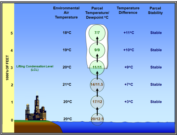
Figure. Absolute Stability Example
Neutral Stability
Neutral stability is the state of a column of air in the atmosphere in which an ascending (or descending) air parcel always has the same temperature (density) as the surrounding environmental air. If the column of air is unsaturated, then neutral stability exists when its lapse rate of temperature equals the dry adiabatic lapse rate. If the column of air is saturated, then neutral stability exists when its lapse rate of temperature equals the moist adiabatic lapse rate.

Figure. Neutral Stability Example
Absolute Instability
Absolute instability is the state of a column of air in the atmosphere when it has a superadiabatic lapse rate of temperature (i.e., greater than the dry adiabatic lapse rate). An air parcel displaced vertically would be accelerated in the direction of the displacement. The kinetic energy of the parcel would consequently increase with increasing distance from its level of origin.
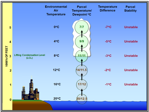
Figure. Absolute Instability Example
Conditional Instability
Conditional instability is the state of a column of unsaturated air in the atmosphere when its lapse rate of temperature is less than the dry adiabatic lapse rate, but greater than the moist adiabatic lapse rate. An air parcel lifted upward would be initially stable, but at some point above its LCL it would become unstable. The term “conditional” means the parcel must be lifted to a particular level (altitude) before it becomes unstable and rises because of its own buoyancy. The Level of Free Convection (LFC) is the level at which a parcel of air lifted dry adiabatically until saturated and moist adiabatically thereafter would first become warmer than the surrounding environmental air (i.e., unstable) in a conditionally unstable column of air in the atmosphere. The LFC is a defining feature of a conditionally unstable column of air.
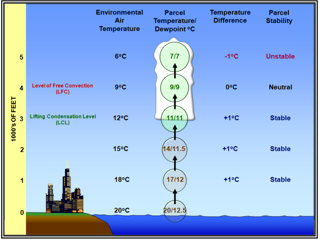
Figure. Conditional Instability Example
Summary of Stability Types
Figure below summarizes the possible atmospheric stability types.
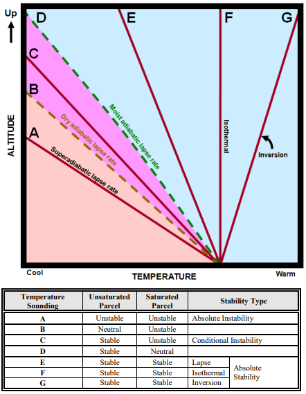
Figure. Stability Types
Processes That Change Atmospheric Stability
Changes in atmospheric stability are inversely related to temperature (density) changes with height. If temperature lapse rates increase, then stability decreases. Conversely, if temperature lapse rates decrease, then stability increases. Most of these changes occur as a result of the movement of air, but diurnal (day/night) temperature variations can play a significant role.
In the column of air on the right is less stable because its temperature lapse rate is higher.
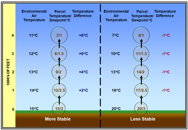
Figure. Temperature Lapse Rate Effects on Stability
Wind Effects on Stability
Wind can act to change the stability of a column of air in the atmosphere by changing the temperature lapse rate. Stability increases when wind blows colder air into the bottom of the air column (cold air advection) and/or warmer air at the top (warm air advection). Conversely, stability decreases when wind blows warmer air into the bottom of the air column and/or colder air at the top.
Vertical Air Motion Effects on Stability
A column of air in the atmosphere will become more stable when it descends (subsides). As it subsides, it becomes compressed by the weight of the atmosphere and shrinks vertically. The entire layer warms due to adiabatic compression. However, the upper part of the column sinks farther and, thus, warms more than the bottom part. This process acts to decrease the temperature lapse rate and increase stability.
Conversely, a column of air in the atmosphere will become less stable when it ascends (rises). As it rises, the rapid decrease in air density aloft causes the column to stretch out vertically. As long as the layer remains unsaturated, the entire layer cools at the dry adiabatic lapse rate. However, due to the stretching effect, air at the top of the column cools more than the air at the bottom of the column. This process acts to increase the temperature lapse rate and decrease stability.
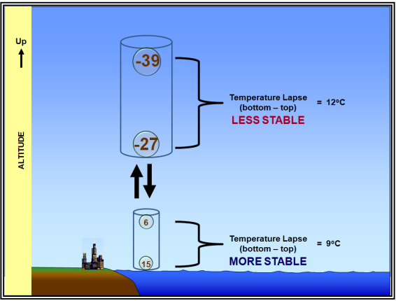
Figure. Vertical Motion Effects on Stability
A rising column of air will become less stable when air at the bottom has a higher relative humidity than air at the top. As the air moves upward, the bottom becomes saturated first and cools at the lesser moist adiabatic lapse rate. The net effect is to increase the lapse rate within the column and decrease stability. This process is called convective instability, and is associated with the development of thunderstorms.
Diurnal Temperature Variation Effects on Stability
Diurnal (day/night) temperature variations can have a significant impact on atmospheric stability. Daytime heating of the surface increases temperature lapse rates and decreases stability. Conversely, nighttime cooling of the surface decreases temperature lapse rates and increases stability. Diurnal temperature variations are most pronounced in the lower troposphere because air is a poor conductor of heat.
The magnitude of diurnal temperature (and stability) variation is primarily influenced by surface type, latitude, sky cover (e.g., clouds and pollutants), water vapor content of the air, and wind speed. Temperature variation is maximized over land, at low latitudes, with a clear sky, dry air, and light wind. Conversely, temperature variation is minimized over large bodies of water, at high latitudes, with a cloudy sky, moist air, and strong wind.
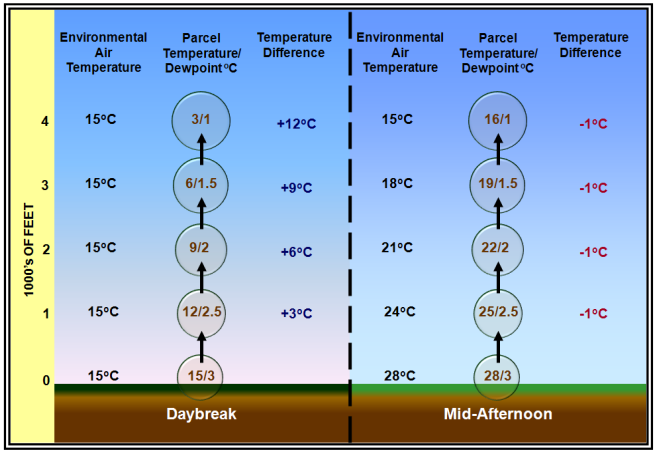
Figure. Diurnal Temperature Variation Effects on Stability
Measurements of Stability
Several stability indexes and other quantities exist that evaluate atmospheric stability and the potential for convective storms. The most common of these are Lifted Index (LI) and Convective Available Potential Energy (CAPE).
Lifted Index (LI)
The LI is the temperature difference between an air parcel (usually at the surface) lifted adiabaticallyand the temperature of the environment at a given pressure (usually 500 mb) in the atmosphere. A positive value indicates a stable column of air (at the respective pressure), a negative value indicates an unstable column of air, and a value of zero indicates a neutrally stable column of air. The larger the positive (negative) LI value, the more stable (unstable) the column of air.
LI is generally used in thunderstorm forecasting; however, CAPE is generally considered a superior measurement of instability. However, LI is easier to determine without using a computer.
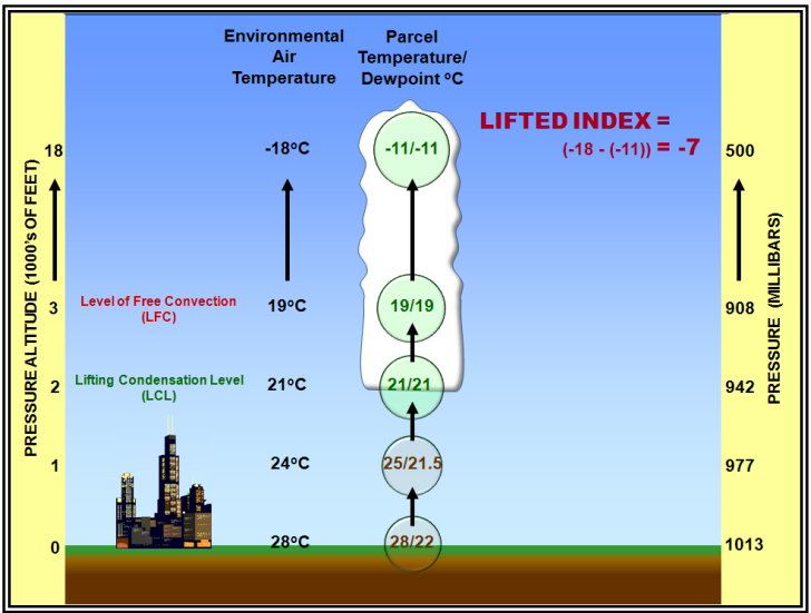
Figure. Lifted Index Example
Convective Available Potential Energy (CAPE)
CAPE is the maximum amount of energy available to an ascending air parcel for convection. CAPE is represented on a sounding by the area enclosed between the environmental temperature profile and the path of a rising air parcel over the layer within which the latter is warmer than the former. Units are joules per kilogram (J/kg) of air. Any value greater than 0 J/kg indicates instability and the possibility of thunderstorms.
CAPE is directly related to the maximum potential vertical speed within an updraft; thus, higher values indicate the potential for stronger updrafts. Observed values in thunderstorm environments often exceed 1,000 J/kg, and in extreme cases may exceed 5,000 J/kg.
Summary
Atmospheric stability influences weather by affecting the vertical motion of air. Stable air suppresses vertical motion while unstable air enhances it.


