Introduction
An air mass is a large body of air with generally uniform temperature and humidity. A wave cyclone is a low-pressure circulation that forms and moves along a front.
This chapter will discuss air masses, fronts, and the wave cyclone model.
Air Masses
The area from which an air mass originates is called a source region.
Air mass source regions range from extensive snow-covered polar areas to deserts to tropical oceans. The United States is not a favorable source region because of the relatively frequent passage of weather disturbances that disrupt any opportunity for an air mass to stagnate and take on the properties of the underlying region. The longer the air mass stays over its source region, the more likely it will acquire the properties of the surface below.
Air Mass Classification
Air masses are classified according to the temperature and moisture properties of their source regions.
Temperature Properties
- Arctic (A)—An extremely deep, cold air mass that develops mostly in winter over arctic surfaces of ice and snow.
- Polar (P)—A relatively shallow, cool to cold air mass that develops over high latitudes.
- Tropical (T)—A warm to hot air mass that develops over low latitudes.
Moisture Properties
- Continental (c)—A dry air mass that develops over land.
- Maritime (m)—A moist air mass that develops over water.
Five Air Masses
When this classification scheme is applied, the following five air masses may be identified:
- Continental Arctic (cA)—Cold, dry.
- Continental Polar (cP)—Cold, dry.
- Continental Tropical (cT)—Hot, dry.
- Maritime Polar (mP)—Cool, moist.
- Maritime Tropical (mT)—Warm, moist.
Note: Maritime Arctic (mA) is not listed, since it seldom (if ever) forms.
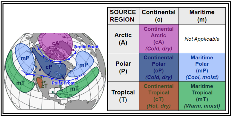
Figure. Air Mass Classification
Air Mass Modification
As these air masses move around the Earth, they can begin to acquire different attributes. For example, in winter, an arctic air mass (very cold and dry air) can move over the ocean, picking up some warmth and moisture from the warmer ocean and becoming a maritime polar (mP) air mass—one that is still fairly cold but contains moisture. If that same polar air mass moves south from Canada into the southern United States, it will pick up some of the warmth of the ground, but due to lack of moisture, it remains very dry. This is called a continental polar (cP) air mass.
The Gulf Coast states and the eastern third of the country commonly experience the tropical air mass in the summer. Continental tropical (cT) air is dry air pumped north, off of the Mexican Plateau. If it becomes stagnant over the Midwest, a drought may result. Maritime tropical (mT) air is air from the tropics that has moved north over cooler water.
A warm, moist air mass moving over a cold surface produces stable air associated with stratiform clouds, fog, and drizzle.
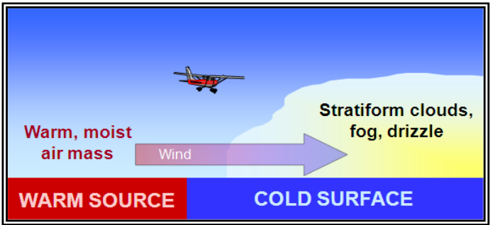
Figure. Air Mass Modification—Warm, Moist Air Mass Moving Over a Cold Surface
Lake Effect
Lake effect is the effect of any lake in modifying the weather near its shore and for some distance downwind. In the United States, the term is applied specifically to the region around the Great Lakes, and sometimes the Great Salt Lake in Utah. A lake effect can sometimes generate spectacular snowfall amounts to the lee side of the Great Lakes. This phenomenon is termed “lake effect snow.”
In autumn and winter, cumuliform clouds and showers often develop in bands over, and to the lee of, large, ice-free lakes. As initially cold, dry, stable polar air over land flows over the relatively warm water, the air is heated and moistened, and stability decreases. Shallow cumuliform clouds develop with low tops. The strength of the convection increases with increasing temperature differences between warm water and cold air, increasing wind speeds, and decreasing relative humidity within the cold, dry air.
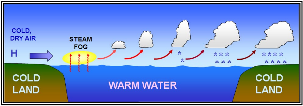
Figure. Lake Effect
Fronts
Air masses can control the weather for a relatively long time period ranging from days to months. Most weather occurs along the periphery of these air masses at boundaries called fronts. A front is a boundary or transition zone between two air masses. Fronts are classified by which type of air mass (cold or warm) is replacing the other.
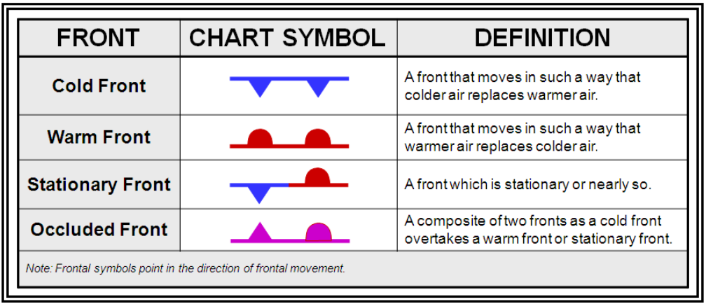
Figure. Fronts
Fronts are usually detectable at the surface in a number of ways: significant temperature gradients, or differences, exist along fronts (especially on the cold air side); winds usually converge, or come together, at fronts; and pressure typically decreases as a front approaches and increases after it passes.
Fronts do not exist only at the surface of the Earth; they have a vertical structure in which the front slopes over the colder (denser) air mass.
Warm Front
A warm front occurs when a warm mass of air advances and replaces a body of colder air. Warm fronts move slowly, typically 10 to 25 mph. The slope of the advancing front slides over the top of the cooler air and gradually pushes it out of the area. Warm fronts typically have a gentle slope, so the warm air rising along the frontal surface is gradual. This favors the development of widespread layered or stratiform cloudiness and precipitation along, and ahead of, the front if the warm rising air is stable.
Generally, prior to the passage of a warm front, cirriform or stratiform clouds, along with fog, can be expected to form along the frontal boundary. In the summer months, cumulonimbus clouds (thunderstorms) are likely to develop.
Light to moderate precipitation is probable, usually in the form of rain, sleet, snow, or drizzle, accentuated by poor visibility. The wind blows from the south-southeast, and the outside temperature is cool or cold with an increasing dewpoint. Finally, as the warm front approaches, the barometric pressure continues to fall until the front passes completely.
During the passage of a warm front, stratiform clouds are visible and drizzle may be falling. The visibility is generally poor, but improves with variable winds. The temperature rises steadily from the inflow of relatively warmer air. For the most part, the dewpoint remains steady and the pressure levels off. After the passage of a warm front, stratocumulus clouds predominate and rain showers are possible. The visibility eventually improves, but hazy conditions may exist for a short period after passage. The wind blows from the south-southwest. With warming temperatures, the dewpoint rises and then levels off. There is generally a slight rise in barometric pressure, followed by a decrease of barometric pressure.
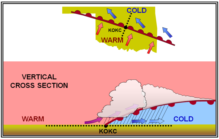
Figure. Warm Front
Cold Front
A cold front occurs when a mass of cold, dense, and stable air advances and replaces a body of warmer air. It is so dense, it stays close to the ground and acts like a snowplow, sliding under the warmer air and forcing the less dense air aloft. Cold fronts have a steep slope, and the warm air is forced upward abruptly. This often leads to a narrow band of showers and thunderstorms along, or just ahead of, the front if the warm rising air is unstable. Cold fronts move more rapidly than warm fronts, progressing at a rate of 25 to 30 mph. However, extreme cold fronts have been recorded moving at speeds of up to 60 mph.
The rapidly ascending air causes the temperature to decrease suddenly, forcing the creation of clouds. The type of clouds that form depends on the stability of the warmer air mass. A cold front in the Northern Hemisphere is normally oriented in a northeast to southwest manner and can be several hundred miles long, encompassing a large area of land.
Prior to the passage of a typical cold front, cirriform or towering cumulus clouds are present, and cumulonimbus clouds may develop. Rain showers may also develop due to the rapid development of clouds. A high dewpoint and falling barometric pressure are indicative of an imminent cold front passage.
As the cold front passes, towering cumulus or cumulonimbus clouds continue to dominate the sky. Depending on the intensity of the cold front, heavy rain showers form and may be accompanied by lightning, thunder, and/or hail. More severe cold fronts can also produce tornadoes. During cold front passage, the visibility is poor with winds variable and gusty, and the temperature and dewpoint drop rapidly. A quickly falling barometric pressure bottoms out during frontal passage, and then begins a gradual increase. After frontal passage, the towering cumulus and cumulonimbus clouds begin to dissipate to cumulus clouds with a corresponding decrease in the precipitation. Good visibility eventually prevails with the winds from the west-northwest. Temperatures remain cooler and the barometric pressure continues to rise.
Fast-moving cold fronts are pushed by intense pressure systems far behind the actual front. The friction between the ground and the cold front retards the movement of the front and creates a steeper frontal surface. This results in a very narrow band of weather, concentrated along the leading edge of the front. If the warm air being overtaken by the cold front is relatively stable, overcast skies and rain may occur for some distance behind the front. If the warm air is unstable, scattered thunderstorms and rain showers may form. A continuous line of thunderstorms, or squall line, may form along or ahead of the front. Squall lines present a serious hazard to pilots as squall-type thunderstorms are intense and move quickly. Behind a fast-moving cold front, the skies usually clear rapidly, and the front leaves behind gusty, turbulent winds and colder temperatures.
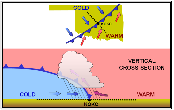
Figure. Cold Front
Stationary Front
When the forces of two air masses are relatively equal, the boundary or front that separates them remains stationary and influences the local weather for days. This front is called a stationary front. Stationary frontal slope can vary, but clouds and precipitation would still form in the warm rising air along the front . The weather associated with a stationary front is typically a mixture that can be found in both warm and cold fronts.
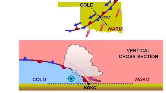
Figure. Stationary Front
Occluded Front
Cold fronts typically move faster than warm fronts, so in time they catch up to warm fronts. As the two fronts merge, an occluded front forms . At the occluded front, the cold air undercuts the retreating cooler air mass associated with the warm front, further lifting the already rising warm air. Clouds and precipitation can occur in the areas of frontal lift along, ahead of, and behind the surface position of an occluded front. As the occluded front approaches, warm front weather prevails, but is immediately followed by cold front weather.
There are two types of occluded fronts that can occur, and the temperatures of the colliding frontal systems play a large part in defining the type of front and the resulting weather.
A cold front occlusion occurs when a fast-moving cold front is colder than the air ahead of the slow-moving warm front. When this occurs, the cold air replaces the cool air and forces the warm front aloft into the atmosphere. Typically, the cold front occlusion creates a mixture of weather found in both warm and cold fronts, providing the air is relatively stable.
A warm front occlusion occurs when the air ahead of the warm front is colder than the air of the cold front. When this is the case, the cold front rides up and over the warm front. If the air forced aloft by the warm front occlusion is unstable, the weather is more severe than the weather found in a cold front occlusion. Embedded thunderstorms, rain, and fog are likely to occur.
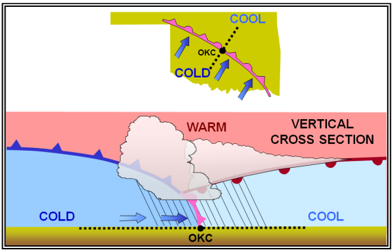
Figure. Occluded Front
The Wave Cyclone Model
A wave cyclone3 is a low-pressure circulation that forms and moves along a front. The circulation about the cyclone center tends to produce a wavelike kink along the front. Wave cyclones are the primary weather producers in the mid-latitudes. They are large lows that generally travel from west to east along a front. They last from a few days to more than a week.
A wave cyclone typically follows a predictable evolution. Initially, there is a stationary front separating warm air from cold air.
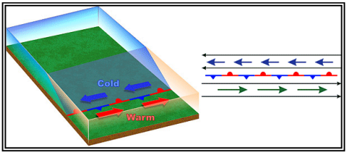
Figure. Wave Cyclone Model—Stage 1
A low-pressure wave forms on the front (see Figure 11-10). The front develops a kink where the wave develops. Precipitation develops with the heaviest intensity (dark green) located in the zone of lift along the front.
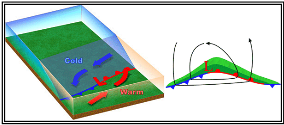
Figure. Wave Cyclone Model—Stage 2
As the wave intensifies, both the cold and warm fronts become better organized.
3 A wave cyclone should not be confused with the alternative name for a tornado. They are quite different.
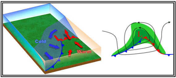
Figure. Wave Cyclone Model—Stage 3
In the fourth stage, the wave becomes a mature low. The occluded front forms as the cold front overtakes the warm front.
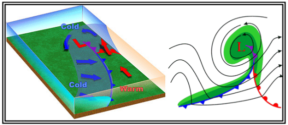
Figure. Wave Cyclone Model—Stage 4
As the cold front continues advancing on the warm front, the occlusion increases and eventually cuts off the supply of warm moist air . This causes the low to gradually dissipate.
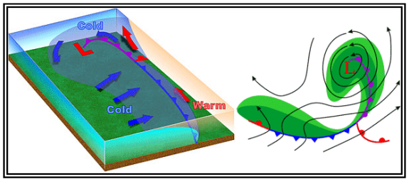
Figure. Wave Cyclone Model—Stage 5
Dryline
A dryline is a low-level boundary hundreds of miles long separating moist and dry air masses. In the United States, it typically lies north-south across the southern and central High Plains during the spring and early summer, where it separates moist (mT) air from the Gulf of Mexico to the east and dry desert (cT) air from the southwestern states to the west.
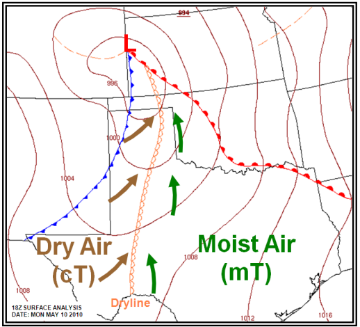
Figure. Dryline Example
The dryline typically advances eastward during the afternoon and retreats westward at night. However, a strong wave cyclone can sweep the dryline eastward into the Mississippi Valley, or even farther east, regardless of the time of day. Low-level clouds and early morning fog often prevail in the moist air, while generally clear skies mark the dry side. Severe and sometimes tornadic thunderstorms often develop along a dryline or in the moist air just to the east of it, especially when it begins moving eastward.
A typical dryline passage results in a sharp drop in humidity (hence the name), clearing skies, and a wind shift from south or southeasterly to west or southwesterly. Blowing dust and rising temperatures also may follow, especially if the dryline passes during the daytime. These changes occur in reverse order when the dryline retreats westward.


