Introduction
Global circulations explain how air and storm systems that could have potential impacts on aircraft operations travel over the Earth’s surface. Jet streams are relatively narrow bands of strong wind in the upper levels of the atmosphere. This chapter will discuss global circulations and jet streams.
Non-Rotating Earth Circulation System
The global circulation would be simple if the Earth did not rotate, the rotation was not tilted relative to the Sun, and had no water.
Without those factors, the ground and atmosphere directly beneath the Sun would be subject to more of the Sun’s heat than anywhere else on the planet. The result would be the Equator becoming very hot, with the hot air rising into the upper atmosphere.
That hot air would then move toward the poles, where it would become very cold and sink, returning to the Equator . One large area of high pressure would be at each of the poles, with a large belt of low pressure around the Equator.
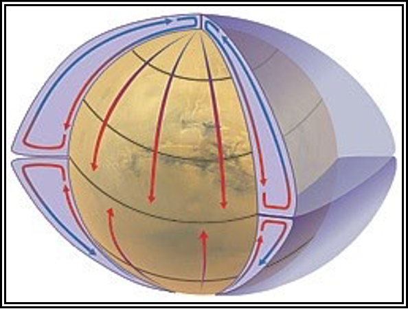
Figure . Non-Rotating, Non-Tilted, Waterless, Earth Circulation System
Rotating Earth Circulation System
However, since the Earth rotates, the axis is tilted, and there is more land mass in the Northern Hemisphere than in the Southern Hemisphere, the actual global pattern is much more complicated.
Instead of one large circulation between the poles and the Equator, there are three circulations.
- Hadley cell—Low-latitude air movement toward the Equator that, with heating, rises vertically with poleward movement in the upper atmosphere. This forms a convection cell that dominates tropical and subtropical climates.
- Ferrel cell—A mid-latitude mean atmospheric circulation cell for weather, named by William Ferrel in the 19th century. In this cell, the air flows poleward and eastward near the surface, and equatorward and westward at higher levels.
Polar cell—Air rises, diverges, and travels toward the poles. Once over the poles, the air sinks, forming the polar highs. At the surface, air diverges outward from the polar highs. Surface winds in the polar cell are easterly (polar easterlies).
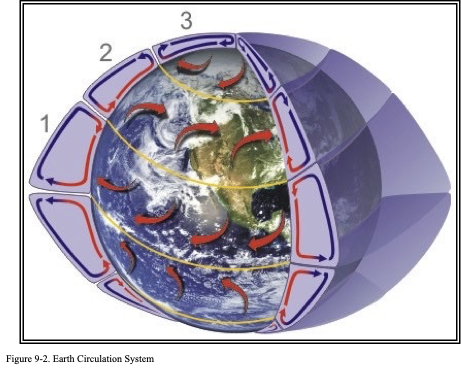
Between each of these circulation cells are bands of high and low pressure at the surface. The high-pressure band is located about 30° N/S latitude and at each pole. Low-pressure bands are found at the Equator and 50° to 60° N/S latitude.
Usually, fair and dry/hot weather is associated with high pressure, and rainy and stormy weather is associated with low pressure. The results of these circulations become evident on a globe. Consider the number of deserts located along the 30° N/S latitude around the world compared to the region between 50°–60° N/S latitude. The higher latitudes, especially near the west coast of continents, tend to have more precipitation due to more storms moving around the Earth at these latitudes.
Jet Streams
Jet streams are relatively narrow bands of strong wind in the upper levels of the atmosphere. The winds blow from west to east in jet streams, but the flow often meanders southward and northward in waves. Jet streams follow the boundaries between hot and cold air. Since these hot and cold air boundaries are most pronounced in winter, jet streams are the strongest for both the Northern and Southern Hemisphere winters.
Direction of Wind Flow
Why do the jet stream winds blow from west to east? As stated in the previous section, if the Earth was not rotating, the warm air would rise at the Equator and move toward both the poles. The Earth’s rotation divides this circulation into three cells. Likewise, the Earth’s rotation is responsible for the jet stream.
The motion of the air is not directly north and south, but rather is affected by the momentum the air has as it moves away from the Equator and how fast a location on or above the Earth moves relative to the Earth’s axis.
An object’s speed relative to the Earth’s axis depends on its location. Someone standing on the Equator is moving much faster than someone standing on a 45° latitude line. The person at the position on the Equator arrives at the yellow line sooner than the other two. Someone standing on a pole is not moving at all (except that person would be slowly spinning). The speed of the rotation is great enough to cause a person to weigh 1 pound (lb) less at the Equator than they would at the North or South Pole.
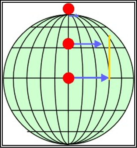
Figure . Speed Relative to the Earth’s Axis Versus Latitude
The momentum of air as it travels around the Earth is conserved, which means as the air that is over the Equator starts moving toward one of the poles, it keeps its eastward motion constant. The Earth below the air, however, moves slower, as that air travels toward the poles. The result is that the air moves faster and faster in an easterly direction (relative to the Earth’s surface below) the farther it moves from the Equator.
Location
In addition, with the three cell circulations mentioned previously, the regions around 30° N/S and 50°–60° N/S are areas where temperature changes are the greatest . As the difference in temperature between the two locations increases, the strength of the wind increases. Therefore, the regions around 30° N/S and 50°–60° N/S are also regions where the wind in the upper atmosphere is the strongest.
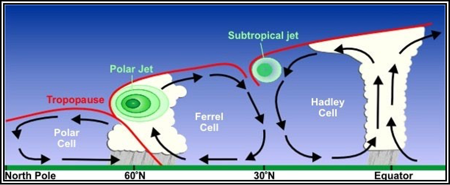
Figure . Three Cell Circulations and Jet Stream Location
The 50°–60° N/S region is where the polar jet is located with the subtropical jet located around 30° N (see Figure 9-5). Jet streams vary in height from around flight level (FL) 200 to FL450 and can reach speeds of more than 275 miles per hour (mph) (239 knots (kt)/442 kilometers per hour (km/h)).
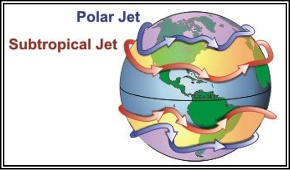
Figure . Illustration of Polar and Subtropical Jet Streams and Their Relative Locations Around the Globe
The actual appearance of jet streams results from the complex interaction between many variables, such as the location of high- and low-pressure systems, warm and cold air, and seasonal changes. They meander around the globe, dipping and rising in altitude/latitude, splitting at times and forming eddies, and even disappearing altogether to appear somewhere else. Jet streams also follow the Sun, in that as the Sun’s elevation increases each day in the spring, the jet streams shift north, moving into Canada by summer. As autumn approaches and the Sun’s elevation decreases, the jet stream moves south into the United States, helping to bring cooler air to the country.
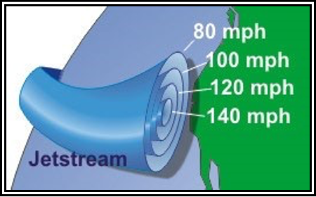
Figure . Jet Stream Wind Speeds
Also, the jet stream is often indicated by a line on maps, and shown by television meteorologists. The line generally points to the location of the strongest wind (see Figure 9-6). In reality, jet streams are typically much wider. They are less a distinct location, and more a region where winds increase toward a core of highest speed. One way of visualizing this is to consider a river. The river’s current is generally the strongest in the center, with decreasing strength as one approaches the river’s bank. It can be said that jet streams are rivers of air.


