In each level, the clouds may be divided by type (genera). The definitions of the cloud types (given below) do not cover all possible aspects, but are limited to a description of the main types and of the essential characteristics necessary to distinguish a given type from another type having a somewhat similar appearance.
Clouds are identified based upon one’s observation point at a particular elevation. From sea level, one might observe stratus clouds enveloping the top of a mountain. However, on the mountaintop, one would observe and report that same cloud as fog.
The exception to this is cumulus or cumulonimbus clouds over a mountain. Even though these low-level clouds typically have bases under 6,500 ft (2,000 m), if one were to observe them over a mountaintop, their base might be 12,000 ft (3,600 m) or higher relative to a particular location closer to sea level. However, due to their location over the mountain, one would still call them cumulus or cumulonimbus clouds, as appropriate.
High Clouds
Cirrus (Ci), cirrocumulus (Cc), and cirrostratus (Cs) are high-level clouds. They are typically thin and white in appearance, but can appear in a magnificent array of colors when the Sun is low on the horizon. They are composed almost entirely of ice crystals.
Cirrus (Ci)
Cirrus (Ci) (see Figure A-1) is a cloud type composed of detached cirriform elements in the form of white, delicate filaments of white (or mostly white) patches, or of narrow bands. These clouds have a fibrous (hairlike) appearance and/or a silky sheen. Many of the ice crystal particles of cirrus are sufficiently large to acquire an appreciable speed of fall; therefore, the cloud elements often trail downward in well-defined wisps called “mares’ tails.” Cirrus clouds in themselves have little effect on aircraft and contain no significant icing or turbulence.
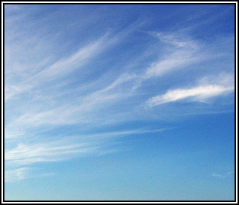
Figure A-1. Cirrus (Ci)
Cirrocumulus (Cc)
Cirrocumulus (Cc) is a cirriform cloud type appearing as a thin white patch, sheet, or layer of cloud without shading, and is composed of very small elements in the form of grains, ripples, etc. The elements may be merged or separate, and more or less regularly arranged; they subtend an angle of less than 1° when observed at an angle of more than 30° above the horizon.
Cirrocumulus (see Figure A-2) may be composed of highly supercooled water droplets, as well as small ice crystals, or a mixture of both; usually, the droplets are rapidly replaced by ice crystals. Pilots can expect some turbulence and icing.
Cirrocumulus is not very common. It is composed of very small elements, which never show shading. The cloud is frequently associated with cirrus or cirrostratus.
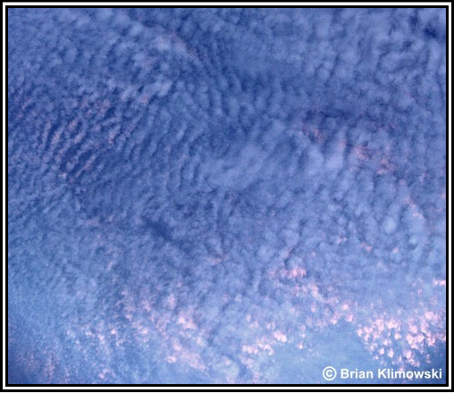
Figure A-2. Cirrocumulus (Cc)
Cirrostratus (Cs)
Cirrostratus (Cs) (see Figure A-3) is a cloud type appearing as a whitish veil, usually fibrous (hairlike) but sometimes smooth, that may totally cover the sky, and that often produces halo phenomena, either partial or complete. Cirrostratus occasionally may be so thin and transparent as to render it nearly indiscernible, especially through haze or at night. At such times, the existence of a halo around the Sun or Moon may be the only revealing feature.
The angle of incidence of illumination upon a cirrostratus layer is an important consideration in evaluating the identifying characteristics. When the Sun is high (generally above 50° elevation), cirrostratus never prevents the casting of shadows by terrestrial objects, and a halo might be completely circular. At progressively lower angles of the Sun, halos become fragmentary, and light intensity noticeably decreases. When near the horizon, cirrostratus may be impossible to distinguish from cirrus.
Cirrostratus clouds are composed primarily of ice crystals and contain little, if any, icing and no turbulence.
Figure A-3. Cirrostratus (Cs)
Middle Clouds
Altocumulus (Ac), altostratus (As), and nimbostratus (Ns) are mid-level clouds. They are composed primarily of water droplets; however, they can also be composed of supercooled liquid water droplets and/or ice crystals when temperatures are below freezing. Altostratus is usually found in the middle level, but it often extends higher. Nimbostratus is almost invariably found in the middle level, but it usually extends into the other levels.
Altocumulus (Ac)
Altocumulus (Ac) (see Figure A-4) is a cloud type, white and/or gray in color, that occurs as a layer or patch with a waved aspect, the elements of which appear as laminae, rounded masses, rolls, etc. These elements usually are sharply outlined, but they may become partly fibrous or diffuse; they may or may not be merged.
Small liquid water droplets invariably compose the major part of the composition of altocumulus. This results in a sharp outline and small internal visibility. At very low temperatures, however, ice crystals may form. Pilots flying through altocumulus can expect some turbulence and small amounts of icing.
The altocumulus in Figure A-4 is a single level, the greater part of which is sufficiently transparent to reveal the position of the Sun and Moon. The clouds do not progressively invade the sky, and the individual elements change very little. These thin altocumulus clouds usually produce a corona.
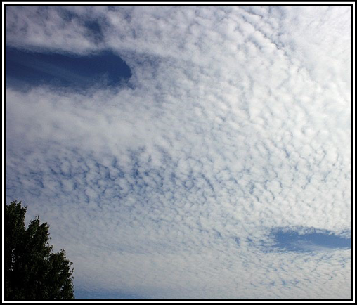
Figure A-4. Altocumulus (Ac)
Altocumulus Lenticularis
Altocumulus Lenticularis, commonly known as “Altocumulus Standing Lenticular (ACSL)” (see Figure A-5), are an orographic type of cloud. They often appear to be dissolving in some places and forming in others. They also often form in patches in the shape of almonds or wave clouds. These formations are caused by wave motions in the atmosphere and are frequently seen in mountainous or hilly areas. They may be triggered off by hills only a few thousand feet high and may extend downwind for more than 60 mi (100 km). The cloud elements form at the windward edge of the cloud and are carried to the downwind edge where they evaporate. The cloud as a whole is usually stationary or slow moving. These clouds often have very smooth outlines and show definite shading.
ACSL clouds indicate the position of the wave crests, but they do not necessarily give an indication on the intensity of turbulence or strength of updrafts and downdrafts. This is because the clouds depend on both lifting and moisture. A well-defined wave may be visible (i.e., ACSL cloud) in weak updrafts where there is an adequate supply of moisture, but may not be visible when the environment is very dry, even if the wave is intense.
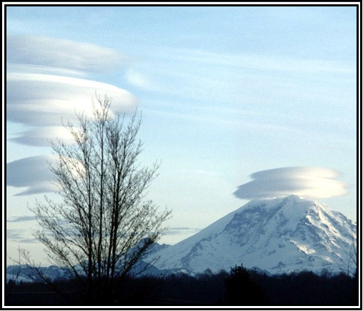
Figure A-5. Altocumulus Standing Lenticular (ACSL)
Altostratus (As)
Altostratus (As) (see Figure A-6) is a cloud type in the form of a gray or bluish (never white) sheet or layer of striated, fibrous, or uniform appearance. Altostratus very often totally covers the sky and may, in fact, cover an area of several thousand square miles. The layer has parts thin enough to reveal the position of the Sun, and if gaps and rifts appear, they are irregularly shaped and spaced.
Within the rather large vertical extent of altostratus (from several hundred to thousands of feet), a very heterogeneous particulate composition may exist. In this most complete case, there may be distinguished:
- An upper part, mostly or entirely ice crystals;
- A middle part, a mixture of ice crystals and/or snowflakes and supercooled water droplets; and
- A lower part, mostly or entirely supercooled or ordinary water droplets.
Note: A number of partial combinations of these composition types may occur, but never an entire cloud like item 3 above.
The particles are widely dispersed enough so as not to obscure the Sun except by its thickest parts, but rather to impose a ground-glass effect upon the Sun’s image, and to prevent sharply outlined shadows from being cast by terrestrial objects. Halo phenomena do not occur. Pilots can expect little or no turbulence, but light to moderate icing in the supercooled water regions.
Thin altostratus usually evolves from the gradual thickening of a veil of cirrostratus. This means that unlike most clouds, which increase in height as they grow, altostratus (and nimbostratus) grow as the base of the cloud lowers. Altostratus is grayish or bluish color, never white, and the greater part is always translucent enough to reveal the Sun (or Moon) as through ground glass. Objects on the ground do not cast shadows and halo phenomena are never seen.
Nimbostratus (Ns)
Nimbostratus (Ns) (see Figure A-7) is a gray cloud layer, often dark, rendered diffuse by more or less continuously falling rain, snow, ice pellets, etc., which in most cases reaches the ground. It is not accompanied by lightning, thunder, or hail.
Nimbostratus is composed of suspended water droplets, sometimes supercooled, and of falling raindrops and/or snow crystals or snowflakes. It occupies a layer of large horizontal and vertical extent. The great density and thickness (usually many thousands of feet) of this cloud prevent observation of the Sun. This, plus the absence of small droplets in its lower portion, gives nimbostratus the appearance of dim and uniform lighting from within. It also follows that nimbostratus has no well-defined base, but rather a deep zone of visibility attenuation. Frequently, a false base may appear at the level where snow melts into rain. It is officially classified as a middle cloud, although it may merge into very low stratus or stratocumulus. Other cloud classification systems may identify it as a low-level cloud. Nimbostratus produces very little turbulence but can pose a serious icing problem if temperatures are near or below freezing.
Thick altostratus is denser and of a darker gray or bluish gray than thin altostratus with the greater part sufficiently dense to completely mask the Sun or Moon. With further thickening of the altostratus and a lowering of its base, the cloud may begin to produce precipitation, at which point it is called nimbostratus. Some cloud charts will depict nimbostratus as a low-level cloud. This is because oftentimes, during continuously falling precipitation, the base of nimbostratus clouds decrease into the low level. But officially and historically, nimbostratus is classified as a mid-level cloud.
Figure A-7. Thick Altostratus (As) or Nimbostratus (Ns)
Low Clouds
Cumulus (Cu), towering cumulus (TCu), stratocumulus (Sc), stratus (St), and cumulonimbus (Cb) are low clouds composed of water droplets. However, they can also be composed of supercooled liquid water droplets and/or ice crystals when temperatures are below freezing. Cumulus and cumulonimbus usually have bases in the low level, but their vertical extent is often so great that their tops may reach into the middle and high levels.
Cumulus (Cu) and Towering Cumulus (TCu)
Cumulus is a cloud type in the form of individual, detached elements that are generally dense and possess sharp, nonfibrous outlines. These elements develop vertically, appearing as rising mounds, domes, or towers, the upper parts of which often resemble a cauliflower. The sunlit parts of these clouds are mostly brilliant white; their bases are relatively dark and nearly horizontal. Near the horizon, the vertical development of cumulus often causes the individual clouds to appear merged. If precipitation occurs, it is usually of a showery nature. Various effects of wind, illumination, etc., may modify many of the aforementioned characteristics.
Cumulus is composed of a great density of small water droplets, frequently supercooled. Within the cloud, larger water drops are formed that may, as the cloud develops, fall from the base as rain or virga.[1] Ice crystal formation will occur within the cloud at sufficiently low temperatures, particularly in upper portions as the cloud grows vertically.
For cumulus with little vertical development (see Figure A-8), pilots can expect some turbulence and no significant icing. However, for towering cumulus (i.e., cumulus of moderate/strong development), pilots can expect very strong turbulence and some clear icing above the freezing level (where temperatures are negative). Towering cumulus (see Figure A-9) is also referred to as the first stage of a thunderstorm.
Virga are wisps or streaks of water or ice particles falling out of a cloud, but vaporizing before reaching the Earth’s surface as precipitation.
Figure A-8. Cumulus (Cu) with Little Vertical Development
Cumulus formation is often preceded by hazy spots out of which the clouds evolve. When completely formed, the clouds have clear-cut horizontal bases and flattened or slightly rounded tops. At this stage of development, they are known as fair weather cumulus. Over land, on clear mornings, cumulus may form as the Sun rapidly heats the ground. Near coasts, cumulus may form over the land by day in a sea breeze and over the sea during the night in a land breeze.
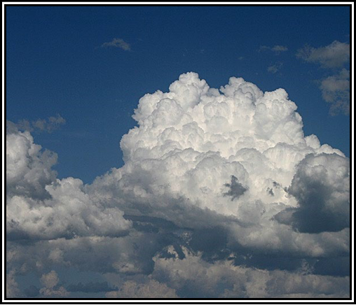
Figure A-9. Towering Cumulus (TCu)
Stratocumulus (Sc)
Stratocumulus (Sc) (see Figure A-10) is a cloud type, predominantly stratiform, in the form of a gray and/or whitish layer or patch, which nearly always has dark parts and is nonfibrous (except for virga). Its elements are tessellated, rounded, roll-shaped, etc.; they may or may not be merged, and usually are arranged in orderly groups, lines, or undulations, giving the appearance of a simple (or occasionally a cross-pattern) wave system. These elements are generally flat-topped, smooth, and large; observed at an angle of more than 30° above the horizon, the individual stratocumulus element subtends an angle of greater than 5°. When a layer is continuous, the elemental structure is revealed in true relief on its undersurface.
Stratocumulus is composed of small water droplets, sometimes accompanied by larger droplets, soft hail, and (rarely) snowflakes. Under ordinary conditions, ice crystals are too sparse even to give the cloud a fibrous aspect; however, in extremely cold weather, ice crystals may be numerous enough to produce abundant virga and sometimes even halo phenomena. The highest liquid water contents are in the tops of these clouds where the icing threat is the greatest, if cold enough. Virga may form under the cloud, particularly at very low temperatures. Precipitation rarely occurs with stratocumulus.
Pilots can expect some turbulence and possible icing at subfreezing temperatures. Ceiling and visibility are usually better than with low stratus.
Figure A-10. Stratocumulus (Sc)
The stratocumulus in Figure A-10 occurs in patches or layers, composed of rounded masses or rolls, at one or more levels. The clouds are gray or whitish and always have dark parts. Sometimes the elements lie in parallel bands. Due to perspective, these may appear to converge towards the horizon. It may also occur in the shape of lenses or almonds, although this is fairly rare.
Stratus (St)
Stratus (St) (see Figure A-11 and Figure A-12) is a cloud type in the form of a gray layer with a fairly uniform base. Stratus does not usually produce precipitation, but when it does occur, it is in the form of minute particles, such as drizzle, ice crystals, or snow grains. Stratus often occurs in the form of ragged patches or cloud fragments, in which case rapid transformation is a common characteristic. When the Sun is seen through the cloud, its outline is clearly discernible. In the immediate area of the solar disk, stratus may appear very white. Away from the Sun, and at times when the cloud is sufficiently thick to obscure it, stratus gives off a weak, uniform luminance.
The particulate composition of stratus is quite uniform, usually of fairly widely dispersed water droplets and, at lower temperatures, of ice crystals (although this is much less common). Halo phenomena may occur with this latter composition.
Stratus produces little or no turbulence, but temperatures near or below freezing can create hazardous icing conditions. When stratus is associated with fog or precipitation, the combination can become troublesome for visual flying. Stratus most commonly occurs as a gray, fairly uniform, and featureless single layer of low cloud. Occasionally, it can be dark or threatening, although at most it can only produce weak precipitation. This feature makes it fairly easy to distinguish it from nimbostratus (Ns), which nearly always produces rain, snow, or ice pellets. Fog will often lift into a layer of stratus by an increase in wind or a rise in temperature. Stratus is sometimes comparatively thin, and the disk of the Sun or Moon may be seen with a clear outline
Figure A-11. Stratus (St) Stratus fractus (StFra) and/or cumulus fractus (CuFra) (see Figure A-12) are ragged shreds of low clouds that always appear in association with other clouds for a short time before, during, and a short time after precipitation. They often form beneath lowering altostratus (As) or nimbostratus (Ns). They also occur beneath cumulonimbus (Cb) and precipitating cumulus (Cu) and are collectively known as “scud clouds.”
Figure A-12. Stratus Fractus (StFra) and/or Cumulus Fractus (CuFra) of Bad Weather
Cumulonimbus (Cb)
Cumulonimbus (Cb) (see Figure A-13 and Figure A-14) is a cloud type, exceptionally dense and vertically developed, occurring either as isolated clouds or as a line or wall of clouds with separated upper portions. These clouds appear as mountains or huge towers, at least a part of the upper portions of which are usually smooth, fibrous, or striated, and almost flattened as it approaches the tropopause. This part often spreads out in the form of an anvil or vast plume. Under the base of cumulonimbus, which is often very dark, there frequently exist virga, precipitation, and low, ragged clouds, either merged with it or not. Its precipitation is often heavy and always of a showery nature. The usual occurrence of lightning and thunder within or from this cloud leads to its popular appellations: thundercloud, thunderhead (the latter usually refers only to the upper portion of the cloud), and thunderstorm.
Cumulonimbus is composed of water droplets and ice crystals, the latter almost entirely in its upper portions. It also contains large water drops, snowflakes, snow pellets, and sometimes hail. The liquid water forms may be substantially supercooled. Cumulonimbus contains nearly the entire spectrum of flying hazards, including extreme turbulence.
In Figure A-13, no part of the cloud top has acquired a fibrous appearance or any anvil development. The protuberances tend to form a whitish mass without striations. Showers or thunderstorms may occur. The presence of lightning/thunder differentiate between this cloud and towering cumulus. Cumulus, stratocumulus, or stratus may also be present.
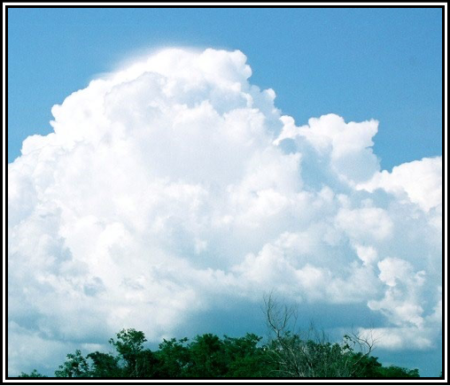
Figure A-13. Cumulonimbus (Cb) Without Anvil In Figure A-14, the characteristic shape of these clouds can only be seen as a whole when viewed from a distance. The tops of these massive clouds show a fibrous or striated structure that frequently resembles an anvil, plume, or huge mass of hair. They may occur as an isolated cloud or an extensive wall and squalls, hail, and/or thunder often accompany them. Underneath the base, which is often very dark, stratus fractus frequently form and, in storms, these may be only a few hundred feet above the Earth’s surface, and they can merge to form a continuous layer. Mammatus may form, especially on the underside of the projecting anvil, and may appear particularly prominent when the Sun is low in the sky. A whole variety of other clouds, such as dense cirrus, altocumulus, altostratus, stratocumulus, cumulus, and stratus may also be present.
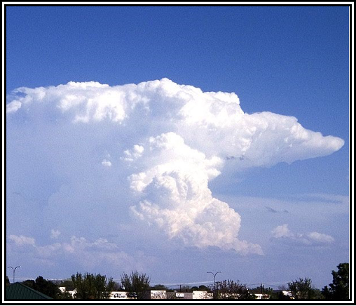
Figure A-14. Cumulonimbus (Cb) with Anvil


