Introduction
In general, icing is any deposit of ice forming on an object. It is one of the major weather hazards to aviation. Icing is a cumulative hazard. The longer an aircraft collects icing, the worse the hazard becomes.
Supercooled Water
Freezing is a complex process. Pure water suspended in the air does not freeze until it reaches a temperature of -40 °C. This occurs because surface tension of the droplets inhibits freezing. The smaller and purer the water droplet, the more likely it is supercooled. Also, supercooled water can exist as large drops known as Supercooled Large Drops (SLD). SLDs are common in freezing rain and freezing drizzle situations.
Supercooled water content of clouds varies with temperature. Between 0 and -10 °C, clouds consist mainly of supercooled water droplets. Between -10 and -20 °C, liquid droplets coexist with ice crystals. Below -20 °C, clouds are generally composed entirely of ice crystals. However, strong vertical currents (e.g., cumulonimbus) may carry supercooled water to great heights where temperatures are as low as -40 °C.
Supercooled water will readily freeze if sufficiently agitated. This explains why airplanes collect ice when they pass through a liquid cloud or precipitation composed of supercooled droplets.
Structural Icing
Structural icing is the ice that sticks to the outside of the airplane. It occurs when supercooled water droplets strike the airframe and freeze. Structural icing can be categorized into three types: rime, clear (or glaze), and mixed.
Icing intensities are described in the AIM, Chapter 7, Section 1, Meteorology.
Rime Icing
Rime ice is rough, milky, and opaque ice formed by the instantaneous freezing of small, supercooled water droplets after they strike the aircraft. It is the most frequently reported icing type. Rime ice can pose a hazard because its jagged texture can disrupt an aircraft’s aerodynamic integrity.
Rime icing formation favors colder temperatures, lower liquid water content, and small droplets. It grows when droplets rapidly freeze upon striking an aircraft. The rapid freezing traps air and forms a porous, brittle, opaque, and milky-colored ice. Rime ice grows into the air stream from the forward edges of wings and other exposed parts of the airframe.
Clear Icing
Clear ice (or glaze ice) is a glossy, clear, or translucent ice formed by the relatively slow freezing of large, supercooled water droplets. Clear icing conditions exist more often in an environment with warmer temperatures, higher liquid water contents, and larger droplets.
Clear ice forms when only a small portion of the drop freezes immediately while the remaining unfrozen portion flows or smears over the aircraft surface and gradually freezes. Few air bubbles are trapped during this gradual process. Thus, clear ice is less opaque and denser than rime ice. It can appear either as a thin smooth surface or as rivulets, streaks, or bumps on the aircraft.
Clear icing is a more hazardous ice type for many reasons. It tends to form horns near the top and bottom of the airfoils’ leading edge, which greatly affects airflow. This results in an area of disrupted and turbulent airflow that is considerably larger than that caused by rime ice. Since it is clear and difficult to see, the pilot may not be able to quickly recognize that it is occurring. It can be difficult to remove since it can spread beyond the deicing or anti-icing equipment, although in most cases, it is removed nearly completely by deicing devices.
Supercooled Large Drops (SLD)
A type of clear icing that is especially dangerous to flight operations is ice formed from SLDs. These are water droplets in a subfreezing environment with diameters larger than 40 microns, such as freezing drizzle (40 to 200 microns) and freezing rain (>200 microns). These larger droplets can flow along the airfoil for some distance prior to freezing. SLDs tend to form a very lumpy, uneven, and textured ice similar to glass in a bathroom window.
SLD ice tends to form aft, beyond the reach of deicing equipment. Thus, ice remaining on the airfoil continues to disrupt the airflow and reduce the aircraft’s aerodynamic integrity. Even a small amount of ice on the lower and upper surfaces of the airfoil can seriously disrupt its aerodynamic properties. The residual ice generates turbulence along a significant portion of the airfoil. This residual ice can act as a spoiler, a device actually used to slow an aircraft in flight. In extreme cases, turbulence and flow separation bubbles can travel along the airfoil and inadvertently activate the ailerons, creating dangerously unstable flying conditions.
Mixed Icing
Mixed ice is a mixture of clear ice and rime ice. It forms as an airplane collects both rime and clear ice due to small-scale (tens of kilometers or less) variations in liquid water content, temperature, and droplet sizes. Mixed ice appears as layers of relatively clear and opaque ice when examined from the side.
Mixed icing poses a similar hazard to an aircraft as clear ice. It may form horns or other shapes that disrupt airflow and cause handling and performance problems. It can spread over more of the airframe’s surface and is more difficult to remove than rime ice. It can also spread over a portion of airfoil not protected by anti-icing or deicing equipment. Ice forming farther aft causes flow separation and turbulence over a large area of the airfoil, which decreases the ability of the airfoil to keep the aircraft in flight.
Icing Factors
Structural icing is determined by many factors. The meteorological quantities most closely related to icing type and severity are, in order of importance: SLWC, temperature (altitude), and droplet size. However, aircraft type/design and airspeed are also important factors.
SLWC is important in determining how much water is available for icing. The highest quantities can be found in cumuliform clouds, with the lowest quantities found in stratiform clouds. However, in most icing cases, SLWC is low.
Icing potential is very temperature dependent. For icing to occur, the OAT must be below 0 °C. As clouds get colder, SLWC decreases until only ice crystals remain. Thus, almost all icing tends to occur in the temperature interval between 0 °C and -20 °C, with about half of all reports occurring between -8 °C and -12 °C. In altitude terms, the peak of occurrence is near 10,000 ft, with approximately half of incidents occurring between 5,000 and 13,000 ft. The only physical cold limit to icing is at -40 °C because liquid droplets freeze without nuclei present.
In general, rime icing tends to occur at temperatures colder than -15 °C, clear ice when the temperature is warmer than -10 °C, and mixed ice at temperatures in between. This is only general guidance. The type of icing will vary depending on the liquid water content, droplet size, and aircraft-specific variables.
An airframe can remain cold (temperature below 0 °C) in a warm (temperature above 0 °C) atmosphere if it is cold-soaked. For example, if an aircraft has been flying in a cold environment, but then descends into warmer temperatures, the airframe does not heat up immediately to the air temperature. For some aircraft, the airframe can remain colder than 0 °C for some time, even after landing. Aircraft with fuel tanks mounted flush to the airframe are particularly susceptible to icing, even in an environment where the air temperature is slightly above 0 °C. Because these characteristics vary from airframe to airframe, it is important for pilots to be aware of the limitations of their aircraft.
Droplet size can influence icing, but is not as important as SLWC and temperature, unless the droplets are larger than cloud droplets in size (e.g., freezing drizzle and freezing rain). Droplet size affects the collection of drops by the airframe. Small droplets tend to impact the airfoil near the plane’s leading edge. Larger drops, including freezing rain and freezing drizzle, can cross the streamlines and impact farther back.
Aircraft airspeed is an important nonmeteorological factor that determines icing type and severity. The rate of supercooled water droplet impact increases with airspeed, which acts to increase ice accumulation, but this is counteracted by the increase of airframe skin surface heating due to friction. Typically, airframe icing is negligible at speeds above 575 kt.
Aircraft type and design are also important factors. Because these characteristics vary, it is important for pilots to be aware of the limitations of their aircraft.
Commercial jet aircraft are generally less vulnerable to structural icing than light turboprop aircraft. This is due to their rapid airspeed, powerful deicing equipment, and tendency to cruise at higher altitudes where temperatures are typically too cold for icing. Conversely, light turboprop aircraft are more susceptible to icing because they typically fly at lower altitudes where icing is more common and at slower speeds.
Icing in Stratiform Clouds
Icing in middle and low-level stratiform clouds is confined, on the average, to a layer between 3,000 and 4,000 ft thick. Thus, a change in altitude of only a few thousand feet may take the aircraft out of icing conditions, even if it remains in clouds. Icing intensity generally ranges from a trace to light, with the maximum values occurring in the cloud’s upper portions. Both rime and mixed icing are found in stratiform clouds. The main hazard lies in the great horizontal extent of stratiform clouds layers. High-level stratiform clouds (i.e., at temperatures colder than -20 °C) are composed mostly of ice crystals and produce little icing.
Icing in Cumuliform Clouds
The icing layer in cumuliform clouds is smaller horizontally, but greater vertically than in stratiform clouds. Icing is more variable in cumuliform clouds because many of the factors conducive to icing depend on the particular cloud’s stage of development. Icing intensities may range from a trace in small cumulus to severe in a large towering cumulus or cumulonimbus. Although icing occurs at all levels above the freezing level in a building cumuliform cloud, it is most intense in the upper portion of the cloud where the updraft is concentrated and SLDs are plentiful. Icing can extend to great heights in towering cumulus and cumulonimbus where strong updrafts allow SLDs to exist at temperatures as cold as -40 °C. Icing in a cumuliform cloud is usually clear or mixed with rime in the upper levels.
Icing with Fronts
Most icing reports occur in the vicinity of fronts. This icing can occur both above and below the front (see Figure 20-1).
For significant icing to occur above the front, the warm air must be lifted and cooled to saturation at temperatures below zero, making it contain supercooled water droplets. The supercooled water droplets freeze on impact with an aircraft. If the warm air is unstable, icing may be sporadic; if it is stable, icing may be continuous over an extended area. A line of showers or thunderstorms along a cold front may produce icing, but only in a comparatively narrow band along the front.
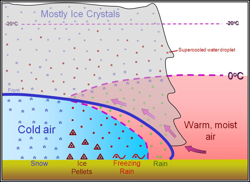
Figure . Icing with Fronts
A favored location for severe clear icing is freezing rain and/or freezing drizzle below a front. Rain forms above the frontal surface at temperatures warmer than freezing. Subsequently, it falls through air at temperatures below freezing and becomes supercooled. The SLDs freeze on impact with an aircraft. If the below-freezing layer is shallow, freezing rain will occur at the surface. If the below-freezing layer is deep, the supercooled droplets may freeze into ice pellets. Ice pellets indicate icing above. The icing can be severe because of the large amount of supercooled water. Icing in freezing precipitation is especially dangerous because it often extends horizontally over a broad area and a pilot may be unable to escape it by descending to a lower altitude.
Icing with Mountains
Icing is more likely and more severe in mountainous regions. Mountain ranges cause upward air motions on their windward side. These vertical currents support large supercooled water droplets above the freezing level. The movement of a front across a mountain range combines frontal lift with the mountain’s upslope flow effect to create extremely hazardous icing zones.
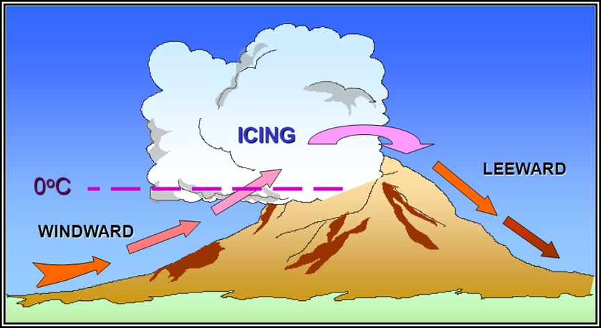
Figure 20-2. Icing with Mountains
The most severe icing occurs above the crests and on the ridges’ windward side. This zone usually extends to about 5,000 ft above the mountaintops, but can extend much higher if cumuliform clouds develop.
Icing with mountains can be especially hazardous because a pilot may be unable to descend to above-freezing temperatures due to terrain elevation. If a pilot approaches a mountain ridge from the windward side, the pilot’s aircraft may be unable to climb above the mountaintops, or even maintain altitude due to severe ice accumulation. The end result may be a crash.
Convective Icing
Thunderstorms produce abundant supercooled liquid water above the freezing level. When temperature in the upward current cools to about -15 °C, much of the remaining water vapor deposits as ice crystals; above this level, the amount of supercooled water decreases. However, supercooled water can exist at temperatures as cold as -40 °C in the presence of vigorous upward vertical motion, such as in a thunderstorm updraft.
Supercooled water freezes on impact with an aircraft. Clear icing can occur at any altitude above the freezing level, but at high levels, icing may be rime or mixed rime and clear. The abundance of supercooled water makes clear icing very rapid between 0 °C and -15 °C, and encounters can be frequent in a cluster of cells. Thunderstorm icing can be extremely hazardous.
Icing Hazards
Structural icing degrades an aircraft’s performance. It destroys the smooth flow of air, increasing drag while decreasing the ability of the airfoil to create lift. The actual weight of ice on an airplane is insignificant when compared to the airflow disruption it causes. As power is added to compensate for the additional drag and the nose is lifted to maintain altitude, the angle of attack is increased. This allows the underside of the wings and fuselage to accumulate additional ice.
Wind tunnel and flight tests have shown that frost, snow, and ice accumulations (on the leading edge or upper surface of the wing) no thicker or rougher than a piece of coarse sandpaper can reduce lift by 30 percent and increase drag up to 40 percent. Larger accretions can reduce lift even more and can increase drag by 80 percent or more.
Ice accumulates on every exposed frontal surface of the airplane: wings, propeller, windshield, antennas, vents, intakes, and cowlings. It can build in flight where no heat or boots can reach it. It can cause antennas to vibrate so severely that they break. In moderate-to-severe icing, a light aircraft could be subject to enough ice accumulation or accretion that continued flight is impossible. The airplane may stall at much higher speeds and lower angles of attack than normal. It can roll or pitch uncontrollably, and recovery might be impossible.
Regardless of anti-ice or deice protection offered by the aircraft, a pilot’s first course of action should be to leave the area of visible moisture. This might mean descending to an altitude below the cloud bases, climbing to an altitude that is above the cloud tops, or turning to a different course. If this is not possible, then the pilot should move to an altitude where the temperature is above freezing.
Engine Icing
Carburetor Icing
In an aspirated engine, the carburetion process can lower the temperature of the incoming air by as much as 38 °C (100 °F). If the moisture content is high enough, ice will form on the throttle plate and venturi, shutting off the supply of air to the engine. Even a small amount of carburetor ice will cause power loss and may make the engine run rough. It is possible for carburetor ice to form even when the skies are clear and the outside temperature is as high as 38 °C (100 °F) if the relative humidity is 50 percent or more. The icing risk does not go away until the humidity falls below roughly 25 percent and/or the OAT drops well below freezing.
High Ice Water Content (HIWC)
High Ice Water Content (HIWC) is a relatively new icing hazard, at least from the standpoint of research and understanding. HIWC refers to high-altitude ice crystals, which may exist in the tops and anvils of cumulonimbus clouds and thunderstorms. Under certain HIWC conditions, turbine engine performance can be affected, including flameouts. Research into HIWC conditions continues as of the writing of this section.


