Introduction
This chapter focuses on mountain waves and adverse winds. Other mountain weather phenomena are discussed in other chapters, which are noted.
Mountain Waves and Adverse Winds
The atmosphere is a fluid in motion. Just as the swiftly flowing water in a stream develops waves and eddies as it passes over and around obstructions, so does the atmosphere contain disturbances that develop as it interacts with mountainous terrain. These atmospheric eddies can range in size from a few centimeters to tens or hundreds of kilometers, and can present the pilot with relatively smooth air, or with turbulence of potentially destructive intensity, and the likelihood of loss of control.
When the atmosphere encounters a mountainous barrier, a number of responses are possible. If the wind is weak or the moving air mass exceptionally dense, the mountains may act as a dam, preventing the motion of air over the barrier. More frequently, strong winds flow over or around mountains or ridges. If the surrounding atmosphere is unstable, the vertical displacement of the air will (if sufficient moisture is present) lead to thunderstorm formation or at least the development of deep convective clouds. However, if the wind is sufficiently strong and the surrounding atmosphere is stable, a wave will develop.
The wave that results from vertical displacement of a stable air mass over a mountain or ridge can generally take one of two forms: vertically propagating mountain waves or trapped lee waves. Both types of waves can be hazardous to aviation operations. The particular type of wave or combination of waves that forms depends on the nature of the mountain range and on atmospheric properties upwind of the mountain. It is possible for both types of waves to exist at the same time. It also is possible to have hybrid or intermediate forms (i.e., waves that are only partially trapped).
The most severe mountain wind events usually occur when the large-scale (or synoptic) winds are strongest, from late autumn to early spring. During the remainder of the year, when the synoptic winds are normally much weaker, hazardous winds in the vicinity of mountains are more likely to be associated with thunderstorms and their outflow fields.
The mountain-induced flow fields to be discussed in this section are frequently accompanied by visual indicators (such as lenticular and rotor clouds or blowing dust). However, this is not always the case, and extremely severe wind events can occur with little or no visual warning of their presence.
Gravity Waves
In order for gravity waves to develop, the atmosphere must possess at least some degree of static stability. As stable air is deflected vertically by an obstacle (e.g., when an air mass moves over a mountain ridge), it resists the displacement because as it rises, it is heavier than the air surrounding it, and gravity is acting to return it to its equilibrium level. Because of its negative buoyancy, the deflected air begins to return to its original level once it has cleared the ridge. However, its momentum will cause it to overshoot the original altitude, warming by compression and now becoming less dense than the surrounding air. As a result, it begins to rise back to the equilibrium altitude, overshoots once more, and continues through a period of oscillations before the resulting wave motion dampens out. This process is depicted in Figure.
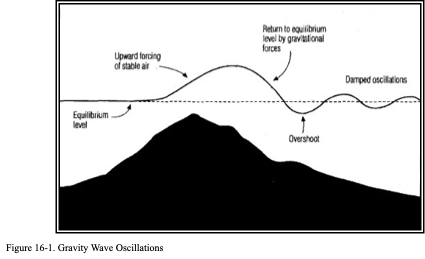
The described gravity wave will have measurable wavelength, amplitude, phase speed, and period. The period of this type of atmospheric disturbance is related to the temperature of the air and the “spread” between the existing lapse rate and the dry adiabatic lapse rate (or, equivalently, the degree of stability present). In general, the large-scale wind (wind shear) change in altitude and temperature (lapse rate), the size and shape of the mountain or ridge over which the air is moving, and the orientation of the wind relative to the ridge line all work together in determining the character of the disturbance that develops.
Kelvin-Helmholtz (K-H) Waves
When wind shear is very strong, another type of wave is possible. These waves, called gravity-shear or K-H waves, can occur when the kinetic energy inherent in the shear can overcome the damping effects of a stable temperature lapse rate. This effect is illustrated in Figure .
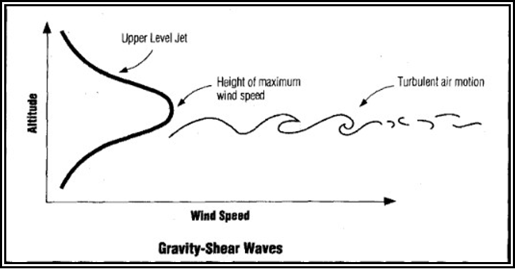
Figure . Gravity-Shear Waves
If the wind shear that penetrates the layer of the atmosphere is weak (some wind shear is nearly always present), a shear-induced wave motion will not occur. However, if the magnitude of the wind shear exceeds a critical value, wave motions will begin spontaneously within the shear layer, resulting in a K-H wave. The amplitude of the resulting wave will grow with the kinetic energy in the surrounding wind field until, like an ocean wave breaking on the shore, the wave overturns and breaks down into turbulence. The resulting turbulence can have a range of effects on aircraft. The clouds associated with shear-induced gravity waves can frequently be observed in the atmosphere, as shown in Figure.
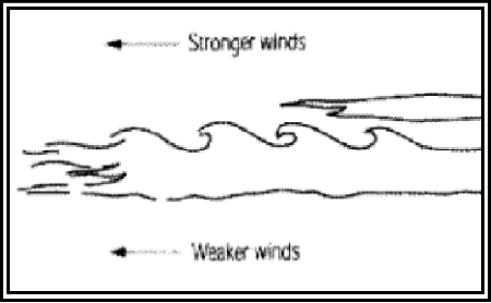
Figure . Schematic of Clouds Associated with Gravity-Shear Waves
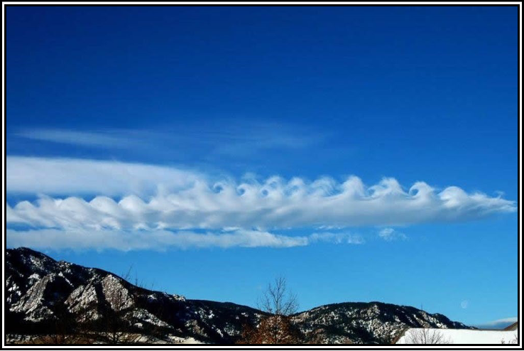
(Photo Credit: University Corporation for Atmospheric Research (UCAR)
Figure . Clouds Associated with Gravity-Shear Waves
K-H waves are quite common in the atmosphere; they can form in the vicinity of thunderstorms, in shear layers near the jet stream, and in association with stable regions of the atmosphere that are topped by a strong wind-shear layer (such as the top of a pool of cold air on the lee side of a mountain). In fact, K-H instability induced by the wind shear associated with strong winds aloft is likely the chief source of high-level turbulence away from mountain ranges (Clear Air Turbulence (CAT)). The mechanism that causes this type of disturbance can be compared to that of a flag flapping in a breeze. The flapping is a result of instabilities created by the wind shear along the flexible surface of the flag, analogous to the wind shear through a very stable (but shallow) layer of the atmosphere.
Vertically Propagating Mountain Waves
Figure 16-5 shows a schematic of a vertically propagating mountain wave. This feature is essentially a standing gravity wave whose energy propagates vertically. For this class of wave, nothing is preventing vertical propagation, such as strong wind shear or neutrally stable atmospheric layers. The mere fact that a wave has developed in air moving over a mountain (or other barrier) does not in itself indicate problems for an aircraft operating in the vicinity. The potential for hazard is a function of the strength of the wave and whether or not an area of the wave “breaks” into turbulent motions that, in the extreme, can lead to structural damage or failure of an aircraft component.
With this type of wave feature, air that is moving nearly perpendicular to the barrier is deflected upward and accelerated as it passes over the crests and down the lee slopes of the terrain. Notice in Figure 16-5 that the standing wave has developed vertically above the mountain crest and that the resulting wave tilts upwind with height. This vertical propagation of the wave means that the effects of the mountain range can be felt at heights significantly above the actual altitude of the peaks (at times reaching in excess of 60,000 ft). As a result, aircraft flying at virtually any altitude may have to deal with significant turbulence and wave-induced altitude excursions. In fact, the amplitude of this type of wave actually increases with height above the mountain (in the absence of atmospheric features, such as strong inversions or shear layers that would tend to partially reflect or absorb the upward-moving wave energy). This amplification is a consequence of the normal decrease in air density with altitude.
The amplitude of the wave will be larger, for the same upstream conditions, the higher the mountain range above the surrounding terrain. Although, even very modest terrain relief can cause appreciable wave activity under the proper conditions. Wave amplitude also will tend to be larger for stronger cross-mountain wind components at mountaintop level. However, the actual amplitude depends on complex relationships between upstream atmospheric wind and temperature profiles and the height and shape of the particular mountain range. Stronger flow across the mountain leads to a deeper wave, given the same atmospheric stability. However, the greater the background stability, the shallower the resulting wave, at fixed-wind speed.
As previously noted, the primary concern for pilots with this type of feature is that the vertical motions of the air moving through the wave may become strong enough to “break” into turbulence. What is meant by “wave breaking”? Looking again at the streamlines that show the airflow in Figure 16-5, it shows that high above the ridge there is a region of updraft. With a wave of modest amplitude (in which the vertical displacement of air moving through the wave is relatively limited), an aircraft flying through this region would likely experience appreciable “wave action,” with altitude and/or airspeed fluctuations, but little turbulence. However, with sufficient amplitude, the wave breaks and localized updrafts and downdrafts occur. The consequences for a pilot flying through this region include airspeed and altitude deviations and the possible sudden onset of severe or extreme turbulence. This type of turbulence occurs typically between 20,000 ft and 39,000 ft MSL and is, therefore, primarily of importance to turboprop and jet aircraft at cruise as they approach and overfly the mountain range.
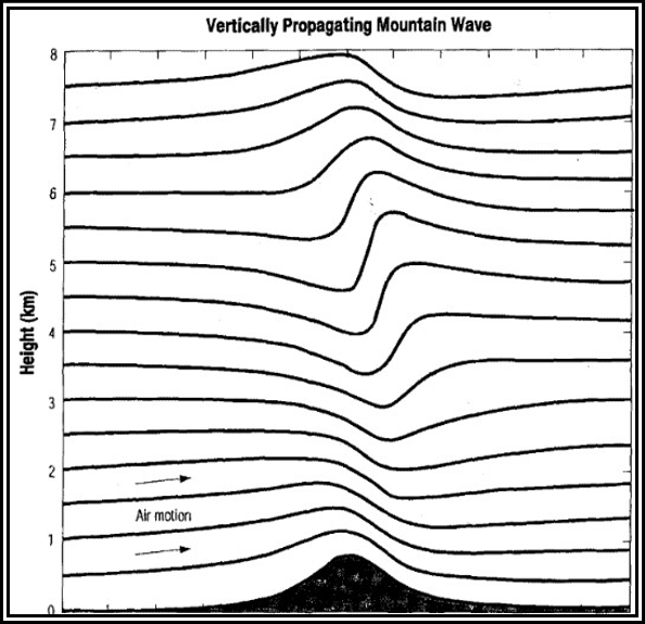
Figure . Schematic of a Vertically Propagating Mountain Wave
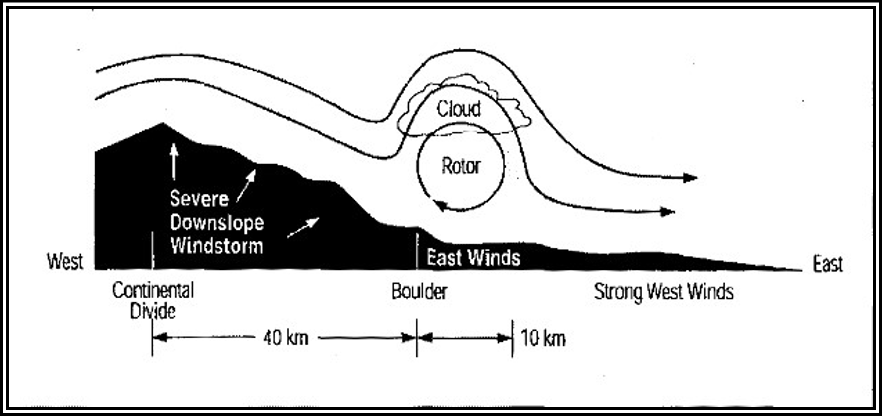
Often accompanying these high-altitude effects is the occurrence of very strong surface winds that result from the wave breaking aloft. In this case, strong downslope winds on the lee slopes can reach 100 kt in gusts, creating a low-level turbulence hazard for all aircraft. Further, these extremely strong low-level winds often abruptly terminate in a “jump” located some distance down the lee slope or well to the lee of the mountains themselves. These features are indicated schematically in Figure 16-6. The jump region is frequently an area of extreme turbulence extending to 10,000 ft or more above the surface. The area of the jump is sometimes marked by a line of ragged rotor clouds exhibiting very turbulent motion. Downwind of the jump, turbulence decreases in intensity but still may be quite strong.

(Source: after Durran and Klemp, 1983)
Figure . Schematic Showing Locations of Jump and Wave Breaking Region of a Vertically Propagating Mountain Wave
Figure shows a schematic of the jump feature, with a pronounced wave and associated strong shear layer. The shear layer (shown in the inset) is a source of the turbulence found with the jump
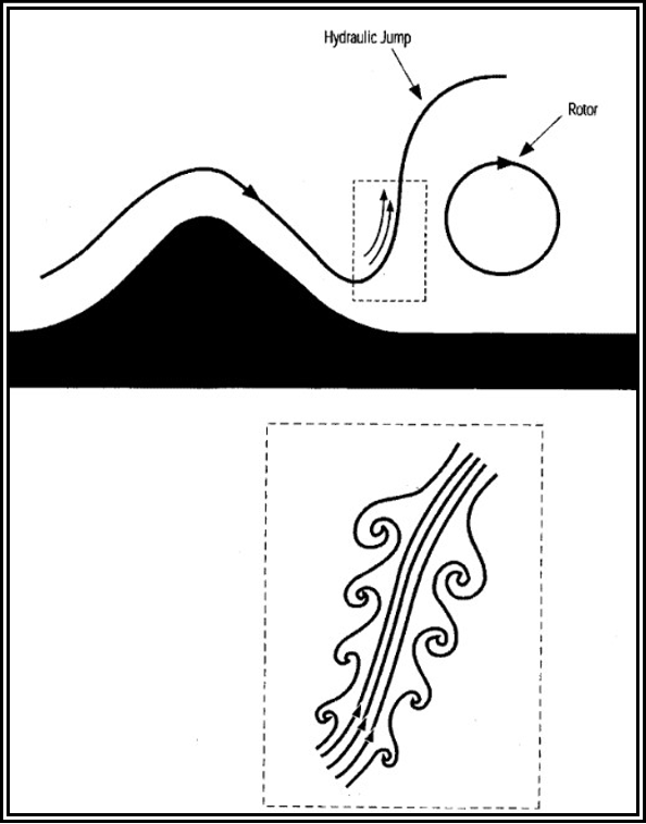
Figure . Schematic of the Strong Shear Zone Associated with a Hydraulic Jump in a Mountain Wave
Trapped Lee Waves
In the preceding section, an important type of mountain wave that propagates (i.e., transports its energy) vertically was discussed. Next, consider a second type of mountain wave, often manifested by a train of Altocumulus Standing Lenticular (ACSL) clouds extending far downwind of the mountain (although trapped lee waves frequently occur without clouds). These waves are of concern for takeoff and landing operations and en route flight below FL250. The associated lenticular (lens- or airfoil-shaped) clouds may appear turbulent or smooth and, depending on the moisture stratification upwind of the mountain, multilayered. They are evident as relatively straight lines or bands of clouds (with clear spaces between), parallel to the mountain range, but downstream from it. The waves that produce these cloud features often are referred to as “trapped lee waves,” because the wave energy is confined below a certain altitude. The mechanism confining this energy is strong wind shear above ridge level. Trapped lee waves are most likely to occur when the wind crosses a narrow mountain range, with a layer close to ridge level and upstream of the mountain that has strongly increasing wind speed with height and high stability, capped by a layer of strong flow and low stability
Figure depicts a trapped lee wave. Notice that this type of wave extends downwind from the mountain, does not develop to a high altitude, and has no upstream tilt, in contrast to the vertically propagating wave in Figure.
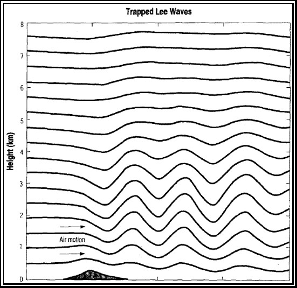
(Source: after Durran and Klemp, 1983)
Figure . Computer Simulation of Trapped Lee Waves Behind a 300-m-High Mountain
This class of wave presents less turbulence hazard at high altitude than do breaking vertically propagating waves, because the wave amplitude decreases with height within the “trapping layer,” typically based within a few thousand feet of the ridge crest. As a result, these waves do not extend to as great an altitude. An exception to this rule is when the atmospheric structure permits only partial trapping. This commonly occurs because the layer of wind shear that is instrumental in the trapping is weaker or shallower than necessary to do the job completely.
However, at lower altitudes, trapped lee waves can create strong turbulence encounters for aircraft. Below lenticular clouds, the wind can be quite variable and gusty, although usually not extremely strong. The gusty winds can extend from the surface up to the base of the clouds, particularly during daylight hours of spring and summer when the sky is otherwise mostly cloud-free. Cloud bases associated with trapped lee waves are typically one to several thousand feet above ridge level, and PIREPs in the vicinity frequently indicate moderate-to-severe turbulence beneath the clouds. The turbulence associated with trapped lee waves is related to the large horizontal and vertical wind shears below cloud level.
With this type of wave, there is frequently a strong shear layer near cloud base immediately to the lee of the mountain range. This separates a turbulent wake region below mountaintop level from the faster-moving, cloud-bearing air above. In the cloud layer itself, conditions typically range from turbulent near cloud base to smooth near cloud top. The clouds themselves give some indication of the degree of turbulence within them; smooth, laminar-looking edges and tops are associated with little or no turbulence, while a lumpy, non-uniform appearance and a visual impression of rolling motion about an axis parallel to the cloud is indicative of turbulence.
Superimposed on the smaller-scale turbulent motions that may be present are larger-scale updraft and downdraft motions that are a part of the wave. Vertical shear of the horizontal wind is locally enhanced at the crests and troughs of the wave as a result of vertical transport (by the wave) of strong winds, leading to shear-induced turbulence. Figure 16-9 shows lenticular clouds associated with a trapped lee wave. Note the laminar appearance of the flow within the cloud that has developed from expansional cooling and condensation of water vapor in the upward-moving portion of the wave. The rolling motions in these clouds associated with a trapped lee wave are repetitive downstream, each cloud band corresponding with a wave crest.
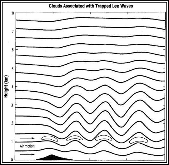
Figure . Lenticular Clouds Associated with a Trapped Lee Wave
Persistent Horizontal Roll Vortices (Rotors)
When mountain waves are present, it is quite common for a rotor zone to develop near or below ridge level on the downwind side of the mountain, under a wave crest and associated lenticular cloud (if sufficient moisture is present). This is an area of potentially severe-to-extreme wind shear and turbulence.
shows a schematic of the wind flow associated with this feature. As illustrated in this figure, rotors typically mark the downwind terminus of a downslope windstorm. When this is the case, the rotor is really part of the “jump” discussed earlier. Although strong rotation is typically present within the rotor zone and associated cloud, a pilot in a moving aircraft may not be able to detect such motion visually until the aircraft is quite close to the vortex. In fact, from a distance, a rotor cloud may look like a rather innocuous cumulus cloud; however, the downwind side of the rotor cloud will typically be rounded in the direction of rotation of the rotor, with cloud tags or streamers at the bottom of the cloud mass. The latter features appear to be rapidly forming and dissipating, thereby giving some sense of rotation within the cloud.
(Source: Bedard, 1993)
Figure . Conceptual View of a Mountain Lee Wave Rotor Zone
Because of their potential for causing turbulence and loss of aircraft control, rotor zones should be avoided. Rotor zones are of concern not only because of the likelihood of strong turbulence in their vicinity (particularly on the upwind side of the rotor), but also because of the potential for rolling moments that could exceed the roll authority of the aircraft or otherwise lead to loss of control. Rotors are especially dangerous at low altitudes, particularly during takeoff and landing, when the aircraft is slowed and in a relatively high-drag configuration.
Smaller-Scale Hazards
The following smaller-scale phenomena represent specific weather hazards for aircraft operating near mountains.
Lee-Side Inversion with Shear Flow (Mountain-Induced Shear with No Wave Development)
Occasionally, an extremely strong low-level temperature inversion can occur in mountainous areas, with the inversion top below ridge level (perhaps 900 to 1,000 ft AGL) and a pool of very cold air at the surface. If this phenomenon occurs with strong wind flow above the inversion layer, there will be a concentrated shear zone near the inversion, which can lead to both significant turbulence encounters and abrupt airspeed changes for aircraft that penetrate the inversion on climbout or during descent. This situation is true particularly when significant mountain wave activity is present above the inversion in the strong flow aloft.
In this case, the surface-based pool of cold air and the inversion above it shelter the surface from what might otherwise be a damaging windstorm.
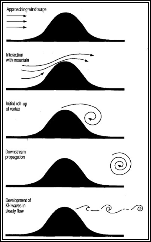
Nonsteady Horizontal Roll Vortices (Moving Horizontal Vortices)
The surge of wind across a ridge can initiate a vortex downwind of the ridge (Figure 16-11). The vortex rolls up to maximum strength of rotation as it continues to move downwind away from the ridge and slowly dissipates. In its wake, with a return to steady flow, K-H waves develop at the top of the shear layer. Extreme gustiness is a characteristic of the surface winds during severe downslope windstorms. The interaction of these gusts with strong large-scale winds moving perpendicular to a ridge may produce strong horizontal vortices of small scale.
(Source: Bedard, 1993)
Figure . Development of a Strong Roll Vortex Associated with a Wind Surge Down the Lee Slope of a Mountain Flight operations may be conducted in the vicinity of strong horizontal vortices without any encounters because they are highly localized, short-lived, and generally cloud-free. Conversely, one or more aircraft may encounter a strong, but invisible, vortex (that might be described as being like a “horizontal tornado,” even though it is not) and undergo rolling moments and localized turbulence that make it impossible for the pilot to maintain aircraft control.
Intense Vertical-Axis Vortices
Analogous to the horizontal vortices described in the previous section are vertically oriented vortices of great intensity, similar to a short-lived, tornado-like event. They can form downwind of localized rugged terrain as well as isolated peaks . These vortices are not associated with thunderstorms and are therefore not tornadoes, but their wind speeds can reach 150 kt or more. As is the case with horizontal vortices, there may be no visual indications (i.e., visible cloud) of the presence of such a strong vertically oriented vortex.
Figure Schematic of Vertically Oriented Vortices Generated in the Lee of an Isolated Mountain Peak.
Boras
The Glossary of Meteorology defines a bora as a “fall wind with a source so cold that, when the air reaches the lowlands or coast, the dynamic warming is insufficient to raise the air temperature to the normal level for the region; hence it appears as a cold wind.” Cold air building up on one side of a mountain range will often be blocked. However, if it deepens sufficiently, it will eventually spill over the mountain barrier and accelerate down the opposite slope, on rare occasions reaching speeds as high as 80 kt. The resulting low-level winds and turbulence can be a significant hazard for aircraft that are flying in the vicinity of the down-rush of air caused by the bora. The danger is heightened by the fact that the exact timing and location of the air surge is difficult to forecast. There are at least two primary causes of boras.
1) cold fronts aligned parallel to the mountain range and moving perpendicular to it, with the cold air eventually spilling over; and 2) cold outflow, from thunderstorms over or near a mountain range, that builds up to sufficient depth to spill over and down the opposite slope. The latter phenomenon is short-lived and very difficult to predict; the strong thunderstorm winds typically last less than 1 hour. However, strong downslope winds accompanying and following cold front passages can persist for several hours. Only the initial stages of such winds have true bora or fall-wind characteristics; these winds appear to evolve into severe downslope windstorms associated with breaking waves aloft and, therefore, become potentially dangerous at all altitudes, not just within a few thousand feet of the surface.
In many areas along the eastern slopes of the Rocky Mountains, and in particular in Colorado, prefrontal windstorms with very warm lee-side temperatures are known as chinooks; post-cold frontal windstorms with cold lee-side winds are often called bora windstorms, or boras. Thus, the term bora in these areas can mean both the initial strong burst of a cold downslope wind and any subsequent downslope windstorm. In the case of eastern-slope boras, the best indicators during the preflight briefing are the presence of a strong cold front moving through the area (i.e., with much colder air behind the front), with associated rapid frontal movement (on the order of 30 kt or more). Surface observations (as reported in a METAR), particularly special observations of strong, rapidly changing surface winds from the west or northwest, along with decreasing temperature, may warn of bora activity. The indicators for breaking internal gravity waves should not be ignored. Western-slope boras are less common and are usually associated with a strong buildup of extremely cold arctic air on the eastern slopes.
Other Phenomena
In addition to the vortex phenomena previously discussed, vortices or strong shear zones may be generated locally by strong flow past individual mountain peaks and crags, or through gaps and passes across mountain ranges.
The point is that strong wind flow in the vicinity of irregular terrain can produce a multitude of disturbances of varying size and strength, many without reliable visual indicators. Their presence should be suspected when flying downwind of rugged terrain, whenever the wind flow at ridge level exceeds about 20 kt.
Visual Indicators of Orographic Wind Fields
Figure 16-13 provides a schematic of mountain waves and possible associated clouds. The most distinctive clouds are the sharp-edged, lens-shaped (or almond-shaped) lenticular clouds. When sufficient moisture is present in the upstream flow, mountain waves can produce interesting cloud formations, including: cap clouds, Cirrocumulus Standing Lenticular (CCSL), ACSL, and rotor clouds . These clouds provide visual proof that mountain waves exist. However, these clouds may be absent if the air is too dry.
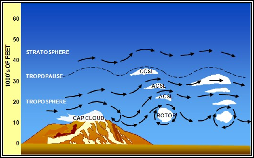
Figure . Schematic of Mountain Waves and Associated Clouds
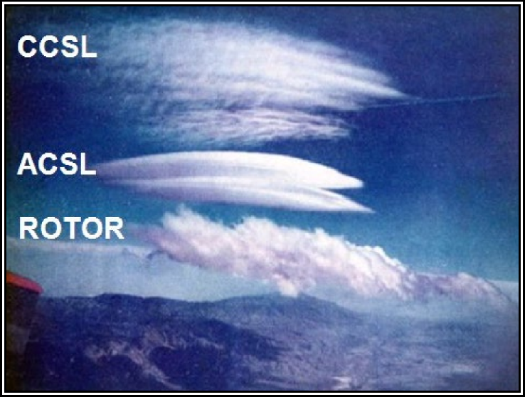
Figure . Examples of Mountain Wave Clouds


