Introduction
Technically, the Tropics lie between latitudes 231⁄2° N and 231⁄2° S. However, weather typical of this region sometimes extends as much as 45° from the Equator. One may think of the Tropics as uniformly rainy, warm, and humid. The facts are, however, that the Tropics contain both the wettest and driest regions of the world.
This chapter describes the basic circulation over the Tropics, terrain influences that determine arid and wet regions, and transitory systems that invade or disturb the basic tropical circulation.
Circulation
Chapter 7, Earth-Atmosphere Heat Imbalances, stated that wind blowing out of the subtropical high-pressure belts toward the Equator form the northeast and southeast trade winds of the two hemispheres. These trade winds converge in the vicinity of the Equator where air rises. This convergence zone is referred to as the Intertropical Convergence Zone (ITCZ). In some areas of the world, seasonal temperature differences between land and water areas generate rather large circulation patterns that overpower the trade wind circulation; these areas are monsoon regions. Tropical weather discussed here includes the subtropical high-pressure belts, the trade wind belts, the ITCZ, and monsoon regions.
Subtropical High-Pressure Belts
If the surfaces under the subtropical high-pressure belts were all water of uniform temperature, the high-pressure belts would be continuous highs around the globe. The belts would be areas of descending or subsiding air, and would be characterized by strong temperature inversions and very little precipitation. However, land surfaces at the latitudes of the high-pressure belts are generally warmer throughout the year than are water surfaces. Thus, the high-pressure belts are broken into semipermanent high-pressure areas over oceans with troughs or lows over continents, as shown in Figure 17-1 and Figure 17-2. The subtropical highs shift southward during the Northern Hemisphere winter and northward during summer. The seasonal shift, the height and strength of the inversion, and terrain features determine the weather in the subtropical high-pressure belts.
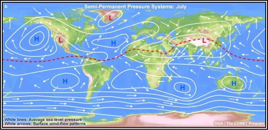
In the warm Northern Hemisphere, warm land areas tend to have low pressure and cool oceanic areas tend to have high pressure. In the cool Southern Hemisphere, the pattern is reversed: cool land areas tend to have high pressure and water surfaces have low pressure. However, the relationship is not so evident in the Southern Hemisphere because of relatively small amounts of land. The subtropical high-pressure belts are clearly evident at about 30° latitude in both hemispheres. The red dashed line shows the ITCZ.
Figure . Mean Worldwide Surface Pressure Distribution and Prevailing Winds Throughout the World in July
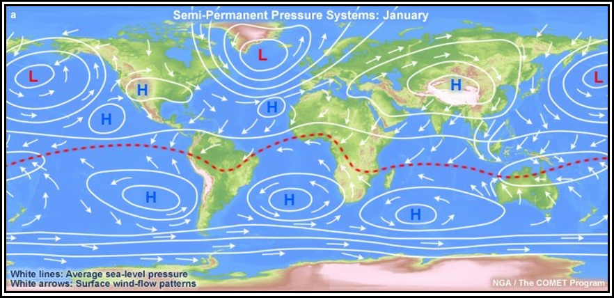
In this season, the pattern from Figure 17-1 is reversed. In the cool Northern Hemisphere, cold continental areas are predominantly areas of high pressure, while warm oceans tend to be low-pressure areas. In the warm Southern Hemisphere, land areas tend to have low pressure and oceans have high pressure. The subtropical high-pressure belts are evident in both hemispheres. Note that the pressure belts shift southward in January and northward in July, with the shift in the zone of maximum heating. The red dashed line shows the ITCZ.
Figure . Mean Worldwide Surface Pressure Distribution and Prevailing Winds Throughout the World in January
Continental Weather
Along the west coasts of continents under a subtropical high, the air is stable. The inversion is strongest and lowest where the east side of the subtropical high-pressure area overlies the west side of a continent. Moisture is trapped under the inversion; fog and low stratus occur frequently. However, precipitation is rare, since the moist layer is shallow and the air is stable. Heavily populated areas also add contaminants to the air which, when trapped under the inversion, add to the visibility problem.
The extreme southwestern United States, for example, is dominated in summer by a subtropical high. Most people are familiar with the semiarid summer climate of southern California. Rainfall is infrequent, but fog is common along the coast.
In winter, the subtropical high-pressure belts shift southward. Consider southern California as an example. In winter, the area comes under the influence of mid-latitude circulation, which increases the frequency of rain. Also, an occasional wintertime outbreak of polar air brings clear skies with excellent visibility.
The situation on eastern continental coasts is just the opposite. The inversion is weakest and highest where the west side of the subtropical high-pressure area overlies the eastern coast of a continent. Convection can penetrate the inversion, and showers and thunderstorms often develop. Precipitation is generally sufficient to support considerable vegetation. For example, in the United States, Atlantic coastal areas at the same latitude as southern California are far from arid in summer. Low ceiling and fog often prevent landing at a west coast destination, but a suitable alternate generally is available a few miles inland. Alternate selection may be more critical for an east coast destination because of widespread instability and associated hazards.
Weather Over Open Sea
Under a subtropical high over the open sea, cloudiness is scant. The few clouds that do develop have tops from 3,000 to 6,000 ft, depending on height of the inversion. Ceiling and visibility are generally sufficient for VFR flight.
Island Weather
An island under a subtropical high receives very little rainfall because of the persistent temperature inversion. Surface heating over some larger islands causes light convective showers. Cloud tops are only slightly higher than those over open water. Temperatures are mild, showing small seasonal and diurnal changes. A good example is the pleasant, balmy climate of Bermuda.
Trade Wind Belts
show prevailing winds throughout the Tropics for July and January. Note that trade winds blowing out of the subtropical highs over ocean areas are predominantly northeasterly in the Northern Hemisphere and southeasterly in the Southern Hemisphere. The inversion from the subtropical highs is carried into the trade winds and is known as the trade wind inversion. As in a subtropical high, the inversion is strongest where the trade winds blow away from the west coast of a continent and weakest where they blow onto an eastern continental shore. Daily variations from these prevailing directions are small, except during tropical storms. As a result, weather at any specific location in a trade wind belt varies little from day to day.
Weather Over Open Sea
In the trade wind belt, on average, about one-half of skies over open water are covered by clouds. Tops range from 3,000 to 8,000 ft, depending on the height of the inversion. Showers, although more common than under a subtropical high, are still light with comparatively little rainfall. Flying weather generally is quite good.
Continental Weather
Where trade winds blow offshore along the west coasts of continents, skies are generally clear and the area is quite arid. The Baja Peninsula of Baja California is a well-known example. Where trade winds blow onshore on the east sides of continents, rainfall is generally abundant in showers and occasional thunderstorms. The east coast of Mexico is a good example. Rainfall may be carried a considerable distance inland where the winds are not blocked by a mountain barrier. Inland areas blocked by a mountain barrier are deserts; examples include the Sahara Desert and the arid regions of the southwestern United States. Afternoon convective currents are common over arid regions due to strong surface heating. Cumulus and cumulonimbus clouds can develop, but cloud bases are high, and rainfall is scant because of the low moisture content.
Flying weather along eastern coasts and mountains is subject to the usual hazards of showers and thunderstorms. Flying over arid regions is good most of the time, but can be turbulent in afternoon convective currents; be especially aware of dust devils. Blowing sand or dust sometimes restricts visibility.
Island Weather
Mountainous islands have the most dramatic effect on trade wind weather. Since trade winds are consistently from approximately the same direction, they always strike the same side of the island; this side is the windward side. The opposite side is the leeward side. Winds blowing up the windward side produce copious and frequent rainfall, although cloud tops rarely exceed 10,000 ft. Thunderstorms are rare. Downslope winds on the leeward slopes dry the air, leaving relatively clear skies and much less rainfall.
Many islands in the trade wind belt have lush vegetation and even rain forests on the windward side, while the leeward is semiarid. For example, the island of Oahu, HI, is about 24 mi wide in the direction of the trade winds. Annual rainfall averages from about 60 in on the windward coast to 200 in at the mountain tops, decreasing to 10 in on the leeward shore.
The greatest flying hazard near these islands is obscured mountain tops. Ceiling and visibility occasionally restrict VFR flight on the windward side in showers. IFR weather is virtually nonexistent on leeward slopes.
Islands without mountains have little effect on cloudiness and rainfall. Afternoon surface heating increases convective cloudiness slightly, but shower activity is light. However, any island in either the subtropical high-pressure belt or trade wind belt enhances cumulus development, even though tops do not reach great heights. Therefore, a cumulus top higher than the average tops of surrounding cumulus usually marks the approximate location of an island. If it becomes necessary for a pilot to ditch in the ocean, the pilot should look for, and head toward, a tall cumulus. It probably marks a land surface, increasing chances of survival.
Intertropical Convergence Zone (ITCZ)
Converging winds in the ITCZ force air upward. The ITCZ appears as a band of clouds consisting of showers (with occasional thunderstorms) that encircles the globe near the Equator. The solid band of clouds may extend for many hundreds of miles and is sometimes broken into smaller line segments. It exists because of the convergence of the trade winds. In the Northern Hemisphere, the trade winds move in a southwesterly direction, while in the Southern Hemisphere, they move northwesterly. The tendency for convective storms in the tropics is to be short in duration, usually on a small scale, but they can produce intense rainfall. It is estimated that 40 percent of all tropical rainfall rates exceed 1 in per hour. Greatest rainfall typically occurs during midday. On the Equator, this occurs twice a year in March and September, and consequently there are two wet and two dry seasons.
Figure 17-1 and Figure 17-2 show the ITCZ and its seasonal shift. The ITCZ is well-marked over tropical oceans, but is weak and ill-defined over large continental areas.
Convection in the ITCZ carries huge quantities of moisture to great heights. Showers and thunderstorms frequent the ITCZ, and tops to 40,000 ft or higher are common, as shown in Figure 17-1. Precipitation is copious. Since convection dominates the ITCZ, there is little difference in weather over islands and open sea under the ITCZ.
Flying through the ITCZ usually presents no great problem if one follows the usual practice of avoiding cumulonimbus clouds and any thunderstorms.
Since the ITCZ is ill-defined over continents, this handbook will not attempt to describe ITCZ continental weather as such. Continental weather ranges from arid to rain forests and is more closely related to the monsoon than to the ITCZ.
Monsoon
over the large land mass of Asia, the subtropical high pressure breaks down completely. Asia is covered by an intense high during the winter and a well-developed low during the summer. The same occurs over Australia and central Africa, although the seasons are reversed in the Southern Hemisphere.
The cold, high pressures in winter cause wind to blow from the deep interior outward and offshore. In summer, wind direction reverses, and warm moist air is carried far inland into the low-pressure area. This large-scale seasonal wind shift is the monsoon. The most notable monsoon is that of southern and southeastern Asia.
Summer or Wet Monsoon Weather
During the summer, the low over central Asia draws warm, moist, and unstable maritime air from the southwest over the continent. Strong surface heating, coupled with rising of air flowing up the higher terrain, produces extensive cloudiness, copious rain, and numerous thunderstorms. Rainfall at some stations in India exceeds 400 in per year with highest amounts between June and October.
The monsoon is so pronounced that it influences circulation many miles out over the ocean. Note in Figure 17-1 that in summer, prevailing winds from the Equator to the South Asian coast are southerly and southeasterly; without the monsoon influence, these areas would be dominated by northeasterly trade winds. Islands within the monsoon influence receive frequent showers.
Winter Monsoon Weather
Note in Figure 17-2 how the winter flow has reversed from that shown in Figure 17-1. Cold, dry air from the high plateau deep in the interior warms adiabatically as it flows down the southern slopes of the Himalayan Mountains. Virtually no rain falls in the interior in the dry winter monsoon. As the dry air moves offshore over warmer water, it rapidly takes in more moisture, becomes warmer in low levels, and is, therefore, unstable. Rain is frequent over offshore islands and even along coastal areas after the air has had a significant overwater trajectory.
The Philippine Islands are in an area of special interest. During the summer, they are definitely in southerly monsoon flow and are subjected to abundant rainfall. In the winter, wind over the Philippines is northeasterly—in the transition zone between the northeasterly trade winds and the monsoon flow. It is academic whether the phenomenon is called the trade winds or monsoon; in either case, it produces abundant rainfall. The Philippines have a year-round humid, tropical climate.
Other Monsoon Areas
Australia in July (Southern Hemisphere winter) is an area of high pressure with predominantly offshore winds, as shown in Figure . Most of the continent is dry during the winter. In January, winds are onshore into the continental low pressure, as shown in Figure. However, most of Australia is rimmed by mountains, and coastal regions are wet where the onshore winds blow up the mountain slopes. The interior is arid where downslope winds are warmed and dried.
Central Africa is known for its humid climate and jungles. Note in Figure 17-1 and Figure 17-2 that prevailing wind is onshore much of the year over these regions. Some regions are wet year-round; others have the seasonal monsoon shift and have a summer wet season and a winter dry season. The climate of Africa is so varied that only a detailed area-by-area study can explain the climate typical of each area.
In the Amazon Valley of South America during the Southern Hemisphere winter (July), southeast trade winds, as shown in Figure , penetrate deep into the valley, bringing abundant rainfall, which contributes to the jungle climate. In January, the ITCZ moves south of the valley, as shown in Figure 17-2. The northeast trade winds are caught up in the monsoon, cross the Equator, and penetrate the Amazon Valley. The jungles of the Amazon result largely from monsoon winds.
Flying Weather in Monsoons
During the winter monsoon, excellent flying weather prevails over dry interior regions. Over water, pilots should pick their way around showers and thunderstorms. In the summer monsoon, low ceilings and heavy rain often restrict VFR flight. IFR flight copes with the hazards of thunderstorms. The freezing level in the Tropics is quite high (14,000 ft or higher), so icing is restricted to high levels.
Transitory Systems
Prevailing circulations are not the only consideration in analyzing weather. Just as important, are migrating tropical weather producers—the shear line, the Tropical Upper Tropospheric Trough (TUTT), tropical waves, areas of converging northeast and southeast trade winds along the ITCZ, and tropical cyclones.
Remnants of Polar Fronts and Shear Lines
Remnants of a polar front can become lines of convection and occasionally generate a tropical cyclone. By the time a cold air mass originating in high latitudes reaches the Tropics, temperature and moisture are the same on both sides of the front. A shear line, or wind shift, is all that remains . These influence storms in the Atlantic Ocean, Gulf of Mexico, or Caribbean Sea early or late in the hurricane season


