Introduction
Aircraft turbulence is irregular motion of an aircraft in flight, especially when characterized by rapid up-and-down motion caused by a rapid variation of atmospheric wind velocities. Turbulence varies from annoying bumpiness to severe jolts, which cause structural damage to an aircraft and/or injury to its passengers. It is important to note that the effect of turbulence varies based on the size of the aircraft. Turbulence intensities and their associated aircraft reactions are described below:
- Light − Causes slight, erratic changes in altitude and/or attitude (pitch, roll, or yaw). Report as Light Turbulence. Or causes slight, rapid, and somewhat rhythmic bumpiness without appreciable changes in altitude or attitude. Report as Light Chop.
- Moderate − Similar to Light but of greater intensity. Changes in altitude and/or attitude occur but the aircraft remains in positive control at all times. It usually causes variations in indicated airspeed. Report as Moderate Turbulence. Or turbulence that is similar to Light Chop but of greater intensity. It causes rapid bumps or jolts without appreciable changes in aircraft altitude or attitude. Report as Moderate Chop.
- Severe − Causes large, abrupt changes in altitude and/or attitude. It usually causes large variations in indicated airspeed. Aircraft may be momentarily out of control.
- Extreme − The aircraft is violently tossed about and is practically impossible to control. It may cause structural damage.
Causes of Turbulence
Turbulence is caused by convective currents (called convective turbulence), obstructions in the wind flow (called mechanical turbulence), and wind shear.
Convective Turbulence
Convective turbulence is turbulent vertical motions that result from convective currents and the subsequent rising and sinking of air. For every rising current, there is a compensating downward current. The downward currents frequently occur over broader areas than do the upward currents; therefore, they have a slower vertical speed than do the rising currents.
Convective currents are most active on warm summer afternoons when winds are light. Heated air at the surface creates a shallow, absolutely unstable layer within which bubbles of warm air rise upward. Convection increases in strength and to greater heights as surface heating increases. Barren surfaces such as sandy or rocky wastelands and plowed fields become hotter than open water or ground covered by vegetation. Thus, air at and near the surface heats unevenly. Because of uneven heating, the strength of convective currents can vary considerably within short distances.
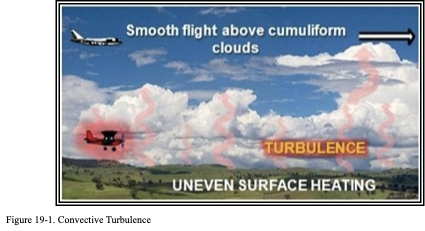
As air moves upward, it cools by expansion. A convective current continues upward until it reaches a level where its temperature cools to the same as that of the surrounding air. If it cools to saturation, a cumuliform cloud forms. Billowy cumuliform clouds, usually seen over land during sunny afternoons, are signposts in the sky indicating convective turbulence. The cloud top usually marks the approximate upper limit of the convective current. A pilot can expect to encounter turbulence beneath or in the clouds, while above the clouds, air generally is smooth (see Figure 19-1). When convection extends to great heights, it develops larger towering cumulus clouds and cumulonimbus with anvil-like tops. The cumulonimbus gives visual warning of violent convective turbulence.
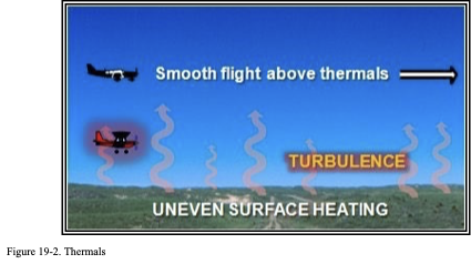
When the air is too dry for cumuliform clouds to form, convective currents can still be active. This is called dry convection, or thermals . A pilot has little or no indication of their presence until encountering the turbulence.
Thunderstorms
Turbulence is present in all thunderstorms, and severe or extreme turbulence is common. A severe thunderstorm can destroy an aircraft. Gust loads can be severe enough to stall an aircraft at maneuvering speed or to cause structural damage at cruising speed. The strongest turbulence within the cloud occurs between updrafts and downdrafts.
Outside the cloud, shear turbulence has been encountered several thousand feet above and up to 20 mi laterally from a severe storm. Additionally, CAT may be encountered 20 or more miles from the anvil cloud edge. These kinds of turbulence are sometimes referred to as Convectively Induced Turbulence (CIT).
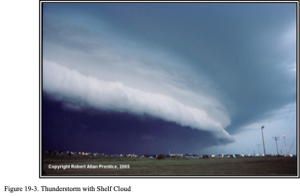
It is almost impossible to hold a constant altitude in a thunderstorm, and maneuvering to do so greatly increases stress on the aircraft. Stresses are least if the aircraft is held in a constant attitude. The low-level, wind-shear zone between the gust front and surrounding air is very turbulent airspace. Oftentimes, the surface position of the gust front is denoted by a line of dust or debris along the ground or a line of spray along bodies of water. Gust fronts often move far ahead (up to 15 mi) of associated precipitation. The gust front causes a rapid and sometimes drastic change in surface wind ahead of an approaching storm. Often, a “roll cloud” or “shelf cloud” on the leading edge of the storm (see Figure 19-3) marks the top of the extreme turbulence zone, which forms as warm, moist air is lifted by the gust front. Shelf clouds are most common with multicell line thunderstorms.
Mechanical Turbulence
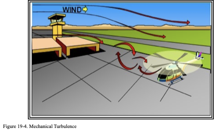
Mechanical turbulence is turbulence caused by obstructions to the wind flow, such as trees, buildings, mountains, and so on. Obstructions to the wind flow disrupt smooth wind flow into a complex snarl of eddies (see Figure 19-4). An aircraft flying through these eddies experiences mechanical turbulence.
The intensity of mechanical turbulence depends on wind speed and roughness of the obstructions. The higher the speed and/or the rougher the surface, the greater the turbulence.
The wind carries the turbulent eddies downstream; how far depends on wind speed and stability of the air. Unstable air allows larger eddies to form than those that form in stable air; but the instability breaks up the eddies quickly, while in stable air they dissipate slowly.
Mountain Waves
Mountain waves are a form of mechanical turbulence that develop above and downwind of mountains. See Chapter 16, Mountain Weather, for information on mountain waves.
Wind Shear Turbulence
Wind shear is defined in Section 19.2.4. Wind shear generates turbulence between two wind currents of different directions and/or speeds . Wind shear may be associated with either a wind shift or a wind speed gradient at any level in the atmosphere.
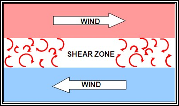
Figure 19-5. Wind Shear Turbulence
Temperature Inversion
A temperature inversion is a layer of the atmosphere in which temperature increases with altitude. Inversions commonly occur within the lowest few thousand feet above ground due to nighttime radiational cooling, along frontal zones, and when cold air is trapped in a valley. Strong wind shears often occur across temperature inversion layers, which can generate turbulence.
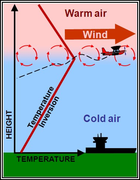
Figure 19-6. Wind Shear Turbulence Associated with a Temperature Inversion
Clear Air Turbulence (CAT)
CAT is defined as sudden severe turbulence occurring in cloudless regions that causes violent buffeting of aircraft. CAT is a higher altitude turbulence (normally above 15,000 ft) particularly between the core of a jet stream and the surrounding air. This includes turbulence in cirrus clouds, within and in the vicinity of standing lenticular clouds and, in some cases, in clear air in the vicinity of thunderstorms. Generally, though, CAT definitions exclude turbulence caused by thunderstorms, low-altitude temperature inversions, thermals, strong surface winds, or local terrain features.
CAT is a recognized problem that affects all aircraft operations. CAT is especially troublesome because it is often encountered unexpectedly and frequently without visual clues to warn pilots of the hazard.
CAT Discussion
One of the principal areas where CAT is found is in the vicinity of the jet streams. There are three jet streams: the polar front jet stream, the subtropical jet stream, and the polar night jet stream. (This handbook does not address the polar night jet stream, as it is a phenomenon in the stratosphere.) See Chapter 9, Global Circulations and Jet Streams, and Figure 9-4 and Figure 9-5 for more information and the polar front jet stream and the subtropical jet stream locations.
CAT associated with a jet stream is most commonly found in the vicinity of the tropopause. CAT is most frequently found on the poleward side of the jet stream (over the United States, this is to the left side when facing downwind). CAT is also common in the vicinity of a jet stream maxima, a region of stronger winds within the jet stream that translates along the jet stream core.
There are several patterns of upper-level winds that are associated with CAT. One of these is a deep, upper trough. CAT is found most frequently at, and just upwind of, the base of the trough, especially just downwind of an area of strong temperature advection. Another area of the trough in which to suspect CAT is along the centerline of a trough area, where there is a strong horizontal wind shear between the jet core and winds to the poleward side of the jet core. CAT is also found in the west side of a trough in the vicinity of a wind maxima as the maxima passes along the trough.
One noteworthy generator of CAT is the confluence of two jet streams. On occasion, the polar front jet stream will dip south and pass under the subtropical jet stream. The wind shear effect between the two jet streams in the region of confluence and immediately downstream is often highly turbulent.
CAT intensity can vary significantly along any flightpath. Common dimensions of a turbulent area associated with a jet stream are on the order of 100 to 300 mi long, elongated in the direction of the wind, 50 to 100 mi wide, and 5,000 ft deep. These areas may persist from 30 minutes to 1 day.
The threshold wind speed in the jet stream for CAT is generally considered to be 110 kt. The probability of encountering CAT increases proportionally with the rapidity of the decrease in wind speed away from the jet core. This is known as wind shear. It is not the wind speed itself that causes CAT; it is the wind shear that is turbulent to an aircraft as the atmosphere bounces in waves or actually overturns. Moderate CAT is considered likely when the vertical wind shear is 5 kt per 1,000 ft or greater, and/or the horizontal wind shear is 40 kt per 150 mi or greater.
Jet streams stronger than 110 kt (at the core) have potential for generating significant turbulence near the sloping tropopause above the core, in the jet stream front below the core, and on the low pressure side of the core.
Wind shear and its accompanying CAT in jet streams are more intense above, and to the lee of, mountain wave ranges. CAT should be anticipated whenever the flightpath traverses a strong jet stream in the vicinity of mountainous terrain.
Both vertical and horizontal wind shear are, of course, greatly intensified in mountain wave conditions. Therefore, when the flightpath traverses a mountain-wave-type of flow, it is desirable to fly at turbulence penetration speed and avoid flight over areas where the terrain drops abruptly, even though there may be no lenticular clouds to identify the condition.
CAT is also related to vertical shear. If vertical shear is greater than 5 kt per 1,000 ft, turbulence is likely.
Curving jet streams are more apt to have turbulent edges than straight ones, especially jet streams that curve around a deep pressure trough.
Wind shift areas associated with pressure troughs and ridges are frequently turbulent. The magnitude of the wind shear is the important factor.
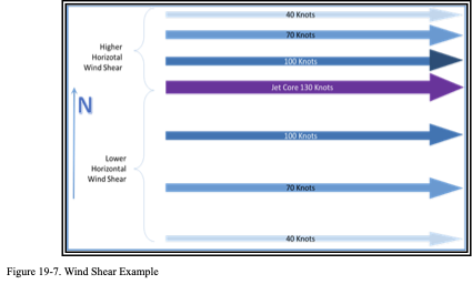
Wind Shear
Wind shear is the sudden, drastic change in wind speed and/or direction over a small area, from one level or point to another, usually in the vertical (see Figure 19-7). Wind shear occurs in all directions, but for convenience, it is measured along vertical and horizontal axes, thus becoming horizontal and vertical wind shear.
It is important to remember that wind shear can affect any flight at any altitude (e.g., at upper levels near jet steams or near the ground due to convection). Wind shear can subject an aircraft to violent updrafts and downdrafts, as well as abrupt changes to the horizontal movement of the aircraft. While wind shear may be reported, it often remains undetected and is a silent aviation weather hazard. Always be alert to the possibility of wind shear, especially when flying in and around thunderstorms and frontal systems.
Some references or publications may use the term “severe wind shear.” They may define the term as a wind shear that exceeds the performance capability of the aircraft or a wind shear producing airspeed changes greater than 15 kt or vertical speed changes greater than 500 feet per minute (fpm).
Nonconvective Low-Level Wind Shear (LLWS)
Wind variations at low altitude have long been recognized as a serious hazard to airplanes during takeoff and approach. These wind variations can result from a large variety of meteorological conditions such as topographical conditions, temperature inversions, sea breezes, frontal systems, and strong surface winds. While wind shear can occur at any altitude, nonconvective LLWS is especially hazardous due to the proximity of an aircraft to the ground. Nonconvective LLWS is defined as a wind shear of 10 kt or more per 100 ft in a layer more than 200 ft thick that occurs within 2,000 ft of the surface. So what does this mean? It means that within the lowest 2,000 ft, the wind speed and/or direction is changing rapidly in a 200-ft layer (see Figure 19-8). Nonconvective LLWS is commonly associated with passing frontal systems, temperature inversions, and strong upper-level winds (greater than 25 kt).
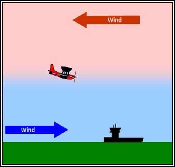
Figure LLWS Example
Convective Wind Shear
See Section for information on convective wind shear.
The Effects of Orographic Winds and Turbulence on Aviation Operations
High-Altitude Operations
Turbine-powered aircraft operating at cruise altitudes above FL180 in the vicinity of mountainous terrain may encounter moderate or greater turbulence associated with orographic winds. This type of turbulence may be characterized by relatively rapid onset and can lead to structural damage or airframe failure.
Structural damage is not the only danger associated with high-altitude turbulence encounters. It is possible to operate some turbine-powered aircraft at such weights and altitudes so that their cruise airspeed is only a few knots below the onset of Mach buffet and a like speed above stall buffet. In this situation (the so-called “coffin corner”), turbulent airspeed excursions of moderate or greater intensity (15 kt or more) can quickly lead to high-speed upset, Mach tuck, and loss of control.
Takeoff and Landing
Takeoff and landing concerns include experiencing turbulent air with inadequate stall margins, loss of directional control on or near the runway, rolling moments that surpass aircraft roll authority, and downdraft velocities that exceed the climb capability of the aircraft, particularly for airplanes with high wing and power-loading. Localized gusts in excess of 50 kt, with downdrafts greater than 1,500 fpm, are also possible.
Vortices spawned by the interaction of strong winds and high terrain can lead to severe turbulence and aircraft rolling moments that may exceed the pilot’s ability to maintain aircraft control.
Low-Level Mountain Flying
Aircraft that engage in low-level flight operations over mountainous terrain in the presence of strong winds (20 kt or greater at ridge level) can expect to encounter moderate or greater turbulence, strong updrafts and downdrafts, and very strong rotor and shear zones. This is particularly true for General Aviation (GA) aircraft. Mountain flying literature often cite 20 kt as the criterion for classifying a wind as “strong.” This criterion refers to the large-scale (or prevailing wind in the area as opposed to a local wind gust) wind speed at the crest of the ridge or level of the mountain peaks, upwind of the aircraft’s position. Such an ambient wind flow perpendicular to a ridge will lead to substantially stronger surface winds, with the likelihood of turbulence. Similar wind enhancements can be anticipated near the slopes of an isolated peak. In contrast, downdrafts over forested areas may be strong enough to force aircraft down into the trees, even when the aircraft is flown at the best rate-of-climb speed. This effect on the aircraft can be exacerbated by loss of aircraft performance because of the high density altitude.


