Introduction
Wind is the air in motion relative to the surface of the Earth. Although people cannot actually see the air moving, it can be measured by its motion of force that it applies on objects. For example, leaves rustling or trees swaying on a windy day indicate that the wind is blowing. Winds are a major factor to both weather and aircraft. Winds cause the formation, dissipation, and redistribution of weather. Winds also affect aircraft during all phases of flight.
Adverse wind is a category of hazardous aviation weather that is responsible for many weather-related accidents. Adverse winds include: crosswinds, gusts, tailwind, variable wind, sudden wind shift, wind shear, and mountain wind hazards. Takeoff and landing are the most critical periods of any flight and are most susceptible to the effects of adverse wind. The most at-risk group is pilots flying aircraft with lower crosswind and tailwind threshold values.
This chapter discusses the origin of wind as well as adverse winds.
Naming of the Wind
Wind is named according to the direction from which it is blowing. For example, a west wind indicates the wind is blowing from the west to the east. There are 36 specific azimuth degrees expressed in intervals of 10 degrees. In aviation, the points of the compass are normally used to represent the direction from which the wind is blowing. For example, north winds come from 360°, east from 90°, south from 180°, and west from 270°.
There are also 16 cardinal compass directions relative to wind. The four primary cardinal directions are north (N), south (S), east (E), and west (W). There are also four intermediate directions, such as northeast (NE), northwest (NW), southeast (SE), and southwest (SW). Additionally, there are eight subdivisions, including north-northeast (NNE), north-northwest (NNW), south-southeast (SSE), south-southwest (SSW), east-northeast (ENE), east-southeast (ESE), west-southwest (WSW), and west-northwest (WNW).
Forces That Affect the Wind
Three primary forces affect the flow of wind: Pressure Gradient Force (PGF), Coriolis force, and friction.
Pressure Gradient Force (PGF)
Wind is driven by pressure differences, which create a force called the PGF. Whenever a pressure difference develops over an area, the PGF makes the wind blow in an attempt to equalize pressure differences. This force is identified by height contour gradients on constant-pressure charts and by isobar gradients on surface charts. PGF is directed from higher height/pressure to lower height/pressure and is perpendicular to contours/isobars. Whenever a pressure difference develops over an area, the PGF begins moving the air directly across the contours/isobars.
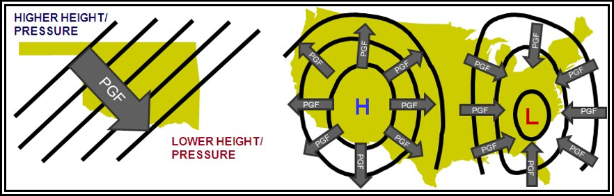
PGF is directed across contours/isobars towards lower height/pressure.
Figure . Direction of Pressure Gradient Force
Wind speed is directly proportional to the PGF, which itself is directly proportional to the contour/isobar gradient. Closely spaced contours/isobars indicate strong winds, while widely spaced contours/isobars mean lighter wind. From a pressure analysis, users can get a general idea of wind speed from contour/isobar spacing.
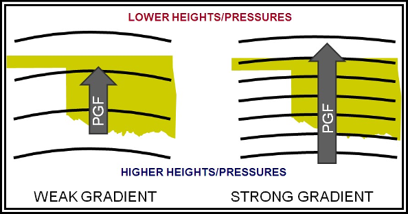
Figure . Magnitude of Pressure Gradient Force
In Figure , on the left panel, the contours/isobars are widely spaced apart, PGF is weak, and the wind speed is weak. On the right panel, the contours/isobars are more closely spaced, the PGF is stronger, and the wind speed is stronger.
The wind would flow from high to low pressure if the PGF was the only force acting on it. However, because of the Earth’s rotation, there is a second force called the Coriolis force that affects the direction of wind flow.
Coriolis Force
A moving mass travels in a straight line until acted on by some outside force. However, if one views the moving mass from a rotating platform, the path of the moving mass relative to his platform appears to be deflected or curved. To illustrate, consider a turntable. If one used a pencil and a ruler to draw a straight line from the center to the outer edge of the turntable, the pencil will have traveled in a straight line. However, stopping the turntable, it is evident that the line spirals outward from the center. To a viewer on the turntable, some apparent force deflected the pencil to the right.
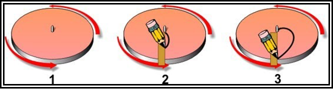
Figure . Illustration of Coriolis Force
A similar apparent force deflects moving particles on the Earth. Because the Earth is spherical, the deflective force is much more complex than the simple turntable example. The principle was first explained by Gaspard-Gustave de Coriolis, and now carries his name—the Coriolis force.
Coriolis force is an apparent force that affects all moving objects. The force deflects air to the right in the Northern Hemisphere and to the left in the Southern Hemisphere.
Coriolis force is at a right angle to wind direction and directly proportional to wind speed; that is, as wind speed increases, Coriolis force increases. At a given latitude, double the wind speed and the Coriolis force is doubled. Why at a given latitude? Coriolis force varies with latitude from zero at the Equator to a maximum at the poles. It influences wind direction everywhere except immediately at the Equator, but the effects are more pronounced in middle and high latitudes.
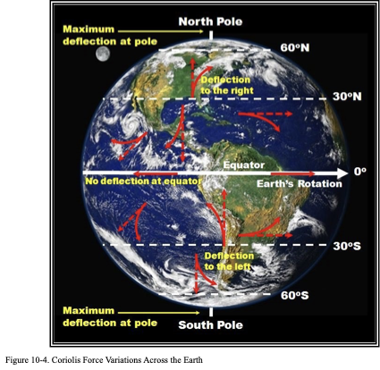
Coriolis force deflects moving objects to the right of their path in the Northern Hemisphere and to the left of their path in the Southern Hemisphere. Coriolis deflection is maximized at the poles and zero at the Equator.
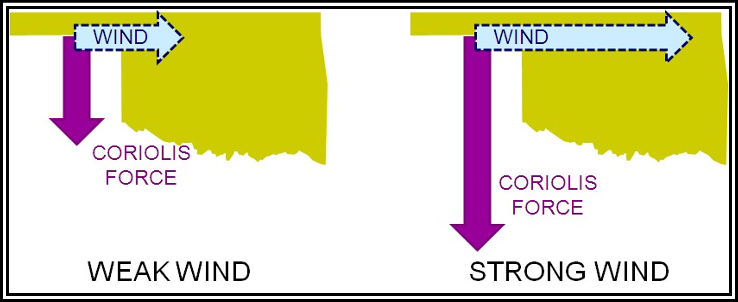
Figure . Coriolis Force Magnitude Variations with Wind Speed
Coriolis force magnitude is directly proportional to wind speed. In Figure 10-5, wind speed is twice as strong in the right panel; thus, the Coriolis force is doubled.
Friction Force
Friction between the wind and the terrain surface slows the wind. The rougher the terrain, the greater the frictional effect. Also, the stronger the wind speed, the greater the friction. One may not think of friction as a force, but it is a very real and effective force always acting opposite to wind direction
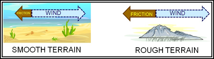
Figure . Friction Force Magnitude Variations with Terrain Roughness
Friction force magnitude is directly proportional to terrain roughness. Even though the wind speed is the same in both panels in, the terrain is rougher in the right panel; thus, the friction force is stronger.
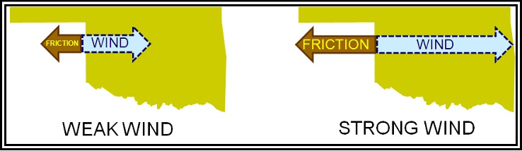
Figure . Friction Force Magnitude Variations with Wind Speed
Friction force magnitude is directly proportional to wind speed., wind speed is twice as strong in the right panel; thus, the friction force is doubled.
The frictional drag of the ground normally decreases with height and becomes insignificant above the lowest few thousand feet. However, this may vary somewhat, since both strong winds and rough terrain extend the friction layer to higher altitudes.
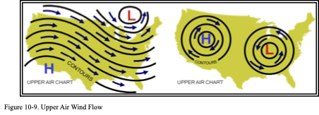
Upper Air Wind
In the atmosphere above the friction layer (lowest few thousand feet), only PGF and Coriolis force affect the horizontal motion of air. Remember that the PGF drives the wind and is oriented perpendicular to height contours. When a PGF is first established, wind begins to blow from higher to lower heights directly across the height contours. However, the instant air begins moving, Coriolis force deflects it to the right. Soon the wind is deflected a full 90° and is parallel to the height contours. At this time, Coriolis force exactly balances PGF, With the forces in balance, wind will remain parallel to height contours as shown in Figure 10-9. This is called the geostrophic wind.
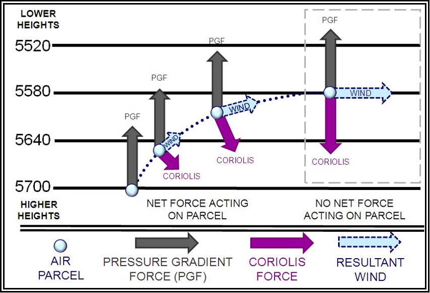
Figure . Geostrophic Wind
Surface Wind
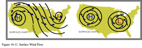
At the surface of the Earth, all three forces come into play. As frictional force slows the wind speed, Coriolis force decreases. However, friction does not affect PGF. PGF and Coriolis force are no longer in balance. The stronger PGF turns the wind at an angle across the isobars toward lower pressure until the three forces balance.
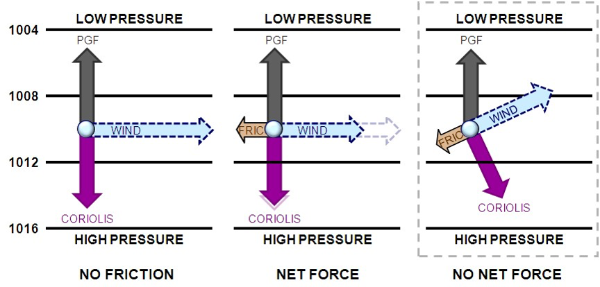
Figure . Surface Wind Forces
The angle of surface wind to isobars is about 10° over water, increasing to as high as 45° over rugged terrain. The end result is, in the Northern Hemisphere, the surface wind spirals clockwise and outward from high pressure, and counterclockwise and inward into low pressure (see Figure 10-11). In mountainous regions, one often has difficulty relating surface wind to pressure gradient because of immense friction and because of local terrain effects on pressure.
Local Winds
Local winds are small-scale wind field systems driven by diurnal heating or cooling of the ground. Air temperature differences develop over adjacent surfaces. Air in contact with the ground heats during the day and cools at night. Low-level pressure gradients develop with higher pressure over the cooler, denser air, and lower pressure over the warmer, less dense air.
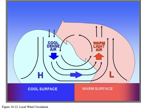
Low-level winds develop in the direction of the PGF. Coriolis force is insignificant, because the circulation’s dimension (less than 100 mi) and lifespan (less than 12 hours) are too short for significant Coriolis deflection. Thus, the wind generally blows from a high-pressure cool surface to a low-pressure warm surface. Air rises over the warmer surface and sinks over the cooler surface. A local wind circulation is easiest to identify when synoptic-scale wind patterns are weak.
Local winds include: sea breeze, land breeze, lake breeze, lake effect, valley breeze, mountain-plains wind circulation, and mountain breeze.
Sea Breeze
A sea breeze is a coastal local wind that blows from sea to land and is caused by temperature differences when the sea surface is colder than the adjacent land. Sea breezes usually blow on relatively calm, sunny, summer days.
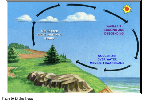
Air above the land becomes warmer (less dense) than air above the water. This is because land heats up faster than water. Low-level pressure gradients develop with lower pressure over the warmer land and higher pressure over the cooler water.
Low-level winds develop in the direction of the PGF. Thus, the wind blows from the water to the land. The air rises over land and sinks over water. Clouds (and precipitation) may develop in the rising air over land with cloud dissipation over the sinking air offshore.
Sea Breeze Front
A sea breeze front is the horizontal discontinuity in temperature and humidity that marks the leading edge of the intrusion of cooler, moister marine air associated with a sea breeze. It often produces a wind shift and enhanced cumulus clouds along its leading edge. Cumuliform clouds may be absent if the air mass being lifted over land is dry or stable
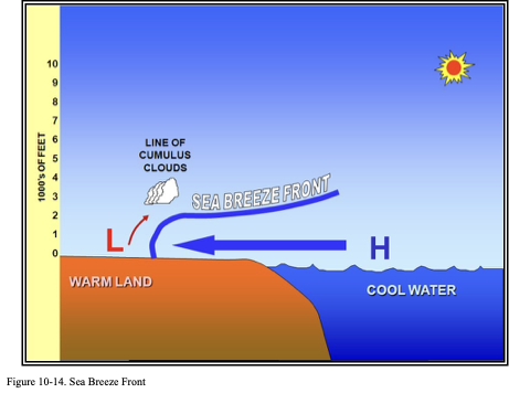
A sea breeze front’s position and movement are influenced by coastline shape, low-level wind direction and speed, and temperature difference between land and sea surface. This temperature difference can be affected by the presence of cloud cover over land and the diurnal cycle. The depth of convection is usually too shallow for precipitation to develop. However, sea breeze fronts can be a lifting mechanism for shower and thunderstorm development.
Effects of Coastline Shape
Locally, the shape of the coastline plays an important role in the development of convection along sea breezes (see Figure 10-15). A narrow peninsula or island is generally an area of strong convective development during the late morning or early afternoon. This is because the sea breezes formed along opposing shores merge near the peninsula’s or island’s center.
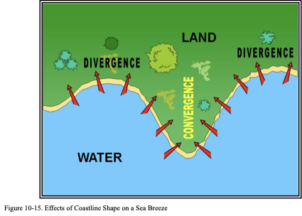
convergence occurs where sea breezes merge from opposite directions. Stronger lift may be sufficient to initiate showers and thunderstorms if the air mass is sufficiently moist and unstable.
Land Breeze
A land breeze (see Figure 10-16) is a coastal breeze blowing from land to sea caused by the temperature difference when the sea surface is warmer than the adjacent land. Land breezes usually occur at night and during early morning.
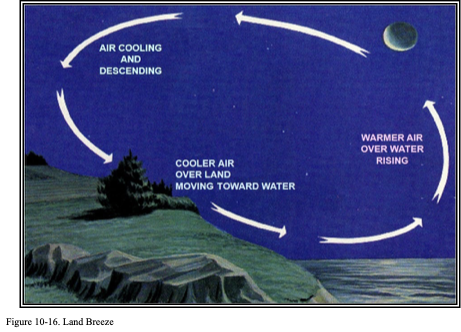
Air above the land becomes cooler (denser) than air above the water due to conduction. This is because land cools faster than water. Low-level pressure gradients develop with higher pressure over the cooler land and lower pressure over the warmer water.
Low-level winds develop in the direction of the PGF. Thus, the wind blows from the land to the water. The land breeze is usually weaker than the sea breeze. The air rises over water and sinks over land. Clouds and precipitation may develop in the rising air over the water.
Lake Breeze
A lake breeze is a local wind that blows from the surface of a large lake onto the shores during the afternoon and is caused by the temperature difference when the lake surface is colder than the adjacent land. The lake breeze is similar in origin to the sea breeze, and is common in the Great Lakes. Both occur during the warm season, primarily spring and summer. Both are easiest to detect in light synoptic wind conditions.
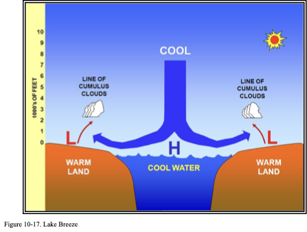
As with sea breezes, thunderstorms are favored in the upward motion branch of the lake breeze circulation. This is especially true where breezes from adjacent lakes collide.
The strength of the lake breeze circulation is affected by a lake’s depth. A shallow lake (e.g., Lake Erie and Lake St. Clair) warms up rapidly and is less effective as the source of a lake breeze in summer than a deep lake (e.g., the other Great Lakes).
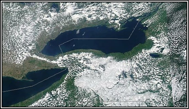
Figure. Sea Breeze/Lake Breeze Example (National Aeronautics and Space Administration (NASA))
the sinking air behind the lake breeze inhibits clouds over Lake Ontario and Lake Erie and for miles inland.
Valley Breeze
A valley breeze is a wind that ascends a mountain valley during the day. Air in contact with the sloping terrain becomes warmer (less dense) than air above the valley. This is because the air in contact with the sloping terrain heats up faster than air above the valley.
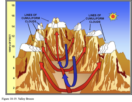
Pressure gradients develop (along a horizontal reference) with lower pressure over the warmer sloping terrain and higher pressure over the cooler valley. Winds develop in the direction of the PGF. Thus, the wind blows from the valley up the mountain slopes. Air rises over sloping terrain and sinks over the valley. Clouds and precipitation may develop over mountain slopes.
Mountain-Plains Wind System
A mountain-plains wind system is the diurnal cycle of local winds between a mountain or mountain range and the adjacent plains. During the daytime, this wind system is the equivalent of one-half of a valley breeze. Air in contact with the sloping terrain becomes warmer (less dense) than air above the plains. This is because the air in contact with the sloping terrain heats up faster than the air above the plains.
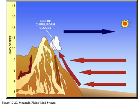
Pressure gradients develop (along a horizontal reference) with lower pressure over the warmer sloping terrain and higher pressure over the cooler plains. Winds develop in the direction of the PGF. Thus, the wind blows from the plains up the mountain slopes. There is a weak return flow aloft. Clouds and precipitation may develop in the rising air over the mountain.
Mountain Breeze
A mountain breeze is the nightly downslope winds commonly encountered in mountain valleys. Air in contact with the sloping terrain cools faster than air above the valley. Pressure over the sloping terrain is higher than over the valleys (along a horizontal reference). Cooler air over the sloping terrain is denser than warmer air over the valley.
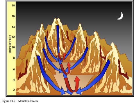
Surface wind flows from the mountain down the sloping terrain into the valley. Air rises over the valley and sinks over the sloping terrain.
Adverse Winds
Crosswind
A crosswind is a wind that has a component directed perpendicularly to the heading of an aircraft (see Figure 10-22). The potential of drift produced by crosswind is critical to air navigation and can have its biggest impact during takeoff and landing. Airplanes take off and land more efficiently when oriented into the wind. The aircraft’s groundspeed is minimized, a shorter runway is required to achieve lift-off, and the pilot has more time to make adjustments necessary for a smooth landing. As the wind turns more perpendicular to the runway to become a crosswind, the airplane’s directional control is affected. If a pilot does not correctly compensate for the crosswind, the aircraft may drift off the side of the runway or side load on landing gear might occur. In extreme cases, the landing gear may collapse.
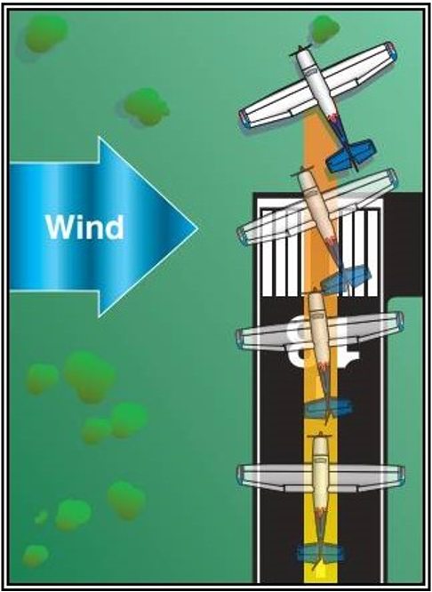
Figure . Crosswind Climb Flightpath
Gust
A gust is a fluctuation of wind speed with variations of 10 knots (kt) or more between peaks and lulls.
Even if the airplane is oriented into the wind, gusts during takeoff and landing cause airspeed fluctuations that can cause problems for pilots. A gust increases airspeed, which increases lift, and may cause an aircraft to briefly balloon up. Once the gust ends, a sudden decrease of airspeed occurs, which decreases lift and causes the aircraft to sink. Gusty winds at the point of touchdown provide significant challenges to a safe landing.
Tailwind
A tailwind is a wind with a component of motion from behind the aircraft.
A tailwind can be hazardous during both takeoff and landing. A longer takeoff roll is necessary because a higher groundspeed is needed to generate sufficient lift, and the aircraft may roll off the end of the runway before lift-off. Also, a smaller initial climb gradient occurs during takeoff, which may be insufficient to clear obstacles at the end of the runway. During a landing, a longer landing roll is needed because the aircraft will touch down at a higher groundspeed. Wind should always be considered in takeoff performance planning.
Variable Wind/Sudden Wind Shift
A variable wind is a wind that changes direction frequently, while a sudden wind shift is a line or narrow zone along which there is an abrupt change of wind direction. Both, even at low wind speeds, can make takeoffs and landings difficult. A headwind can quickly become a crosswind or tailwind.


