This chapter introduces the various classifications of airspace and provides information on the requirements to operate in such airspace. For further information, consult the Pilot’s Handbook of Aeronautical Information, the Aeronautical Information Manual (AIM) and Title 14 of the Code of Federal Regulations (14 CFR) parts 71, 73, and 91.
Powered parachutes (PPC) share the airspace with all other types of aircraft and must avoid the flow of fixed-wing aircraft. Although most PPCs fly low, slow and close to the field, you must be aware of the airspace in which you are operating. Each type of air- space has communication, equipment, visibility and cloud clearance requirements, and therefore may require additional pilot training with logbook endorsements. Some airspace may not be accessible (Class A) while other airspace (Class B and Class C) may not be prudent for PPC operation. Knowing the types of airspace and their requirements is necessary for safe and proper PPC operations.The two categories of airspace are: regulatory and non-regulatory. Within these two categories, there are four types: controlled, uncontrolled, special use, and other airspace.
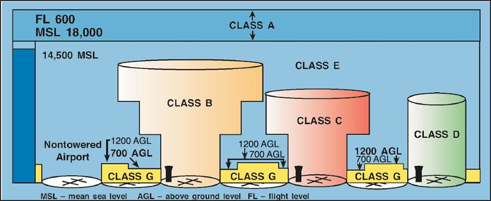
Figure 8-1. Airspace at a glance.
Each type of airspace may have different minimum pilot certification, equipment, visibility and cloud clearance, and entry requirements.
Figure 8-1 presents a profile view of the dimensions of various airspace classes. Figure 8-2 provides the basic weather minimums for operating in the different airspace classes. Figure 8-3 lists the operational and equipment requirements. Refer to these figures as you review this chapter.
Controlled Airspace
Controlled airspace is a generic term that covers the different classifications of airspace and defined dimensions within which air traffic control service is provided in accordance with the airspace classification. Controlled airspace consists of Class A, Class B, Class C, Class D, and Class E.
Class A Airspace
Class A airspace is generally the airspace from 18,000 feet mean sea level (MSL) up to and including 60,000 feet (FL600), including the airspace overlying the waters within 12 nautical miles (NM) of the coast of the 48 contiguous states and Alaska. Unless otherwise authorized, all operation in Class A airspace will be conducted under instrument flight rules (IFR). It is not likely PPCs will be operated in Class A airspace.
Class B Airspace
Class B airspace is generally the airspace from the surface to 10,000 feet MSL surrounding the nation’s busiest airports. The configuration of Class B airspace is individually tailored to the needs of a particular area and consists of a surface area and two or more layers. Some Class B airspace resembles an upside-down wedding cake. At least a private pilot certificate is required to operate in Class B airspace; however, there is an exception to this requirement. Student pilots, recreational pilots, and sport pilots may operate in the airspace if they have received training and a logbook endorsement by an authorized flight instructor in accordance with 14 CFR part 61.
With proper communication equipment, a Mode C transponder (a device that transmits your exact position and altitude), pilot certification and endorsements as required, and an air traffic control (ATC) clearance, a powered parachute may operate in Class B airspace. Due to large jets and congested traffic operating in Class B airspace, powered parachute operations may not be advised.
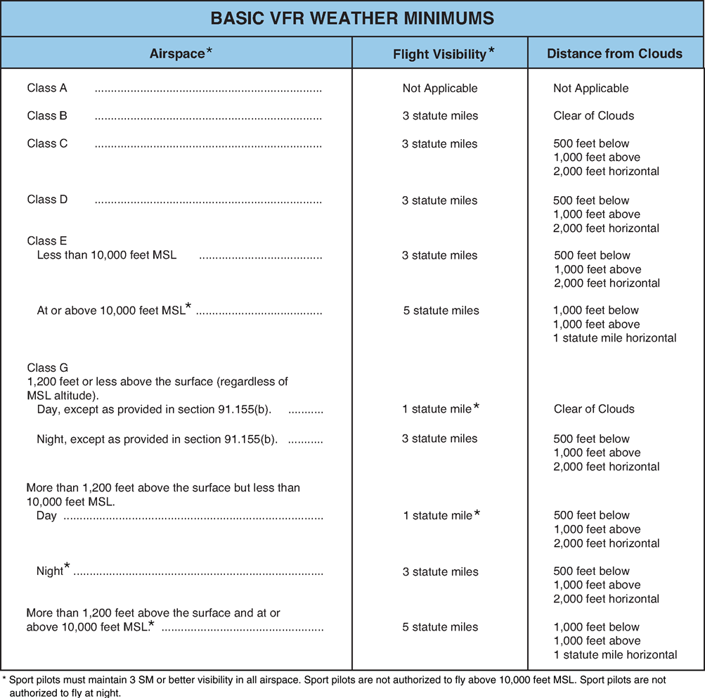
Figure 8-2. Basic weather minimums, from 14 CFR 91.155 and 14 CFR 61.315.
When associated with Class B airspace and within 30 nautical miles of the primary airport, aircraft must be equipped with a Mode C transponder. This requirement must be complied with even if there is no intent to enter the Class B airspace.
Class C Airspace
Class C airspace generally surrounds those airports having an operational control tower, are serviced by a radar approach control, and with a certain number of instrument flight (IFR) operations or passenger enplanements. This airspace is charted in mean sea level feet. Although the configuration of each Class C airspace is individually tailored, the airspace usually consists of a 5 NM radius core surface area that extends from the surface up to 4,000 feet above the airport elevation, and a 10 NM radius shelf area that extends no lower than 1,200 feet up to 4,000 feet above the airport elevation. Though not requiring regulatory action, Class C airspace areas have a procedural Outer Area. Normally this area is 20 NM from the primary Class C airspace airport. Within the outer area, pilots are encouraged to participate but it is not a VFR requirement. With proper communication equipment, a Mode C transponder, endorsements as required, and two-way communications established, a powered parachute may operate in Class C airspace though it may still not be advisable. A Mode C transponder is also required for overflying the Class C airspace.
Class D Airspace
Class D airspace is for smaller airports operating with a control tower and generally extends from the surface to 2,500 feet above the airport elevation surrounding those airports that have an operational control tower. The configuration of Class D airspace will be tailored to meet the operational needs of the area. At many Class D airports, the airspace is configured as a circle with a 4-nautical mile radius around the primary airport. Some are keyhole-shaped. With the proper communication equipment, endorsements as required, and two-way communications established with ATC, a powered parachute may operate within Class D. If advised by ATC to remain clear of the Class D air- space the powered parachute pilot must comply and remain clear of the Class D airspace. Alternatives may include circumnavigating the Class D airspace and/or landing at an alternative airport.
Class E Airspace
Class E airspace is generally controlled airspace that is not designated A, B, C, or D. Except for 18,000 feet MSL, Class E airspace has no defined vertical limit, but rather it extends upward from either the surface or a designated altitude to the overlying or adjacent controlled airspace. With visibility and cloud clearance requirements met, powered parachute operations are not restricted. Most PPC operations take place in Class E airspace.
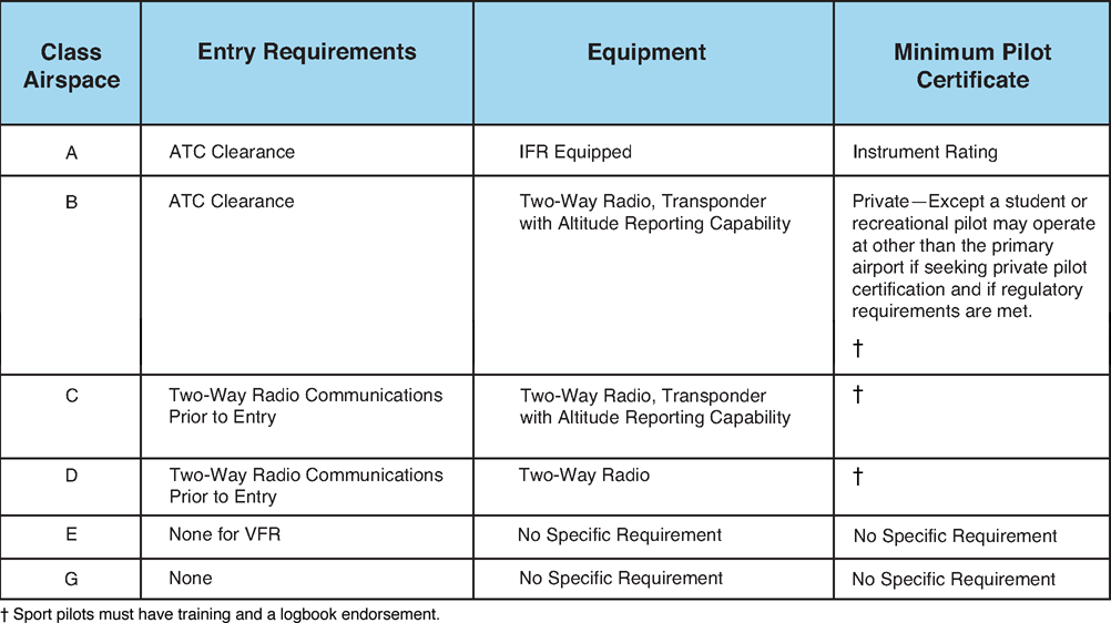
Figure 8-3. Requirements for airspace operations from 14 CFR 61.325.
Uncontrolled Airspace:
Class G Airspace
Uncontrolled or Class G airspace is the portion of the airspace that has not been designated as Class A, B, C, D, or E. It is therefore designated uncontrolled air- space. Class G airspace extends from the surface to the base of the overlying Class E airspace. Although air traffic control has no authority or responsibility to control air traffic in Class G airspace, you should remember there are visual flight rule (VFR) minimums (visibility and cloud clearance) that apply to Class G airspace.
Special Use Airspace
Special use airspace exists where activities must be confined because of their nature. In special use air- space, limitations may be placed on aircraft that are not a part of the activities. Special use airspace usually consists of:
- Prohibited Areas.
- Restricted Areas.
- Warning Areas.
- Military Operation Areas.
- Alert Areas.
- Controlled Firing Areas.
It is important you review the current sectional chart for the area you will be flying in to make sure you avoid operating in special-use airspace without proper training and authority. [Figure 8-4]
Prohibited Areas
Prohibited areas are established for security or other reasons associated with the national welfare. Prohibited areas are published in the Federal Register and are depicted on aeronautical charts.
Restricted Areas
Restricted areas denote the existence of unusual, of- ten invisible hazards to aircraft such as artillery firing, aerial gunnery, or guided missiles. An aircraft may not enter a restricted area unless permission has been obtained from the controlling agency. Restricted areas are depicted on aeronautical charts and are published in the Federal Register. Restricted areas may have altitude limitations and hours of operation. Aircraft operations are not restricted if the restricted area is not active.
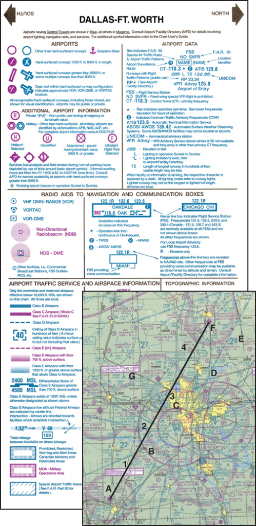
Figure 8-4. Your preflight preparations should include studying the sectional chart to determine in which airspace you will be operating.
Warning Areas
Warning areas consist of airspace which may contain hazards to nonparticipating aircraft in international airspace. The activities may be much the same as those for a restricted area. Warning areas are established beyond the 3-mile limit. Warning areas are depicted on aeronautical charts.
Military Operation Areas
Military operation areas (MOA) consist of airspace of defined vertical and lateral limits established for the purpose of separating certain military training activity from IFR traffic. There is no restriction against a pilot operating VFR in these areas; however, a pilot should be alert since training activities may include acrobatic and abrupt maneuvers. MOAs are depicted on aeronautical charts. MOAs may have altitude limitations and hours of operation.
Alert Areas
Alert areas are depicted on aeronautical charts and advise pilots that a high volume of pilot training or unusual aerial activity is taking place. You should be particularly vigilant while flying in this airspace due to the high volume of training activities.
Controlled Firing Areas
Controlled firing areas contain activities, which, if not conducted in a controlled environment, could be hazardous to nonparticipating aircraft. The difference between controlled firing areas and other special use airspace is that activities must be suspended when a spotter aircraft, radar, or ground lookout position indicates an aircraft might be approaching the area.
Other Airspace Areas
“Other airspace areas” is a general term referring to the majority of the remaining airspace. It includes:
- Airport Advisory Areas.
- Military Training Routes (MTR).
- Temporary Flight Restrictions (TFRs).
- Parachute Jump Areas.
- Published VFR Routes.
- Terminal Radar Service Areas.
- National Security Areas.
- Flights over Charted U.S. Wildlife Refuges, Parks, and Forest Service Areas.
Airport Advisory Areas
An airport advisory area is an area within 10 statute miles (SM) of an airport where a control tower is not operating, but where a flight service station (FSS) is located. At these locations, the FSS provides advisory services to arriving and departing aircraft.
Military Training Routes
Military training routes (MTR) are developed to allow the military to conduct low-altitude, high-speed train- ing. The routes above 1,500 feet AGL are developed to be flown primarily under IFR, and the routes 1,500 feet and less are for VFR flight. The routes are identified on sectional charts by the designation “instrument (IR) or visual (VR).” MTRs with no segment above 1,500 feet AGL are identified by four number characters; e.g., IR1206, VR1207. MTRs that include one or more segments above 1,500 feet AGL are identified by three number characters; e.g., IR206, VR207.
Temporary Flight Restrictions
An FDC Notice to Airmen (NOTAM) will be issued to designate a temporary flight restriction (TFR). The NOTAM will begin with the phrase “FLIGHT RE- RESTRICTIONS” followed by the location of the temporary restriction, effective time period, area defined in statute miles, and altitudes affected. The NOTAM will also contain the FAA coordination facility and telephone number, the reason for the restriction, and any other information deemed appropriate. You should check the NOTAMs as part of flight planning. Flight Service (1-800-WX-BRIEF) can advise you on current TFRs.
Some of the purposes for establishing a temporary
restriction are:
- Protect persons and property in the air or on the
surface from an existing or imminent hazard.
- Provide a safe environment for the operation of disaster relief aircraft.
- Prevent an unsafe congestion of sightseeing aircraft above an incident or event, which may generate a high degree of public interest.
- Protect declared national disasters for
humanitarian reasons in the State of Hawaii.
- Protect the President, Vice President, or other public figures.
- Provide a safe environment for space agency operations.
Parachute Jump Areas
Parachute jump areas are published in the Airport/ Facility Directory. Sites that are used frequently are depicted on sectional charts.
Published VFR Routes
Published VFR routes are for transitioning around, under, or through some complex airspace. Terms such as VFR flyway, VFR corridor, Class B airspace, VFR transition route, and terminal area VFR route have been applied to such routes. These routes are generally found on VFR terminal area planning charts.
Terminal Radar Service Areas
Terminal Radar Service Areas (TRSA) are areas where participating pilots can receive additional radar services. The purpose of the service is to provide separation between all IFR operations and participating VFR aircraft.
The primary airport(s) within the TRSA become(s) Class D airspace. The remaining portion of the TRSA overlies other controlled airspace, which is normally Class E airspace beginning at 700 or 1,200 feet and established to transition to/from the en route terminal environment. TRSAs are depicted on VFR sectional charts and terminal area charts with a solid black line and altitudes for each segment. The Class D portion is charted with a blue segmented line.
Participation in TRSA services is voluntary; however, pilots operating under VFR are encouraged to contact the radar approach control and take advantage of TRSA service.
National Security Areas
National security areas consist of airspace of defined vertical and lateral dimensions established at locations where there is a requirement for increased security and safety of ground facilities. Pilots are requested to voluntarily avoid flying through these depicted areas. When necessary, flight may be temporarily prohibited.
National security areas can be changed to TFRs with very little notice. Check the status of the airspace with the FSS before flying through a national security area.
Flight Over Charted U.S. Wildlife Refuges, Parks, and Forest Service Areas
The landing of aircraft is prohibited on lands or waters administered by the National Park Service, U.S. Fish and Wildlife Service, or U.S. Forest Service without authorization from the respective agency. Exceptions
include:
- When forced to land due to an emergency beyond the control of the operator;
- At officially designated landing sites; or
- An approved official business of the Federal
Government.
Pilots are requested to maintain a minimum altitude of 2,000 feet above the surface of the following: National Parks, Monuments, Seashores, Lakeshores, Recreation Areas and Scenic Riverways administered by the National Park Service, National Wildlife Refuges, Big Game Refuges, Game Ranges and Wildlife Rang- es administered by the U.S. Fish and Wildlife Service, and Wilderness and Primitive areas administered by the U.S. Forest Service.
Powered Parachute Operations
PPC preflight planning should include a review of the airspace that will be flown. A local flight may be close to the field and include only Class G and Class E air- space. Minimum visibility and cloud clearance may be the only requirements for both the pilot and the powered parachute.
If you will be flying through controlled airspace, you must determine if the PPC meets all of the equipment requirements of that airspace. [Figure 8-3] You must also review your qualifications to determine if you meet the minimum pilot requirements of the airspace. If you or the PPC do not meet the minimum aircraft and/or pilot requirements of the airspace, then the preflight planning should include a course around the airspace. Extra time and fuel will be required for the circumnavigation and should be taken into consideration prior to departure. With proper preflight planning, transition or circumnavigation of the controlled airspace should not be a problem for the pilot or the powered parachute.
PPC and Air Traffic Control
In uncontrolled airspace separation from other air- craft is the responsibility of the pilot. Separation from higher speed traffic may require flight paths different than faster traffic. The PPC pilot may be asked to ex- pedite or deviate from a traditional course. The PPC pilot must work with ATC in advising of the airspeed limitations and surface wind speed and direction limi- tations. Safe operation in controlled airspace requires that the controller understand the limits of the pow- ered parachute.
In uncontrolled airspace the responsibility for separation from other aircraft is the responsibility of the pilot. The PPC pilot must be aware that the pilot of the other aircraft may not understand the requirements and/or limitations of the PPC. In operations at uncontrolled airports 14 CFR part 91 requires that PPCs avoid the flow of fixed-wing aircraft.
Regardless of the airspace, see and avoid is a key element of flying in a PPC. The slow speed of the PPC allows it to be overtaken by higher-performance aircraft quickly. Vigilance and proper scanning techniques are extremely important in all airspace, particularly when operating around nontowered airports.
Navigating the Airspace
Knowledge of airspace dimensions, requirements to enter the airspace, and geographical location of the airspace is the responsibility of all pilots. The current sectional chart is the primary official tool to determine the airspace you are flying within or trying to avoid.
Pilotage is navigation by reference to landmarks to determine your location and the location of airspace. Pilotage is the best form of navigation to ensure that you avoid airspace you are not authorized to enter. Locating your position on the sectional chart and locating/identifying the airspace you want to enter/ avoid requires preflight planning on the ground and situational awareness in the air.
GPS is a very popular form of navigation use by powered parachute pilots. The GPS receiver is small, simple to use and inexpensive compared to other forms of electronic (radio) navigation. Simple modes of operation and the aviation database give the pilot a considerable amount of information about the flight, the terrain and Class B, C and D airspace, and special use airspace. Many pilots use GPS to determine distance from airspace with restrictions and/or communications requirements. When using GPS to avoid airspace, allow for a buffer between the aircraft and the airspace. The aviation database in the GPS may not exactly match the airspace as depicted on the sectional chart. If there is a difference between the sectional chart and GPS information, the sectional chart should be considered the correct information.
A PPC pilot using GPS should ensure that the batteries are fresh and the aviation database is current. Never rely entirely on the GPS for navigation. Always back up GPS by using pilotage with a sectional chart and checkpoints when flying beyond the visual range of a familiar airport. In addition, the GPS should be secured in the powered parachute so it does not depart the cart, nor touch the propeller before it stops.


